All Activity
- Past hour
-

Hurricane Erin: 160 MPH - 915mb - W @ 16
DDweatherman replied to BarryStantonGBP's topic in Tropical Headquarters
I’m just razzing you hahaha. I’m excited for tracking though. This is a good appetizer. -
I’d say direct impacts are still unlikely but if EURO is correct it wouldn’t surprise me to see tropical storm advisories hoisted and given the expected size and wind field of the storm wave run up and over wash are almost a guaranteed issue at this point. I was there last week with the full moon and nor Easter and there wasn’t any beach at all
-
0.0” from that. he is here he is there he is everywhere.
-

Hurricane Erin: 160 MPH - 915mb - W @ 16
marsman replied to BarryStantonGBP's topic in Tropical Headquarters
50+ mph gusts in northern BVI. -
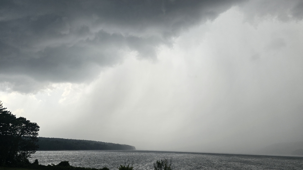
Absolutely frog strangling storm out there currently. It was so humid, I figured something had to give at some point.
-
Nice shots. There’s nothing like weather advancing over water.
-
"Meanwhile, dewpoints start off the week in the 40s and 50s meaning no high humidity to speak of, though dewpoints may creep up into the 60s briefly on Wednesday before drier air is once again pulled in behind the exiting tropical system"
-
I told you its coming For weenies in Hatteras
-
Hurricane Erin: 160 MPH - 915mb - W @ 16
marsman replied to BarryStantonGBP's topic in Tropical Headquarters
Possible NC12 overwash. NCDOT may canx some of the ferries too. The bold is my add: -
I don’t mean cane or direct effects. But it will not be a Coc k / smoke week as has been advertised. Not straight thru anyway
-
Tell me about it. Half my family is on Ocracoke this week for vacation. Ferries are filling up quick.
-

Hurricane Erin: 160 MPH - 915mb - W @ 16
Amped replied to BarryStantonGBP's topic in Tropical Headquarters
The inverted troff to the north is going to be funneling winds into the Mid Atlantic coast. This could help push some waves onshore. -
Oh yee of little faith.
-

Hurricane Erin: 160 MPH - 915mb - W @ 16
BarryStantonGBP replied to BarryStantonGBP's topic in Tropical Headquarters
u wot m8 I just landed in ibiza while checking on erin updates outside pacha and the first thing I see is me being mistaken for a chihuahua anyway did an ERC get to her yet? she seems steady -
Hurricane Erin: 160 MPH - 915mb - W @ 16
BarryStantonGBP replied to BarryStantonGBP's topic in Tropical Headquarters
what's "resent" -
its not done trending either..
-
It affects our sensible wx next week too, Bigger implications
-
Quick hit heavy rain and a nice breeze

-
 There are still idiots on X saying there's still a threat to the EC for a landfall
 -
Picked up a quick tenth of an inch to bring the monthly total to .83”. temp down to 78f with 76dp. Soupy
-

Hurricane Erin: 160 MPH - 915mb - W @ 16
NorthHillsWx replied to BarryStantonGBP's topic in Tropical Headquarters
EURO GFS and ICON are all uncomfortably close to OBX now -
 Hurricane will be expanding in size as well which expands the fetch.
 -
Today reminds me of the Plainfield tornado day back in 1990. Powerful southeastward moving storms over northeast IL while we baked under full sun out in the western portion of the state.
-
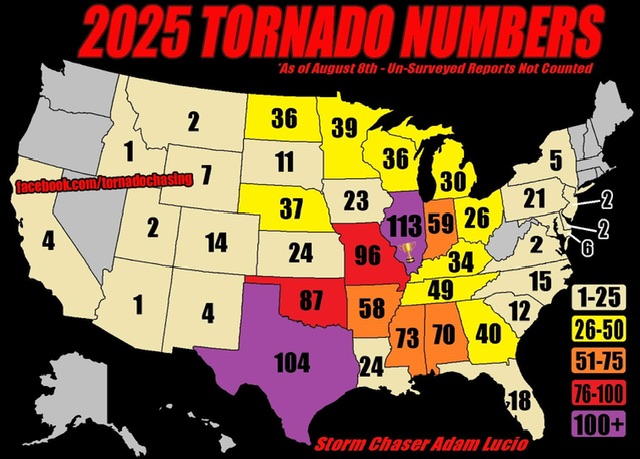
Map is supposedly from 8/8, but nothing since then that I am aware of.
-
Gfs with a solid 100 mile tic west. Again just news for Hatteras and Bahamas with possible Tropical Storm Conditions.


