All Activity
- Past hour
-

December 2025 regional war/obs/disco thread
WxWatcher007 replied to Torch Tiger's topic in New England
Yes, I think that signal is real for the 26-27th. We’ve been talking about it for a week now and it’s looking like at least a substantial part of New England is going to stay on the cold enough edge of this overall pattern that’ll flood areas to our south and west with warmth. Doesn’t mean it’ll be all frozen the rest of December, just that unlike virtually the rest of the CONUS we will have our chances to produce. -
I seem to recall that it did, my 2-month total from Dec 2023 to Jan 2024 was 13” of precip. With canada torched, it was just too warm for snow. Ironically the only snows we got were when the STJ took a break.
-

Winter 2025-26 Medium/Long Range Discussion
Baum replied to michsnowfreak's topic in Lakes/Ohio Valley
Hearing rumors my 60 degree Christmas is getting flushed. -
Don't know if anyone saw this, but worth a quick read regarding new NOAA modeling. https://www.noaa.gov/news-release/noaa-deploys-new-generation-of-ai-driven-global-weather-models
-

White Christmas Miracle? December 23-24th
SouthCoastMA replied to Baroclinic Zone's topic in New England
6z euro still had the invt trough glazing the cape. Downeast Maine gets slaughtered with it -
December 2025 regional war/obs/disco thread
SouthCoastMA replied to Torch Tiger's topic in New England
6z Euro looked real good for 12/26-27 -

White Christmas Miracle? December 23-24th
TalcottWx replied to Baroclinic Zone's topic in New England
He gone -
Even our brief Nino a couple years ago didn’t seem to really get the STJ going for any amount of time. Hopefully next year’s will
-

December 2025 Short/Medium Range Forecast Thread
Carvers Gap replied to John1122's topic in Tennessee Valley
The 0z Euro, 0z CMC, and 6z GFS all move a trough into the East which looks to possibly have some staying power. The CMC is much quicker and the GFS is the slowest. But they all get tend get to a similar point. Starting to be concerned the Music City Bowl is going to be cold. -

December 2025 regional war/obs/disco thread
Damage In Tolland replied to Torch Tiger's topic in New England
Maybe ice/ snow 26-28 -
End of both eps and gefs begin to fade the SER, hint of height rises in the west. Large scale features largely the same, though.
-

White Christmas Miracle? December 23-24th
WinterWolf replied to Baroclinic Zone's topic in New England
That’s what these models seem to do now…every system this seems to happen. Back and forth…up to the day before. As you said, 1-3” and call it a forecast. -
December 2025 regional war/obs/disco thread
WxWatcher007 replied to Torch Tiger's topic in New England
Still a huge discrepancy in sensible wx between Euro and GFS for Boxing Day, but the cold press has been gradually trending on the GFS. Euro would be impactful verbatim. -
Torrential snow continues and has been pouring down at Palisades all night. It is pretty. But it is all for Naught. It is all melting on contact. Might as well be heavy rainfall. Western ski resorts are done after this winter, probably even before the winter is finished. La Nina is pushing record amounts of Pacific Puke across the mountain ranges along with very warm airflow, resulting in temps just mild enough for 'Mid Atlantic Classic Snow Futility' that ensures DC-like results, every time with every storm there this entire winter. Results: Slush on ground. Terrible to ski on. Tremendous lost revenue. Ski resorts must shut down; if anything it's because of insurance concerns. Just enough snow to tease everyone, but not enough to ski on safely, due to spicyness/dangerous obstacles like boulders, logs, smaller rocks, etc etc. Brown/Gray outright yucky depressional epically GRINCH Christmas and a horribly UNHAPPY UNPROFITABLE New Year for the western ski resorts as disgruntled customers begin shouting for refunds, even rioting. The UGLY specter of record million-year landslides/rockslides sweeping many right off roads on their way home from record rains on the mountains/hypersaturated soils/loosened rocks, trees, debris, etc etc.
-

Mid to long range discussion- 2025
Leesville Wx Hawk replied to wncsnow's topic in Southeastern States
I see it GaWx. A whole lot would have to come together in that scenario but at least it’s something to watch. . -
If it snows to our south again before we get snow (based on last nights model run), I give up
-

December 2025 regional war/obs/disco thread
moneypitmike replied to Torch Tiger's topic in New England
Today back in 2016 held a different vibe n GC.
-
Wdym? All I was saying that I’m waiting until the weeklies are more consistent for at least a few days instead of flip flopping. Only then I’ll think there’s some credibility to their forecasts.
-

White Christmas Miracle? December 23-24th
Sey-Mour Snow replied to Baroclinic Zone's topic in New England
Yup RRFS has now joined the NAM rankings .. although seems like every model is flip flopping around with this one .. I think you just paint a 1-3” across all the northeast and see what happens lol -
Is this year 3 of drought? Before this dry period it was wet for a few years but that didn't help snow totals lol
-

White Christmas Miracle? December 23-24th
Great Snow 1717 replied to Baroclinic Zone's topic in New England
Can you please REMOVE me from THAT Xmas card list?? LOL..thanks in advance!! -
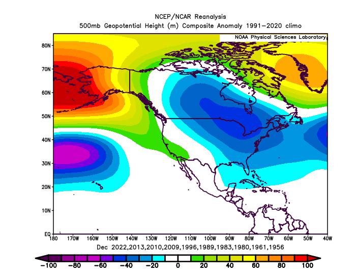
This has to be the most extreme -WPO +EPO dipole that we have seen in December. Lead to the unusually strong ridge out West with the -PNA for such a strong -WPO. Record Pacific Jet and historic flooding in the Pacific Northwest. Strong December -WPO 500 mb composite more -EPO snd weaker Western U.S. ridge
-
Years
-
We can’t seem do get out of this liquid drought. Stj has been dead for months
-
Yeah that continues to be the period to keep an eye on. Various op runs have had a snow/mix event for the MA/NE the last few days. Weakish signal on the Ens runs.


