All Activity
- Past hour
-
Euro cut way back
-
West and north is worst this weekend into next week. East is stein until Tuesday or so although a few showers can’t be ruled out. Could be showers and a few tstms tonight after midnight.
-
yeah it seems like Mon-Wed is the real wet period but who knows with a cutoff low where it actually ends up.
-
Area of early AM clouds moving East, clouds to the West currently in Ohio and West VA., nicest day for a while today. Dew 37 F.
-
That's a good amount of rain if it verifies. I just wish it wasn't going to take 5-6 consecutive dark and dreary days to get it.
-
Dan Zarrow thinks there is still a shot we avoid the heavy rains as the system shifts further offshore. Hope he is right. No one wants gloom and days and days of rain
-
This Spring has felt like the first "normal" Spring in a long time. Yes it's been a little wetter in some areas but at least its not gone from cold to broiler in a week. It seems like the past few years we almost skipped Spring and went straight into summer. This Spring reminds me of the Springs of my youth in Indiana so far. Now the "Springs" of my youth in Apple Valley CA, thats a different story lol.
-
0.31" here overnight, maybe a bit better than expected. I was able to fill my rain barrel before we head into the long dry stretch.
-
Do you have a Tesla battery Tip?
-
Weekend looks fine for most of SNE
-
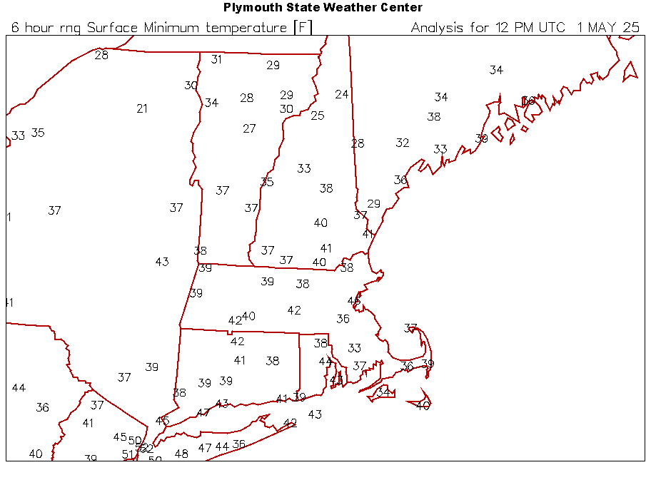
Wow. 27.8° for the low here.
-
Mins LWM colder than CON
-
33 in TAN. 44 here.
- Today
-
Weather apps?
-
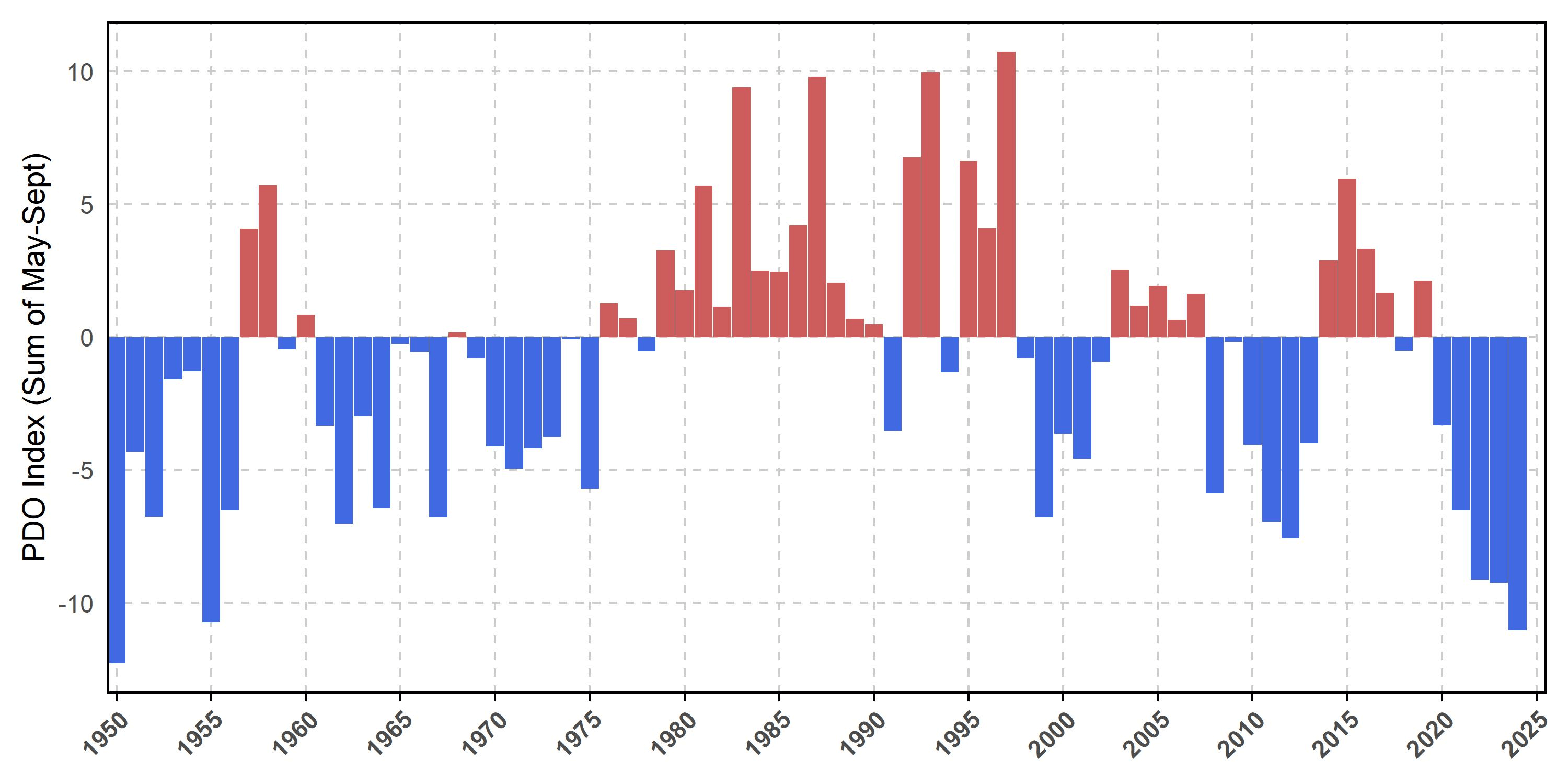
Thanks Chris, Keep in mind that that analysis is likely based on the Mantua et al PDO, which is more positive than NOAA’s, and is definitely based on only May-Sept for whatever reason (see image below). But if they had done it based on NOAA, it would have been more negative. In addition, why not look at the entire year?
-
It just never really went calm here until near sunrise too…a pesky 5mph most of the night.
-
Underperformer here with only 0.38" overnight. Looks pretty dry the first half of May.
-
Monthly Dep: Site : Dep (AVG) / Rainfall (Normal) EWR: +2.7 (56.1) / 2.39 (N3.9) JFK: +2.9 (53.8) / 2.17 (N3.60) LGA" +1.7 (55.4) / 2.84 (N3.90) NYC: +1.6 (55.3) / 3.25 (N4.20)
-
33.3⁰ this morning, enough of this garbage now....the house got down to 62⁰ too
-
Hopefully not the dreaded north trend and congrats to places that don't need rain lol
-
Well partly sunny and mainly south of pike.
-
Records: Highs: EWR: 88 (2010) NYC: 87 (2001) LGA: 85 (2001) JFK: 81 (2001) Lows: EWR: 36 (1978) NYC: 35 (1880) LGA: 38 (1978) JFK: 38 (2008) Historical: 1854 - The Connecticut River reached a level of nearly twenty-nine feet at Hartford (the highest level of record up until that time). The record height was reached in the midst of a great New England flood which followed sixty-six hours of steady rain. (David Ludlum) 1857: The Washington Evening Star publishes the first US national weather summary using observations from volunteers to the Smithsonian Institution's cooperative network. 1933: An estimated F4 tornado struck Minden, Louisiana, killing 28 people and injuring 400 others. 500 homes were damaged or destroyed with $1.3 million in damage. 1935 - Snow, ice and sleet brought winter back to parts of southeast Minnesota. Minneapolis received three inches of snow to tie their May record which was established in 1892. (1st-2nd) (The Weather Channel) 1954 - The temperature at Polebridge MT dipped to 5 degrees below zero to esablish a state record for the month of May. (The Weather Channel) 1987 - Thunderstorms produced large hail and heavy rain in Texas. Baseball size hail pounded Dublin, and 3.75 inches of rain soaked Brady. (The National Weather Summary) (Storm Data) 1988 - Strong southerly winds ahead of a cold front crossing the Rocky Mountain Region gusted to 90 mph at Lamar CO. High winds created blinding dust storms in eastern Colorado, closing roads around Limon. (The National Weather Summary) (Storm Data) 1989 - Thunderstorms produced heavy rain in the southeastern U.S. Rainfall totals of 1.84 inches at Charlotte NC and 2.86 inches at Atlanta GA were records for the date. Strong thunderstorm winds uprooted trees in Twiggs County GA. (The National Weather Summary) (Storm Data) 1990 - Thunderstorms produced severe weather from northern Alabama to North Carolina. There were sixty-three reports of large hail or damaging winds, with hail four inches in diameter reported near Cartersville GA. Ten cities in the southeastern U.S. reported record high temperatures for the date as readings warmed into the 90s. Jacksonville FL reported a record high of 96 degrees. Late night thunderstorms over central Texas produced up to ten inches of rain in southern Kimble County and northern Edwards County. (The National Weather Summary) (Storm Data) 1999: Record, low temperatures for the date, were broken in the Deep South. Mobile, Alabama dropped to 46 degrees. Miami fell to 58; Miami Beach bottomed out at 61, and Vero Beach dropped to 47 degrees, all new records. Other stations in Florida also set record cold maximums for the date, including 61 at Jacksonville and Daytona Beach with 66 degrees.
-
It looks like 3-4 inches of rain for some of Pa. till next Wednesday. But i'm sure that will change with time.
-
54 / 37 off a chilly low of 43. Upper 60s to near 70 today in what will likely be the nicest day (sun - wise) till next Thu or Friday. A very warm Fri but it looks quite cloudy, any longer breakd gets the war m spots to mid 80s. Cut off low to our west this weekend keeps clouds and a warmer humid/southerly flow. Rain Sat/Sun from more scattered areas of showers, rain and some tstorms. Cutoff heads east Mon - Wed and latest forecasts bring 2- 4 inches of rain or more in the higher spots total from 5/3 - 5/8. Beyond there more near normal overall between 5/9 - 5/14. No strong warmth / ridging looking till mid month and post mid month.
-
Saturday maybe. Don't see it being sunny on Sunday.