All Activity
- Past hour
-

Central PA Winter 25/26 Discussion and Obs
Jns2183 replied to MAG5035's topic in Upstate New York/Pennsylvania
14 miles in 12 minutes Sent from my SM-S731U using Tapatalk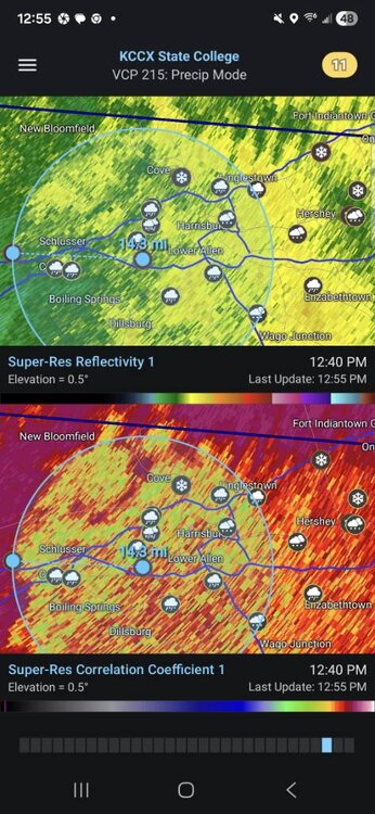
-
6” even on my deck. Dumping.
-
 it was the same here.. now pounding and perfect snow growth
 -
Truly fascinating to see these dynamics. Almost in the mid-50s north of us. Sitting at 24 here.
-
 6 hr measure is 4.7", growth has been wavering between sand and excellent when bands move through, but vis is well under 1/4sm for hours now... and we just gettin started.
 -
i must be on the northern side of you...just starting to ping
-
Visibility in Arlington back under a half-mile. Some very tiny precipitation is falling. Maybe an inch of sleet stuck to cleared sidewalks??
-

January 2026 Medium/Long Range Discussion
Scarlet Pimpernel replied to snowfan's topic in Mid Atlantic
That's kind of what I'm thinking too. Maybe that clipper-type system around Friday but it's the time after that perhaps that may be good, hopefully! In fact, yeah it's an ops deterministic, but today's 12Z GFS shows an "incoming" potential at the end of its run at 360-384 hours!! CMC kind of hints at something too around hour 240 (end of its run). ECMWF, nothing much in particular but hints of stuff "out there" in time. Key takeaway for me is, we should have some tracking going on for awhile, and hopefully we'll cash in and score! -

January 25-26 Winter Storm Potential
Lucy Pull replied to Ralph Wiggum's topic in Philadelphia Region
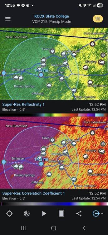
Starting to hear some louder “flakes” hit the windows here just south of Blue Mountain Ski Resort. Some larger flakes mixing in with the pixie dust as well. Think we may end up in a battle zone here. Correlation Coefficient showing the mix line starting to crash south in central PA again. -
Major Burriage here in Bloomfield!
-
We’ve gotten a lot here. No idea how much, but there ain’t no way to hide your lyin’ eyes. .
-
 Pounding. These are the days we spend so much time tracking and hoping for
 -
pingers mixing in 1pm just like the nam said
-

2025-2026 Fall/Winter Mountain Thread
Rainforrest replied to Buckethead's topic in Southeastern States
Temp continues to drop. Down to 28. -

E PA/NJ/DE Winter 2025-26 Obs/Discussion
Ralph Wiggum replied to LVblizzard's topic in Philadelphia Region
Let's do a repeat in 2 weeks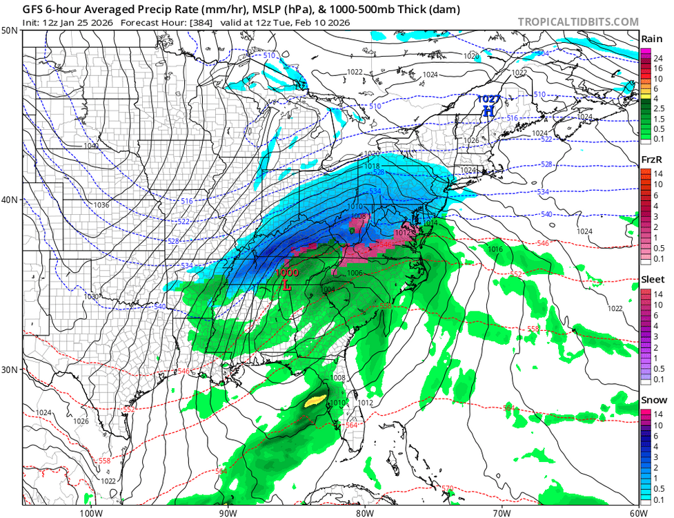
-

Pittsburgh/Western PA WINTER ‘25/‘26
EVLINC64 replied to Burghblizz's topic in Upstate New York/Pennsylvania
Still snowing pretty good in West Newton -
still snowing hard here.
-
Some of the heaviest snow in several years here in the UWS, can barely see the building across the street!
-

1/24-1/25 Major Winter Storm - S. IL, IN, and OH
RCNYILWX replied to A-L-E-K's topic in Lakes/Ohio Valley
If that has staying power, might need to upgrade some more counties to a WSW. I'm not at work so I can't speak to it but I do wonder if it's being considered. Would think your area, south burbs to especially northwest Indiana is prime bc they're going to be under lake enhancement and then pure lake effect for a while longer. Can see the LE under the synoptic snow into Lake County Indiana from tMDW. Sent from my SM-S936U using Tapatalk -

Southern Crippler - Get well soon Jimbo Storm Obs
WinstonSalemArlington replied to BooneWX's topic in Southeastern States
Winston-Salem -
7 inches in Astoria. One inch in the past hour. Still all snow.
-
Sleet nudged back south a touch on the radar with the heavy band.
-
7” in Morristown- Heavy Snow - sleet line creeping closer.
-
 Sucking a little exhaust right now but at least still coming down good...just some reduced flake size from earlier
 -
Correct on montgomery .


