All Activity
- Past hour
-
Agreed. Let's lock in with light to mod.ecent one after the other. Don't blow a good pattern on one big storm that melts off in a few days, especially leading into Christmas.
-
 Translation to what you’re really thinking: Look at all this snow I’m going to get over the next few days . It’s hard to believe but it’s coming and I am excited . It’s satisfying knowing I live in a place that gets this much snow and I have to let you all know
 - Yesterday
-
Robust 850mb vortmax about to collide with the spine. Solid upward tick in BTV accumulation forecasts for tomorrow. 5-9” on the point and clicks for favored summits during the daytime period
-
New England 2025 Warm Season Banter
Damage In Tolland replied to bristolri_wx's topic in New England
Holy shit man. Get the FOC out of there. Early September look -
Yep now we need a boost in the Kp
-

2025-2026 ENSO
Stormchaserchuck1 replied to 40/70 Benchmark's topic in Weather Forecasting and Discussion
Which extends out a -NAO to Jan 20-25 (although not a Strong SSW by late Dec, low correlation in lagged effect). -
2025-2026 ENSO
Stormchaserchuck1 replied to 40/70 Benchmark's topic in Weather Forecasting and Discussion
ASO ONI was -0.5, meaning we need to make it to DJF -0.5 for an official La Nina.. going to be close. The RONI is definitely in Weak Nina range though. -

November 2025 general discussions and probable topic derailings ...
powderfreak replied to Typhoon Tip's topic in New England
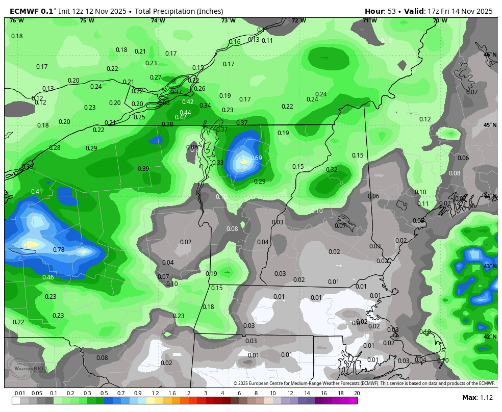
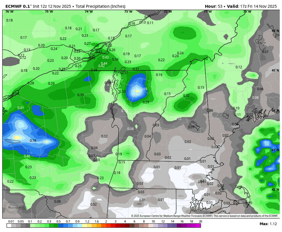
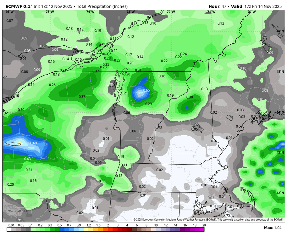
I can’t figure out what the Euro has been doing up here for two days, but it keeps putting some decent QPF overhead. Weirdly stable run to run. It looks like a standing wave or something. Past three runs… something to get Ray excited about.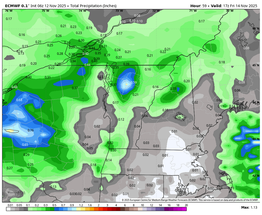
-
bz South now per space weather
-

2025-2026 ENSO
PhiEaglesfan712 replied to 40/70 Benchmark's topic in Weather Forecasting and Discussion
4 of the last 5 actually, as 09-10 was another strong el nino (along with 15-16 and 23-24). Very possible we could have a repeat of 86-89 (remember this came quickly after the 82-83 el nino), with the double el nino in 26-28, then transition to a strong la nina in 28-29. We're overdue for a strong la nina as well. We haven't had one since 10-11, which is the longest stretch without a strong la nina since 55-56 to 73-74. If we don't have a la nina by 28-29, we would have our longest stretch without a strong la nina since 1916-17 to 1955-56. -
Getting dinner out in Leesburg and hoping for progress in the next few hours.
-
I like seeing juicy Pacific systems come ashore near LA, as is progged for this weekend. When other conditions are right, those have produced some of our biggest snows about a week later. May that pattern continue into the coming colder months.
-

Central PA Fall Discussions and Obs
NepaJames8602 replied to ChescoWx's topic in Upstate New York/Pennsylvania
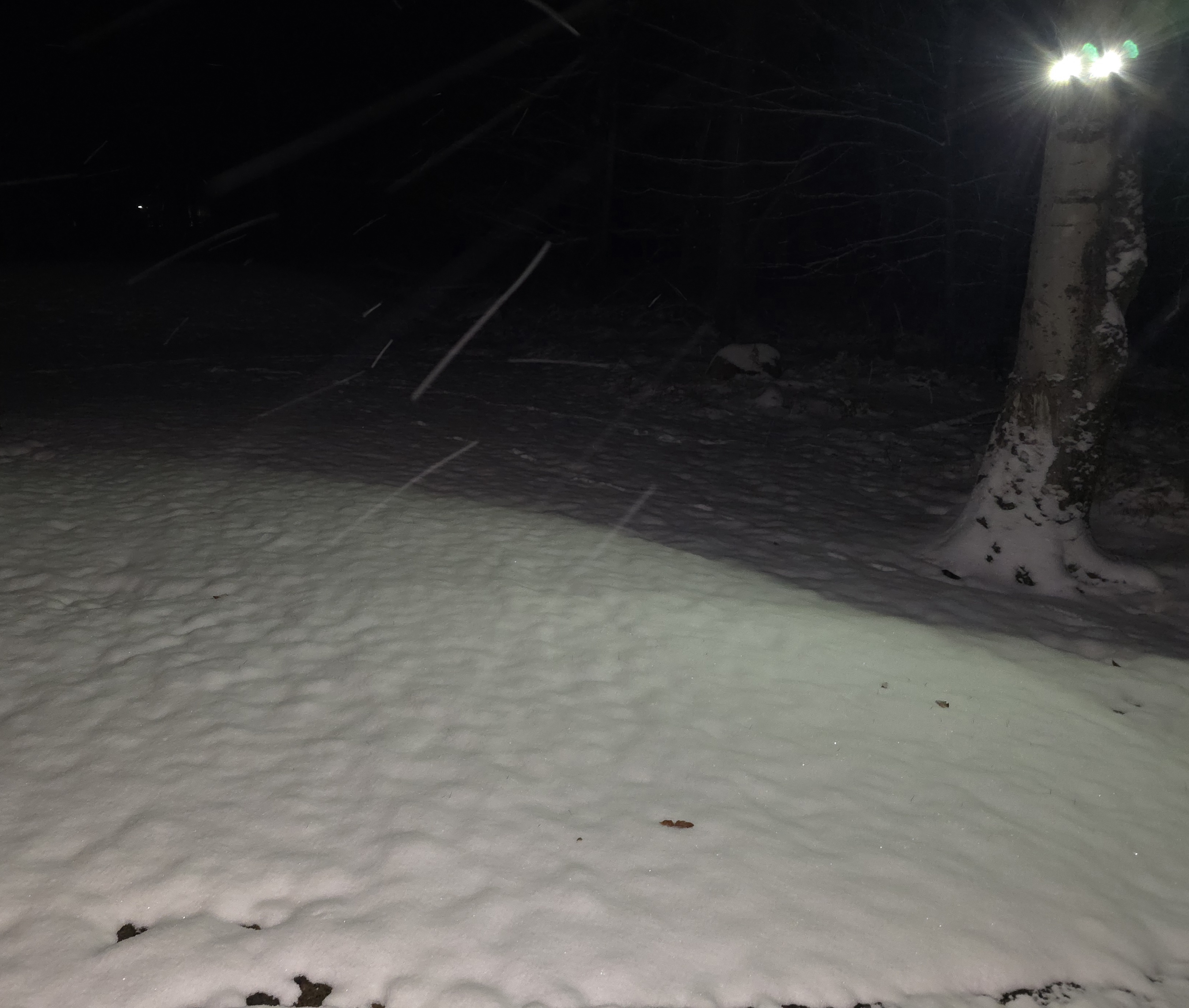
Hey everyone! Posted in the wrong forum last night lol. Anyways, I had my first snow accumulations yesterday from the les. I was at work all day, but checking my cameras it actually snowed all day. Didnt have much for accumulations at work near Scranton Pa. When I got home, a very different story in my part of the Poconos at 2,075' feet. Had about 2 inches on the grass and near 3" on my deck. Pretty much nothing on roadways. I was quite surprised regardless. Nice little event for Nov 11th. I Included a photo when I got home last night at 630 pm. Just saying hello to everyone and fingers crossed for a good upcoming snow season!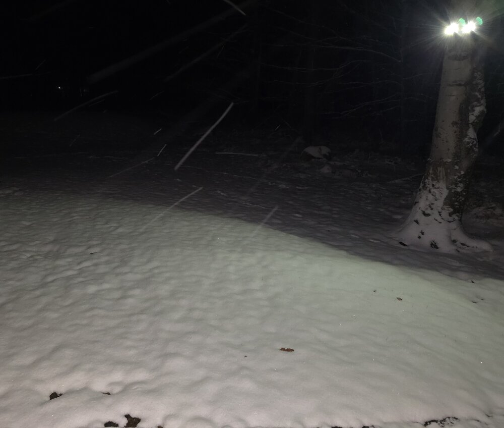
-
I think we all deserve a front, middle, and end loaded winter lol.
-
I got 89-90 also and 95-96. It’s interesting this season that a lot of occurred event analogs from this year are matching to positive outcome producing years in the past
-

2025-2026 ENSO
so_whats_happening replied to 40/70 Benchmark's topic in Weather Forecasting and Discussion
This is the wonderful thing of strong blocks and poleward flux. Ill have to take a look back and see what exactly caused the flow to buckle so much over the last 2-3 weeks. -

November 2025 general discussions and probable topic derailings ...
Snowedin replied to Typhoon Tip's topic in New England
I’m a little late on my end with this posting but man the turbulence coming in to providence airport early tues morning was just something else. We were already coming off a nearly 6 hour delay and wondering if we would even get home and that front meant business, just before landing. That sudden sinking feeling always sends shivers down my spine lol. Back to our chilly and windy reality for a while..heck of a time though seeing my crazy fam! -
Nothing yet, hopefully something pops within a couple hours
-

Central PA Fall Discussions and Obs
TimB replied to ChescoWx's topic in Upstate New York/Pennsylvania
So 6/106 (5.7%) from 1893-1998 and 5/26 (19.2%) from 1999-2024. Interesting. -

Central PA Fall Discussions and Obs
Voyager replied to ChescoWx's topic in Upstate New York/Pennsylvania
That's what I want... BTW, where are these showers coming from? Was it supposed to rain today? -
The weeklies H5 that Will posted is pretty ideal for small/moderate events. I dont really like big downhill/uphill patterns. Potential for bigger storms is better but lots of waiting and high risk of things not turning the corner in the right spot. The broader trough can be more active and shortwaves can get going much further west with good trajectory for the MA. TN Valley overrunners and things like that. In dec, big amplified stuff can often have temp problems too. Atlantic air moisture draw isnt nearly as friendly as Jan/Feb. Entrenched cold overrunning is easier to produce in Dec
-
Another good thread from @griteater. 2017 was the last year we had even respectable December snowfall.
-
For folks that want a front loaded winter. This one is for you
-

November 2025 general discussions and probable topic derailings ...
weatherwiz replied to Typhoon Tip's topic in New England
Correct, but that doesn’t necessarily mean anything for us. This could just as easily benefit Europe. But something to watch for sure -
And it's still below normal on 12/31.