All Activity
- Past hour
-
I was kidding but appears I'm right....sadly.
-
-
I bet .08 then eclipsing an old record
-
0.3?
-

Southern MD / Lower Eastern Shore weather discussion
AlexD1990 replied to PrinceFrederickWx's topic in Mid Atlantic
Moderate snow in Rehoboth. Sticking to grass, roads wet. at work so cannot measure. I'd estimate 0.5" -
Our cyclical climate change is doing it's thing! United States snow cover is now the highest it’s been in 20 years on Dec 5th! The Dec 5th snow coverage is 45.4%. The only higher year on record (since 2003) was 45.7% on December 4, 2005.
-
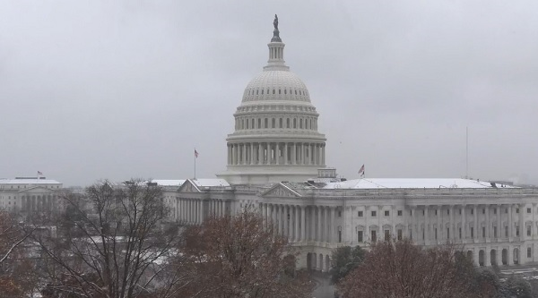
Source: Capitol Camera
-
I don't know, I can see Miley driving a low riding, customized Impreza
-
9.5° for the low here. Good bug killing weather
-
Overnight low of 10 here. If I had any meaningful snow cover it would have been colder. Just scattered trace amounts remain around here. Coldest NWNJ icebox spots with a few degrees of zero.
-
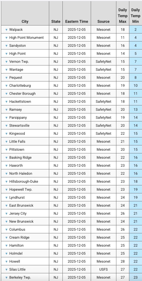
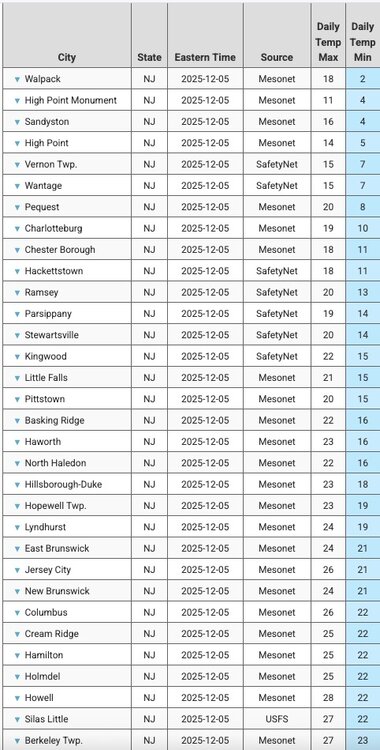
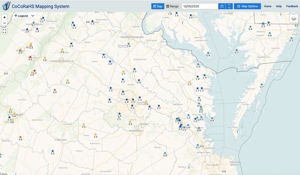
They reported 0.3" at 7am
-
1.3” in Potomac as the snow tapers off
-
The pattern in place is becoming deeply entrenched with the widespread deep snow cover across Canada and the tendency for the PV (or at least a piece of it) to want to sit over Hudson Bay. For a variety of reasons I think the general pattern in place now will want to stick around in some form for a while. I know the EPS weeklies have been insistent on shifting things west late in the month but I have my doubts, and even then the cold doesn't really go south it's mostly just in Canada. I certainly wish we could change some aspect of the pattern because otherwise my area stays dry. For me I need some help from the subtropical jet or for the polar jet to pull in a cutoff low when it breaks south. In ninas, I climatologically do better in January and February anyway so I guess we will see.
-
Cold look there. No doubt about that.
-
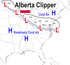
AI Overview Clipper weather refers to fast-moving winter storms, primarily the Alberta Clipper, which originate near Alberta, Canada, bringing rapid swings from cold to colder, light snow (1-3 inches), strong winds (30-50 mph), and biting wind chills as they sweep southeast across the U.S. Northern Plains and Great Lakes. While usually light, they can cause bigger snowfalls with lake-effect enhancement or if they intensify, sometimes becoming Saskatchewan Screamers or Manitoba Maulers (stronger variants). Key Types & Characteristics Alberta Clipper: The classic type, forming near Alberta, moving fast, bringing cold, wind, and light snow. Saskatchewan Screamer / Manitoba Mauler: More intense versions of clippers, often with more snow and stronger winds, developing over Saskatchewan or Manitoba. What They Bring Snow: Typically 1-3 inches, but can be 3-6+ inches, especially near the Great Lakes (lake-effect snow). Wind: Strong, gusty winds (35-50 mph) are common, leading to severe wind chills. Temperature: A noticeable and sharp drop in temperatures. Speed: Very fast-moving, often crossing regions in a day or two. How They Differ from Other Storms Colorado Low: Slower-moving systems that form in Colorado, often bringing much heavier, longer-lasting snow and blizzard conditions. Miller A/B Storms: Coastal storms that develop off the Southeast coast (Miller A) or the Gulf (Miller B), drawing significant moisture and potentially causing major Nor'easters, unlike drier clippers.
-
1.5” I’m happy
-
I’d prob extend that personally a bit to Xmas week. If we don’t have anything banked or imminent, then it would be another shaft job…..we have a chance this week before a little tiny relaxation (if it all), but then there’s clearly a reload for another favorable stretch doing into Xmas week. If we strike out on both periods, then we’re just living in the late 1980s/early 1990s paradigm again.
-
Trace of course
-

Central PA Fall Discussions and Obs
Itstrainingtime replied to ChescoWx's topic in Upstate New York/Pennsylvania
One common theme (at least it seems this way) that continues this season for southern tier folks is snow falling both north and south of us before we get into the action. Some nice pics coming out of MD/VA this morning. The sky certainly has the snow look down here. Reminds me very much of 1970s/early 1980s winters when areas south repeatedly cashed in while I wallowed in my tears. -
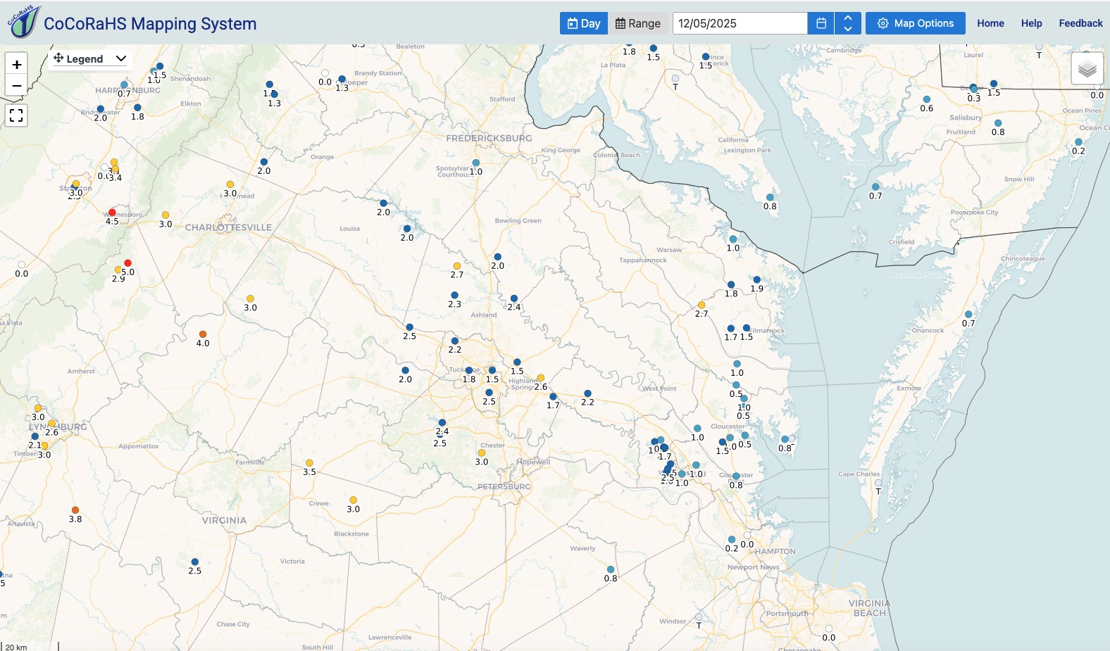
Most stations on this map have more snow season to date than my location. Currently .50" on the season here.
-
I think KMPV might have hit a record low for 12/05. NOWData has it at -7° in 1971 and it got down to -8° this morning.
-

Central PA Fall Discussions and Obs
Mount Joy Snowman replied to ChescoWx's topic in Upstate New York/Pennsylvania
You are probably right that his career is damaged because of the things he said about other schools and people, but I actually came across kind of liking him more haha. Fascinating to listen to, just hashing everything out with real talk. Sounded like totally normal stuff people would say when having what they think is a private conversation. Speaking of which, the bigger issue here is whoever released that (likely a player) committed a serious crime (I believe a felony?). Pennsylvania has very strict two-party consent laws about releasing private conversations. That's despicable behavior by whoever did it and will likely scuttle what was left of whatever chance they had to hire someone decent. I felt almost dirty listening to it, knowing it was meant to be between only the people in that room. A total violation of trust, and again, criminal behavior. -

Winter 2025-26 Short Range Discussion
madwx replied to SchaumburgStormer's topic in Lakes/Ohio Valley
shift back south on 12z and drying out, especially east. HRRR is the only one that stays north and juiced. -
Now we wait to see what DCA reports when all is said and done.
-
Too dry-probably some virga


(002).thumb.png.6e3d9d46bca5fe41aab7a74871dd8af8.png)