All Activity
- Past hour
-
I drove around a bit today. Main roads are fully cleared. Some of the secondary roads aren't always wide enough for 2-way traffic, but passable. Whatever it is they were trying to in the vicinity of the Ronkonkoma LIRR station around 1pm was utter chaos, absolute amateur madness. Also defies imagination that they would plow Union Ave last. It's like a city Avenue. I drove from Sunrise up to 25A in Stony Brook on Nichols Rd. There was more snow near Bellport than in Stony Brook but it's hard to gage how much from the car on a sunny late winter day.
-

Winter 2025-26 Short Range Discussion
sbnwx85 replied to SchaumburgStormer's topic in Lakes/Ohio Valley
South Bend picked up 9.2" from Sunday/Monday's lake effect snow event. That brings the seasonal total to 91.1". It is the 11th snowiest winter in South Bend history. Monthly Total Snowfall for South Bend Area, IN (ThreadEx) Click column heading to sort ascending, click again to sort descending. 1977-1978 0.0 0.0 0.0 0.3 30.3 33.6 86.1 16.6 5.1 T 0.0 0.0 172.0 1981-1982 0.0 0.0 0.0 0.1 9.1 41.3 41.3 19.2 10.2 14.0 0.0 0.0 135.2 1976-1977 0.0 0.0 0.0 0.8 21.6 37.6 37.2 13.9 15.8 2.3 0.0 0.0 129.2 1966-1967 0.0 0.0 T T 16.2 18.2 30.4 31.6 11.3 2.9 0.0 0.0 110.6 2013-2014 0.0 0.0 0.0 0.3 11.2 18.5 46.6 19.7 11.8 1.1 0.0 0.0 109.2 2010-2011 0.0 0.0 0.0 0.0 1.3 23.6 53.8 25.5 1.4 T 0.0 0.0 105.6 1962-1963 0.0 0.0 0.0 8.6 3.0 41.9 16.4 21.7 10.4 0.5 0.0 0.0 102.5 1978-1979 0.0 0.0 0.0 0.0 7.5 26.4 45.1 15.9 6.3 0.1 0.0 0.0 101.3 1959-1960 0.0 0.0 0.0 0.0 11.1 8.7 12.4 28.3 33.9 0.7 T 0.0 95.1 2017-2018 0.0 0.0 0.0 T T 32.4 22.0 29.6 7.6 1.5 0.0 0.0 93.1 2025-2026 0.0 0.0 0.0 0.0 27.1 10.0 38.6 15.4 M M M M 91.1 At home, I picked up 4.8", bringing my season total to 75.6" This ties my personal record for the snowiest winter of my life. Congrats to me. -

"Don’t do it" 2026 Blizzard obs, updates and pictures.
weatherwiz replied to Ginx snewx's topic in New England
There was no way to measure but I am figuring probably 6" or so. There were some totals around here that were a bit more than that. I thought I would get around a foot here (maybe closer to 18" if the banding worked right). I expected to get screwed but not this much. One of the biggest killers (outside of being in between bands) was the snow ratios absolutely sucked. Lift was definitely above the DGZ (which was also shown well on bufkit for this area). I'm honestly more mad CT wasn't widespread 18-24" than I am missing out -

Central PA Winter 25/26 Discussion and Obs
Blizzard of 93 replied to MAG5035's topic in Upstate New York/Pennsylvania
Lol, come on now, I went lower than many in the January storm forecast contest for MDT & won it with my 12.5 guess. You would have won the contest this time if we had done one this past weekend. I look forward to the next chance! -
Copernicus Marine showed a 76 (!) ZJ jump in OHC in '25. It's a much more volatile data series than the others, but even the smoothed IAP, etc showed ~24ZJ. Just for reference, if you plug 76 ZJ into the top 400m of the global ocean, you get +0.13C. That's oversimplified ofc, but gives you an idea of just how much heat we're dumping into the ocean. IAP's ~24ZJ gives you 0.14C if isolated to the mixing layer +1 y of extension via diffusion. And the implied EEI from that is about +1.5 W/m2. So these temp increases we're seeing at least seem plausible. We'd better hope these rates slow down, because we're talking pretty extreme rates of ocean surface warming which ofc will translate to even higher land surface temp rates. The fact that we can print a 1.44 W/m2 figure at these already very high temps is giving me some serious pause.
-
Please, I'm tapped out.
-

"Don’t do it" 2026 Blizzard obs, updates and pictures.
ORH_wxman replied to Ginx snewx's topic in New England
I remember posting in the lead-up to this event that the arc of convective snows was really catching my attention since it gave some of us instant flashbacks to April ‘97. It’s just a Firehose of convective snow streaming in from the ESE. But once the whole system trended a bit SE, the orientation changed enough to put far SE MA and much of RI in the cross hairs. We got the snow rates…it doesn’t take much imagination to think how this might have performed if it was 50-100 miles northwest like many runs had shown until the last 18-24 hours leading into the storm. That monster firehose being enhanced by convective elements would have been shot across a much larger chunk of SNE. Probably a more zonked system overall too if it was further NW. Still a great storm overall but that’s why those region-wide all-timers are so rare. You need things to line up. This one was so close though. -
Central PA Winter 25/26 Discussion and Obs
Blizzard of 93 replied to MAG5035's topic in Upstate New York/Pennsylvania
I think we have a long way to go until true Spring arrives this season. We have a few potential Winter events to track through next week. Then, we likely warm up for a week to 10 days. After that, the Teleconnections & MJO forecast indicate that mid March through at least early April could be a return to a colder pattern with the trough in the east. I think we are tracking Winter storm chances through Easter week in early April this year. It fits the same pattern that we have had since around Thanksgiving. Any warm ups have been brief & i think that continues. -
Time to wrap this thing up and call it a season.
-
15.6 is super early too at 10:45AM. it was still snowing well after that. ill just use yours
-
Rooting for you guys further south! I love snow like any other weather weenie, and it was wonderful to watch PVD smash their previous record. However, when you are an essential worker and you need to travel in this stuff, it changes your perspective a bit.
-

"Don’t do it" 2026 Blizzard obs, updates and pictures.
vortex95 replied to Ginx snewx's topic in New England
Is weatherwiz "mad" he only got, what, 10" total???? -

Clipper Fires In Wednesday Feb 25 Disco/ Obs
NoCORH4L replied to Damage In Tolland's topic in New England
2" is meh. 4" during rush hour is closure. -
We got us a Winnah.
-

Outta gas and Outta Time: Early March Winter Storm finale
Solution Man replied to Ji's topic in Mid Atlantic

-
Similar here. The intangible for me is the lack of qpf. Until last Friday/Saturday there wasn’t much meat in the pack.
-
its getting tossed, i have no idea why they included it. Nothing around it supports that kind of amount. Could just be a mis-entry
-
I just didn't understand why you said "Ryan's" like that was his map, what does Ryan have to do with that map?
-
"Don’t do it" 2026 Blizzard obs, updates and pictures.
ORH_wxman replied to Ginx snewx's topic in New England
Ginxy has the same longitude as ORH but far enough inland and elevated to avoid a lot of the SE CT flatland problems with marine intrusion. Def a solid spot. He prob only averages a hair less than N Foster coop just up the road and a little higher. -
"Don’t do it" 2026 Blizzard obs, updates and pictures.
vortex95 replied to Ginx snewx's topic in New England
With this being said from CoastalWx, and him getting two 20"+ blockbusters in Weymouth in a month, I *never* want to hear him Cartman b*ticin' about no snow or saying "THIS BLOWS" again!!! Recall earlier this winter, "THIS PATTERN BLOWS" was said by him, even though it was much better overall for New England even early on w/ the big snows in Nov on Mt Mansfield. That should have set him on a more positive path for the odds of a good winter. -
The Presidential Range on a bluebird day after the coastal storm:
-

"Don’t do it" 2026 Blizzard obs, updates and pictures.
Ginx snewx replied to Ginx snewx's topic in New England
Wind and sun making forms on the deck rail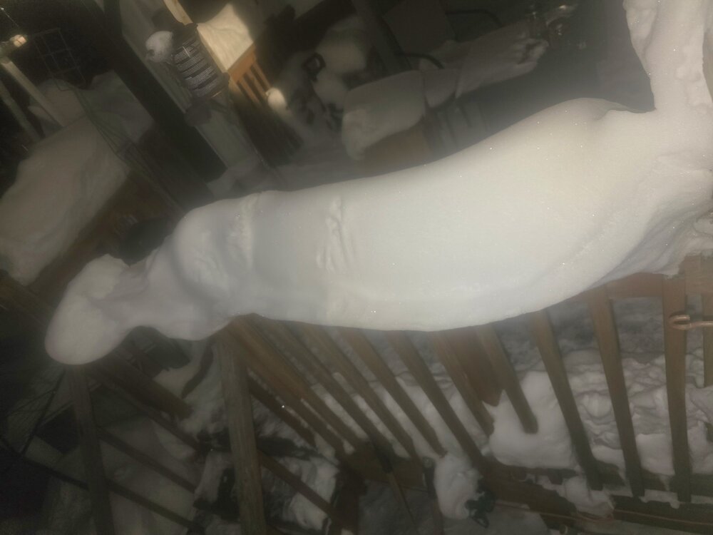
-

Clipper Fires In Wednesday Feb 25 Disco/ Obs
HoarfrostHubb replied to Damage In Tolland's topic in New England
BOX point and click mentions 2-4” I take the under -
That 21" in Andover looks little high/suspect. Here in Wilmington there was about 13"-14" (according to my best measurements) Wakefield had about 18" and the other spotter down Wilmington Road near Pinehurst had 15.2".
-

2/24 - 2/25 Clipper Obs (1 - 2" for many on forum)
Stormlover74 replied to Northof78's topic in New York City Metro
1/4"