All Activity
- Past hour
-
84 feels like 90 at 945am on the coolest day of the heat wave.
-

E PA/NJ/DE Summer 2026 Obs/Discussion
PhiEaglesfan712 replied to PhiEaglesfan712's topic in Philadelphia Region
If Derechoes happen, widespread 100s, and some places will get to 105, on Thursday and Friday. Remember in 2012, when this area got widespread 100 and DC got to 105 after the Derecho. -
 Interestingly, according to AI/the internet 72 F is the record high. I was curious what it was as we were up top one day in 2009 (maybe?) and it was stunningly beautiful, 68 F and still some snow piles in the parking lot. Got some pics of it around here somewhere.
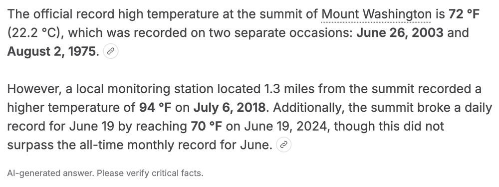
-
 I recall back in my UML days ... 72 F(~21 C) on the rock pile was a useful metric/threshold for hundo at Logan in WNW classic transport heat scenarios. Not sure if this true over all and SW flow types, but I don't see why not ... provided any south coastal oceanic contamination doesn't take place. Preferable to keep the winds less backed that 240 deg (260 down near Scott...) etc
 -
No guarantee it gets that hot down here (Ft Worth) this summer.
-
 Yup
Yup
-

Central PA Summer 2026 Discussion/Obs Thread
Mount Joy Snowman replied to Voyager's topic in Upstate New York/Pennsylvania
Welcome! Great story, I love all things Pine Creek related ha. -
GRR is at -1.4° below normal heading into the final day.
-
Corona, Queens is one of the prime spots for compressional heating.
-
2026-2027 Super El Nino
PhiEaglesfan712 replied to Stormchaserchuck1's topic in Weather Forecasting and Discussion
What if I told you that the coldest CONUS winter in the 21st century happened during a strong el nino year? And we did it with Nino 1+2 being close to neutral? But for there to be a cold winter in the Northeast or mid-Atlantic in a strong or super el nino, one would think the record warmth would be centered on the PNW or even southwest Canada (like in 2009-10, when record warm temperatures affected the Winter Olympics in Vancouver). Yeah, the only time a robust el nino held for two years was 1986-88, and that el nino dissipated quickly in the 2nd year, setting up the stage for one of the strongest la ninas on record in 1988-89. Prior to the mid-2010s el nino, it was almost a certainty that a strong or super el nino was followed by a strong la nina starting from 1972-73: 1973 - Yes 1983 - No (but we did get a multiple-year la nina, which peaked in the high weak/low moderate) 1988 - Yes 1992 - No (but a major volcano happened, and that might have screwed things up) 1998 - Yes, multi-year strong la nina 2010 - Yes Of course, 2016 and 2024 weren't followed by a strong la nina. Do we think it will happen 3 times in a row that we don't get a strong la nina after a robust el nino? -
Yeah, big heat coming. We are now under an Extreme Heat Watch (formerly 'Excessive Heat Watch') for Thursday morning through at least Friday evening.
-
No, just a couple fans to circulate the air and dry the sweat. Currently 71/71.
-
Amateur question here...Is that 70 Mt. Washington?
-
IYKYK... Even for someone like me who loves heat and humidity, that's just not fun for anyone.
-
lol what the hell is the criteria down there??? A heat advisory seems…insufficient.
-

2026-2027 Super El Nino
George001 replied to Stormchaserchuck1's topic in Weather Forecasting and Discussion
Depends on where you live. For my area weak El Niño is the sweet spot, and really weak ENSO is best (the top 2 ENSO states are weak El Niño and weak La Niña). ENSO has a pretty weak correlation though here. The only time I really lower expectations for winter due to ENSO here is if it’s a super Nino. I’ve been saying for a while I would rather roll the dice with a strong La Niña than a super Nino here. I would bet on the 27-28 winter producing more snow here than the 26-27 winter. All we really know for 27-28 is it won’t be a super Nino, since 26-27 will be and we don’t see multi year super ninos. I do think there is an elevated chance for a strong La Niña in 27-28 like @PhiEaglesfan712 is saying, but it’s not a guarantee. -
 GSPcountry joined the community
 -
Do you have any AC?
-
 Mr Senior joined the community
 -
Detroit is at -0.1F on the last day of the month so with the heat it will end up a few tenths of a degree above avg. Basically, a "normal" June anyway you slice it (generally +/- 0.5F is often considered "normal" by many). For me personally it has been a cool and very enjoyable June, due to the timing of my Alaska trip coinciding with our warmth early in the month and then my return coming with 2 weeks of below avg temps.
-
 Zen Blue joined the community
 -

2026-2027 Super El Nino
michsnowfreak replied to Stormchaserchuck1's topic in Weather Forecasting and Discussion
I could be wrong, but I believe a strong El Nino is traditionally better compared to avg for Colorado than it is in the east. Plus of course, we know how Denver can rack up September and May snow with 70F in January . While measurable snow is normal here in the Detroit area from November thru April, its a more traditional curve, with the snowiest month being January followed closely by February (each month over 12"), with both November and April each averaging just under 2". A common trend seen in strong El Ninos is well ABOVE avg snowfall in November, followed by below avg snow in December. Once you get to January results get more mixed. -
 I'm not buying that at IK in the woods. 95 seems more doable.
 -
 This is rare for this area. Not sure it works this way
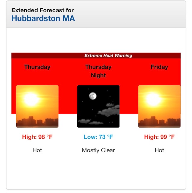
-
Dews will be dewlicious
-
 JohnnyH95 joined the community
 -
Analyzed everything from the 00z GFS/Euro/Canadian. En masse/holistically the Wed-Sat heat wave was modestly more intense by potential 1-3 F max (which situates higher nocturnals) than the previous two or three model cycles. Emphasis on 'modest'. Because none of these model run/analysis going back several days at this point have deviated significantly from a general motif of being near or at upper bound heat event, it's unlikely to register as much of a sensible human difference. 97 or 101, you're not feeling that change particularly if the DP varies by some ( HI's may vary). Extremist was GFS at 101/102's common from D.C. to Metro West Boston. Contrasting upper 90s from the GGEM. Euro's low balling Wednesday I feel ...otherwise might be a decent compromise. Hard to really pick one over the other. I don't see many limiting factors on this 00z cycle, across the board. All three have off-shore light winds under 21 to 23C 850s, with 300, 500, and 700 sigma level RH fields well below materialized cloud numbers ( ~60%), implying ample solar. The only thing we're missing here is truer longevity, where it cycles between an interim relaxation followed by resurge over a 7 to 10 day memory maker. That could materialize in future guidance, but for now ... the index floor doesn't appear to be as favorable for that. However, there are no huge cooler corrections signaled, either. The indices are more neutral - keeping in mind that they are less useful in summer. And the Euro and GFS have typical autumn troughs erroneously over Hudson Bay... which are not mass-field supported, nor demoing any continuity, run to run. The heights locally stay in the 582 dm range, either way, which connects to climo as AOA Impressive heat wave as is. Seldom do I recall - if ever - two days back to back on MEX with 101 at KFIT. This event has some bulk. Usually we're 94 for 4 days with one day to 99 typology. Not sure what our climatological "normal"/seasonal heat wave is but I know we don't typically succeed 100 two days running save for some rare historical events. We'll see where this lays out.
-
Last year or 2022 for many in NJ
-
For EWR: # Days When 5 Jul 20–24, 2022 4 Jul 4–7, 2010 4 Jul 7–10, 1993 4 Aug 28–31, 1953 3 Jun 23–25, 2025 3 Jul 21–23, 2011 3 Aug 1–3, 2006 3 Aug 7–9, 2001 3 Jul 2–4, 1966 3 Aug 9–11, 1949 3 Jul 28–30, 1949