All Activity
- Past hour
-
Interesting... Special Weather Statement National Weather Service Baltimore MD/Washington DC 410 PM EDT Sun Aug 16 2026 MDZ509-510-162130- Eastern Garrett-Western Garrett- 410 PM EDT Sun Aug 16 2026 ...A LINE OF SEVERE THUNDERSTORMS IS APPROACHING GARRETT COUNTY... At 405 PM EDT, radar indicated severe thunderstorms were located along a line extending from near Jefferson Boro to near Cassville to Monongah to near Enterprise. Movement was east at 50 mph. Locations impacted include... Mountain Lake Park, Oakland, Bayard, Bittinger, Grantsville, Loch Lynn Heights, Friendsville, Deer Park, Accident, Redhouse, Hutton, Gorman, Jennings, Crellin, Deep Creek Lake State Park, Swallow Falls State Park, McHenry, Big Run State Park, Piney Grove, and McComas Beach. This includes Interstate 68 in Maryland between mile markers 1 and 30. Frequent cloud to ground lightning is occurring with this line of storms. Lightning can strike 10 miles away from a thunderstorm. Seek a safe shelter inside a building or vehicle. If you are on or near Deep Creek Lake, be preapred to take swift action to get out of the water and move indoors or inside a vehicle as storms approach. Remember, lightning can strike out to 10 miles from the parent thunderstorm. If you can hear thunder, you are close enough to be struck by lightning.
-

2026 Mid-Atlantic Severe Storm General Discussion
Eskimo Joe replied to Kmlwx's topic in Mid Atlantic
Also a heavy precip disco for our far western posters: -
2026 Mid-Atlantic Severe Storm General Discussion
Eskimo Joe replied to Kmlwx's topic in Mid Atlantic
Definitely looking like a non zero tornado threat west of US 15 this evening. Mesoanalysis and mesonet data showing some nice backing of winds and surge in dews.- 1,941 replies
-
- 1
-

-
- severe
- thunderstorms
- (and 7 more)
-

2026-2027 Record-breaking El Nino
jaxjagman replied to Stormchaserchuck1's topic in Weather Forecasting and Discussion
PDO is gonna fluctuate by the tropical PAC,strong WWB along with Rossbly Waves its gonna get quite active in the PAC the next few weels.Last thing is wanna see is another typhoon hitting East China,which seemingly might happen again -
Rinse repeat....poof when everything approaches wake co.
-
These showers are fizzling out faster than the panthers offense in the 4th quarter.
-
(002).thumb.png.6e3d9d46bca5fe41aab7a74871dd8af8.png)
Central PA Summer 2026 Discussion/Obs Thread
ChescoWx replied to Voyager's topic in Upstate New York/Pennsylvania
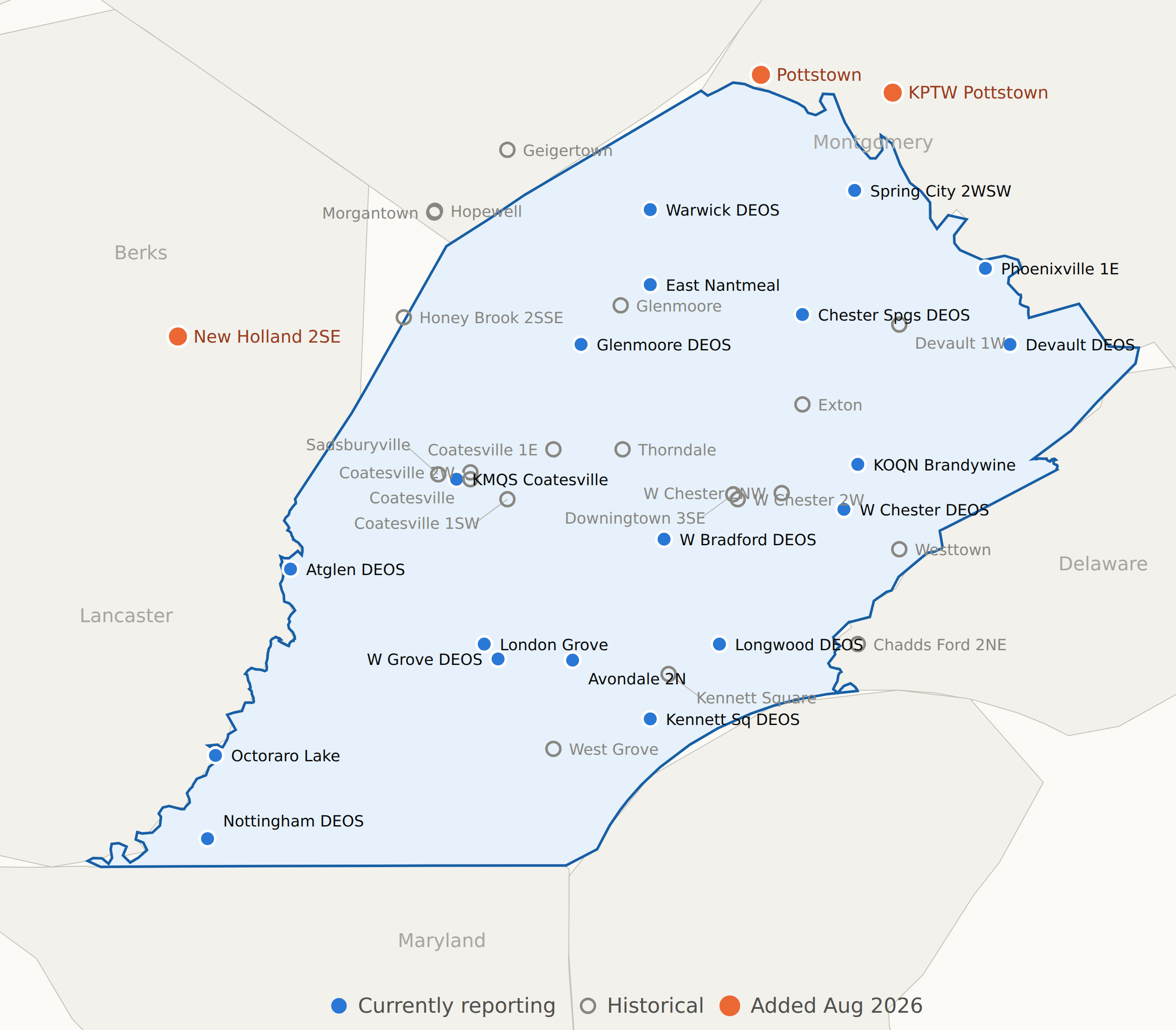
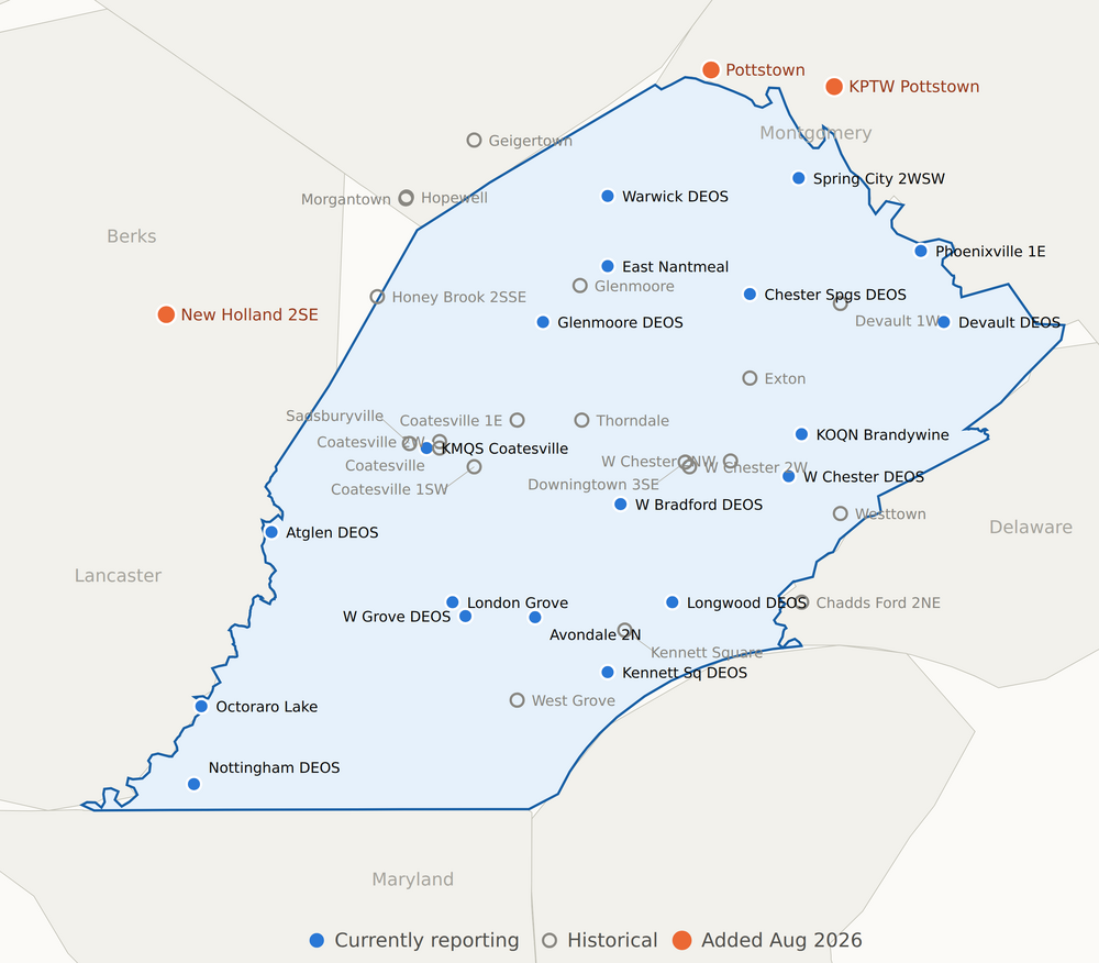
Just an FYI for those that may be interested.I have added a few additional stations to join the few we already have included that are while not in Chester county are close to the Chester County border and meets our area description. Some are only historical like NWS COOP locations for Pottstown which has precipitation and snow only while New Holland NWS COOP in Lancaster County is temperatures, precipitation and snow. Below are all stations not in Chester County - some are as close as 400 feet such as at Octoraro Lake , All other stations with the exception of New Holland are within 2 miles of the Chester County border. Also attached is a map with all current and historical stations included for reference.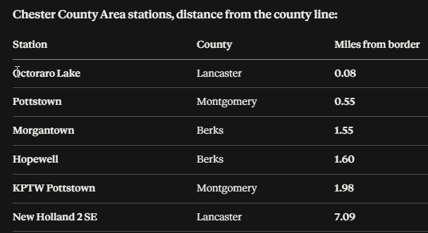
-

Augdewst 2026: Summer's Last Stand
Baroclinic Zone replied to Prismshine Productions's topic in New England
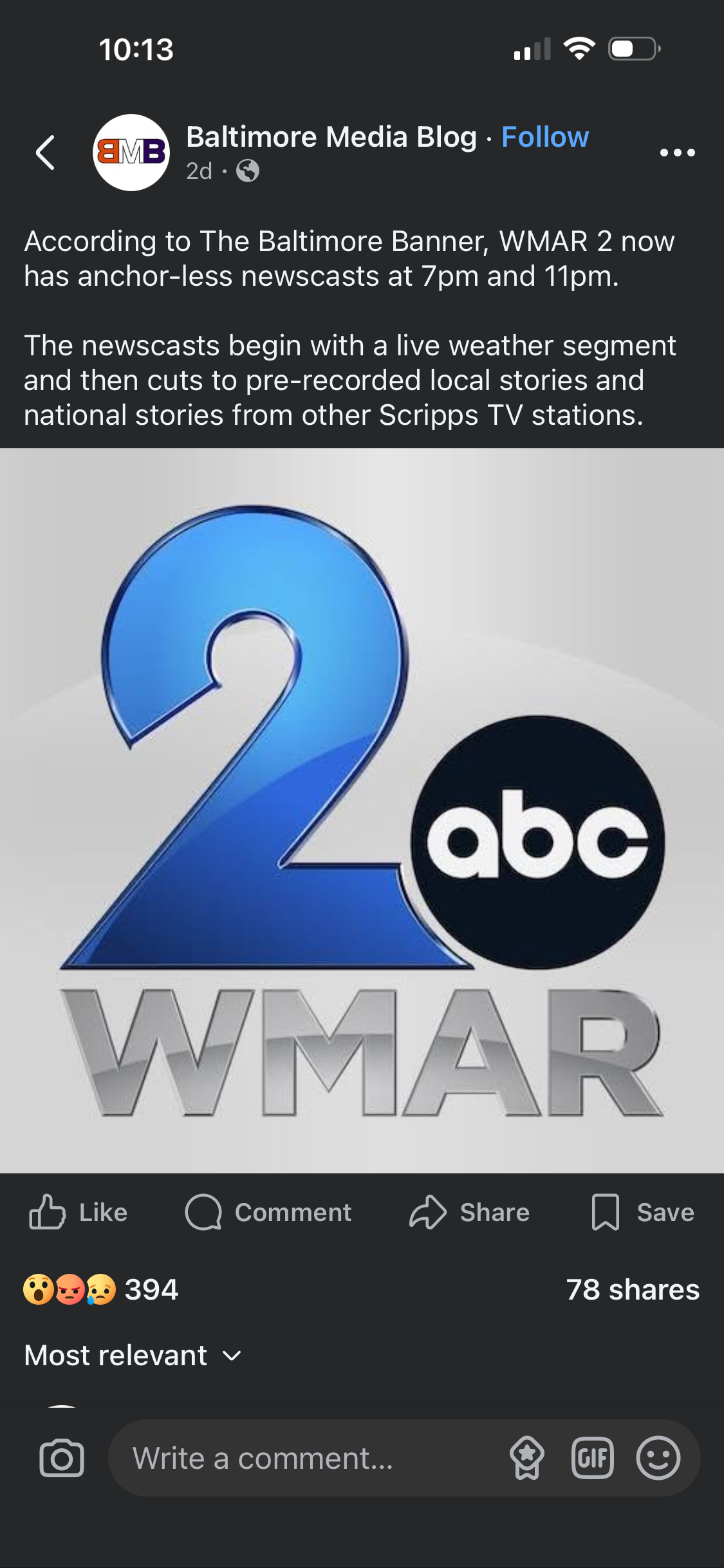
Corporate ownership does not care. Bottom line is $. If they can cut spending on newscasters they will. AI is going to make a lot of current occupations obsolete. -
Mesoscale Discussion 2000 NWS Storm Prediction Center Norman OK 0228 PM CDT Sun Aug 16 2026 Areas affected...south-central Pennsylvania...the Maryland and West Virginia Panhandles...and northern Virginia Concerning...Severe potential...Watch likely Valid 161928Z - 162130Z Probability of Watch Issuance...80 percent SUMMARY...The threat for severe storms capable of mainly damaging wind gusts is expected to increase late this afternoon into evening. A severe thunderstorm watch is likely. DISCUSSION...In the wake of an MCV moving from south-central into southeast PA, clouds are gradually clearing, allowing for increased diabatic heating this afternoon. When coupled with a moist boundary layer characterized by boundary-layer dewpoints in the upper 60s to mid 70s F, latest objective analysis indicates MLCAPE of 1000-1500 J/kg with decreasing convective inhibition. Additional air mass destabilization is expected through the remainder of the afternoon, allowing ongoing QLCSs to spread east into the discussion area. Damaging wind gusts will be the primary hazard with the most intense storms, especially in the vicinity of any embedded bowing structures that may persist. A brief tornado or two is possible in areas that can maintain more of a southerly wind component, where low-level shear is locally enhanced. ..Mead/Guyer.. 08/16/2026 ...Please see www.spc.noaa.gov for graphic product... ATTN...WFO...AKQ...CTP...LWX...RNK...PBZ... LAT...LON 38357955 38947931 39407927 40267895 40477848 40397801 39307761 38237782 37877812 37537857 37497918 37897993 38357955 MOST PROBABLE PEAK TORNADO INTENSITY...UP TO 90 MPH MOST PROBABLE PEAK WIND GUST...55-70 MPH
-
E PA/NJ/DE Summer 2026 Obs/Discussion
ChescoWx replied to PhiEaglesfan712's topic in Philadelphia Region
Just an FYI for those that may be interested. I have added a few additional stations to join the few we already have included that are while not in Chester county are close to the Chester County border and meets our area description. Some are only historical like NWS COOP locations for Pottstown which has precipitation and snow only while New Holland NWS COOP in Lancaster County is temperatures, precipitation and snow. Below are all stations not in Chester County - some are as close as 400 feet such as at Octoraro Lake , All other stations with the exception of New Holland are within 2 miles of the Chester County border. Also attached is a map with all current and historical stations included for reference.
-

Augdewst 2026: Summer's Last Stand
Brian5671 replied to Prismshine Productions's topic in New England
it's a dying entity like FM radio-young adults under 30 are unlikely to watch a TV newscast.....I'm guessing the viewership right now skews older. Another 10-20 yrs and alot of those folks will be gone without anyone to replace them. TV anchors/personalities are expensive so with declining ratings I can see why they are doing the above. -
Watch coming shortly... looks like for i95 corridor westward https://www.spc.noaa.gov/products/md/md2000.html
- 1,941 replies
-
- 1
-
-
- severe
- thunderstorms
- (and 7 more)
-
Augdewst 2026: Summer's Last Stand
Baroclinic Zone replied to Prismshine Productions's topic in New England
Dew drop in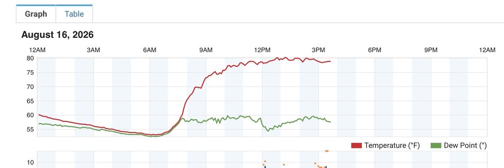
-
Augdewst 2026: Summer's Last Stand
Baroclinic Zone replied to Prismshine Productions's topic in New England
Amazing song. Made some great music post Dio. -

Central PA Summer 2026 Discussion/Obs Thread
Superstorm replied to Voyager's topic in Upstate New York/Pennsylvania
0.79” so far . -
Nothing is guaranteed just because we are having a Nino. October, November and December of 1965 experienced a strong Nino at +2.0 A severe drought was in progress. Dulles received a total of .46" during November of 65. December of 65 was worse at only .42"! The heavy snows of late Jan. 66 finally brought moisture.
-
Big Gulf lows moving up the coast with long-duration soaking rains. It will be dreary, but we need it!
-
 https://mencarevirtual.shop/# MenCare Sildenafil Citrate Tablets 100mg
 -

Augdewst 2026: Summer's Last Stand
vortex95 replied to Prismshine Productions's topic in New England
See X post attached. The Baltimore TV market is not tiny and this is a major network affiliate, not cable or independent! And owners don’t seem to understand that many ppl watch local news for the anchors! Pre-recorded segments? You can get that anywhere. But at least they have live wx still. The wxcast is the number one reason why ppl watch local news. Yes, I understand the economics and how the business is evolving but it is still not good. I have noticed since the advent of widespread AI-generated content several years ago, there is a strong backlash and stigma now in much of the population, and it is not just older generations. "AI Slop" as a term has becomes mainstream. Funny, when CGI first became big in the 90s, that did not have nearly as much pushback, probably b/c you still actually had ppl as actors and you knew they were real. Now? It has gone into "uncanny valley" territory. Ppl do not know what is real or fake now, and that fundamentally raises alert/suspicion in our minds. I think some smaller TV markets have already done this, but as noted, Baltimore is not a small TV market. Has it happened anywhere for New England markets yet?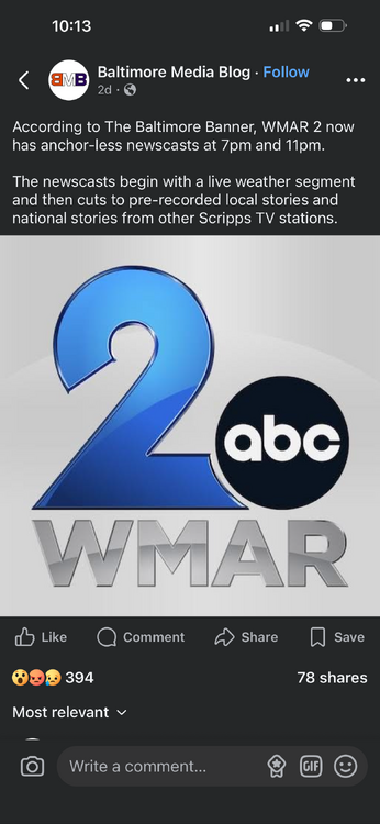
- Today
-
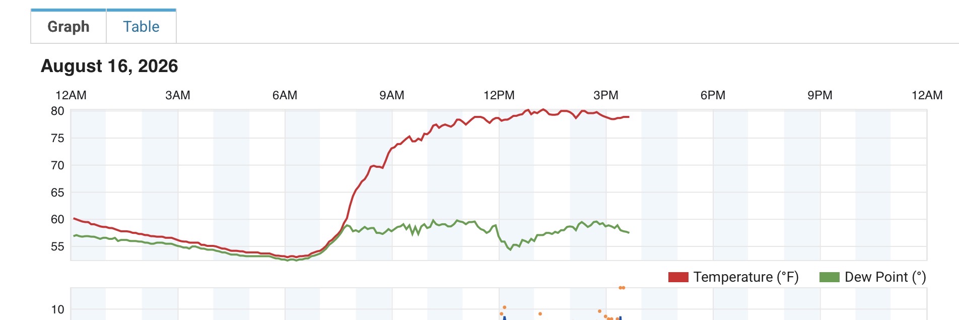
98F/ 78 dew. Feels like 115. Watching the storms arriving from the NW doing their usual thing and falling apart as they hit the triangle.
-

Occasional Thoughts on Climate Change
gallopinggertie replied to donsutherland1's topic in Climate Change
Hong Kong recently broke its all-time high, during Typhoon Dolphin. Here is an excerpt from an environmental newsletter I receive, describing the day: “ Dear Reader, On Sunday, August 9th, the Hong Kong Observatory recorded a temperature of 36.9 C (98.4 F), the highest since records began in 1884. I’ve often told my friends stateside to imagine Hong Kong’s normal summer climate as “Houston on steroids.” This past Sunday was something else: I was breaking into a sweat just standing in the shade waiting for the bus. There was no breeze, and you could feel the heat radiating into your body, as if you stepped into a sauna. In fact, the “feels like” temperature reached 46 C (114.8 F) — hotter than Houston, Miami, or Phoenix.” -
The .47" received today is the most from 1 event since July 21.
-
Bold prediction: The Os never get above .500 and miss out on the final WC spot by one game
-

Augdewst 2026: Summer's Last Stand
Damage In Tolland replied to Prismshine Productions's topic in New England
Dews have come up nicely. A bit swampy as we mow -
The line is already there in ern OH (looks like a LEWP), so the HRRR is not creating the mini-bow echo from nowhere. HRRR has a couple of cells before the bow, and then clusters after it! My kind of tstm day!
- 1,941 replies
-
- 3
-
-

-
- severe
- thunderstorms
- (and 7 more)