All Activity
- Past hour
-
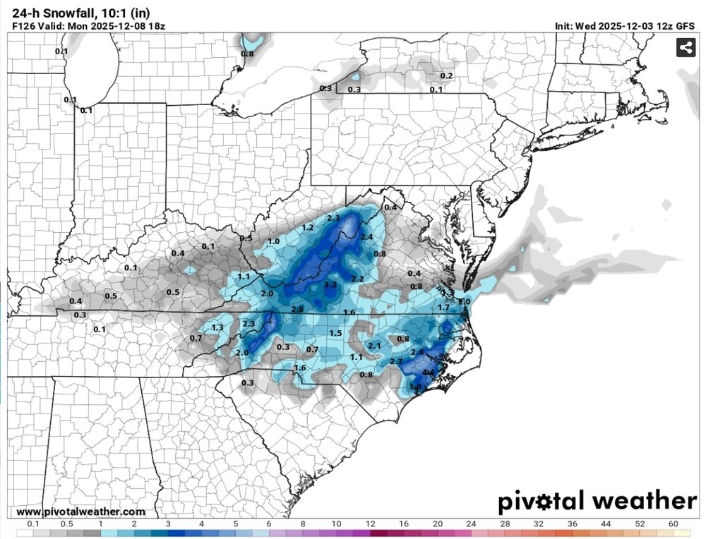
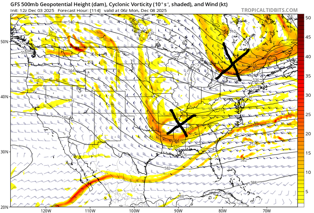
I don't think it's a mirage...the setup has the potential for an actual snowstorm. We need the timing of a northern stream wave to change. If it does...and asking for that kind of change at this range is not crazy...the setup is there. That doesn't mean, of course, we will get the changes we need...but I don't think the threat is dead yet. 12z GFS The problem is there is a wave coming across right on top of the potential system as it's entering the TN Valley...suppressing it right at the critical moment for our purposes. If that wave to our north is 12 hours further along...there might be room...if it is 12 hours further behind...it opens the door to a phase in a helpful way instead of a suppressive impact. There are options here that very reasonable changes to this depiction could very easy result in snow for our area. Most of the ingredients we need for a snowstorm are right there...with just one thing we need to get out of the way. I wouldn't give up on it yet.
-
12z CMC blossoms light snow on Monday similar to 12z GFS. The GFS finally has someone tag along with it for Monday
-
You could see it a bit through there on the fringes of ENX and GYX for a few hours. Definitely a fun event. Deep winter and Christmas vibe out there right now.
-

December 2025 regional war/obs/disco thread
weatherwiz replied to Torch Tiger's topic in New England
One of the courses I have to do is a climate change course (well I think its an elective but I'm going to take it). Looking forward to that. Haven't read the info on it yet though so not exactly sure what would be covered. -

Winter 2025-2026 Offers Return to Normalcy
Typhoon Tip replied to 40/70 Benchmark's topic in New England
Thing is ( not to be difficult ...great write up!), I'm not sure it was a poorly modeled warm layer? I mean, maybe it was that the layer is not exposed in the products we're allow to see? I'm asking because maybe we can back into an excuse for this. Namely, the modeled PTYPEs were excessively wet as opposed to white. That was a bit of a head-scratch when given the low path was S of LI, while also antecedence was so cold in the interior - and actually the coastal plain wasn't exactly warm, either. In other words, something in the ptype algorithms must have been seeing a phase change from white to wet despite those observations above. I remember remarking the day before that a possible compromise might be a lot of freezing rain in a band between HFD and BED ..etc. Nailed that! well... I don't mean to take credit, it's just that both things could be true. Warm layer we weren't aware, because the products didn't expose, but it may have still been there, while the cold llv was poorly handled by guidance and so icing resulting. I will say, didn't see a lot of ZR in the ptype forecasts. It was a really narrow IP band separate all snow and all rain. Almost no IP actually... That was definitely seemingly off to me anyway - -

Central PA Fall Discussions and Obs
Jns2183 replied to ChescoWx's topic in Upstate New York/Pennsylvania
Maybe this is the needed sacrifice for mother nature to finally open her legs Sent from my SM-S731U using Tapatalk -
Has he ever been?.
-
Canadian is a close miss south
-
All the 12z models have it so far.. looks like 1 to 2 if we get anything.. but we have also seen them before up or disappear
-
December 2025 regional war/obs/disco thread
Typhoon Tip replied to Torch Tiger's topic in New England
Nah...they'd hit at a tone of climate for modulation and correction aspects, a lot of which is no longer valid because ... heh, the climate (isn't) changing - wah wah wahhhh -

December 2025 Short/Medium Range Forecast Thread
Carvers Gap replied to John1122's topic in Tennessee Valley
I have hated to even say it out loud, but that scenario has been on modeling for days...just a bit to our SE. Now, things are trending a bit northwest. It is a narrow boundary for that to occur and a bit early in the season for the valleys, but I could see places above say 1800' scoring with this. -
4.5" here so far.

-
I don't usually let busts get to me anymore...but that one...yea that one...
-
December 2025 Short/Medium Range Forecast Thread
Carvers Gap replied to John1122's topic in Tennessee Valley
@Holston_River_Rambler, I do think the RGEM looks a bit too cold. Time of day is key I "think." For ice in the eastern valley, the cold air has to get trapped. Usually for that to happen, we need a clear sky to start the evening and temps drop. Then cloud cover slides over between 2-4AM and traps the cold air in the valley. I just am not sure. I do think SW VA looks prime for good snow as is SE KY and prob the Plateau if the precip can make it back that far. NE TN is a crap shoot. What interests me is the slp popping to the SE. -
Welcome to life as a Philly snow weenie. We're already playing "Not-This-Storm-But-The-Storm-After-The-Next-Storm-Will-Be-Our-Storm" Roulette
-

December 2025 Short/Medium Range Forecast Thread
Holston_River_Rambler replied to John1122's topic in Tennessee Valley
Based on what has happened with the Thursday night system, I think the 8-10th one is going to produce some snow from someone along and north of I-40, location in TN, NC, or VA to be determined Trend on the GFS for Thursday night: -

December 2025 Short/Medium Range Forecast Thread
Daniel Boone replied to John1122's topic in Tennessee Valley
Could be a rather long duration Event, combining the 2. Not saying anything like what I'm bringing up is possible this time but, for whatever reason made me think of one of Knoxvilles big, long duration Snowstorm Dec. 3-6 I believe way back in the late 1800's I read about. I think 1873. Would have to look it up. It was nearly 2 Feet ! I've often wondered if it was a product of overrunning or System or multiple Systems. -
I will be happy with just a ground coating here in Charlotte and hope we all get some snow ❄️
-

Fall/Winter Banter - Football, Basketball, Snowball?
nrgjeff replied to John1122's topic in Tennessee Valley
Good grief both Tennessee and Kansas lost last night. Tennessee almost caught 'Cuse multiple times - like stranding baserunners. Kansas simply had a blown save - arguably the most frustrating thing in all of sports. Indeed, the most frustrating thing in all of meteorology is cold air in place and the system goes south. Truly PUKE inducing! -
Two things can be true. The euro products are still the best, and if you can only have one thing in your corner that is the one you want...but the euro is not so dominant over all other guidance that it's typically right when it's all on its own. If that was true forecasts would just be a rip and read copy of the euro. A consensus between all the guidance is still typically more accurate than any one model. The real skill is knowing when one model "Might" be on to something that others are missing. Using experience and history and pattern analysis to try to figure out what the right weights are in each specific situation.
-

December 2025 regional war/obs/disco thread
Damage In Tolland replied to Torch Tiger's topic in New England
It wouldn’t be shocking to see this beef up a bit more as we get closer. We’ve seen these do that where you have an offshore storm and a N stream coming in -
I could see this as being the option that happens...
-
December 2025 Short/Medium Range Forecast Thread
Holston_River_Rambler replied to John1122's topic in Tennessee Valley
NAM looks to have come in a bit colder at 12z with a quicker precip onset for Thursday night. I'm honestly having a hard time believing what the RGEM is throwing out for MBY, but as Carver's will tell us, one disregards the RGEM for winter events at one's peril. I do like the RGEM, but: If there's a warm nose coming up I-75, I usually get it too. -
I think the Dec 1 - 10 mean and median calcs are off. Eyeballing the list, they should be in the 3" range.
-
This is just for Mondays possible event