All Activity
- Past hour
-
That HoCo/MoCo border area getting it again
-
clearing is headed this way for mid - late afternoon - temps will rebound to close to 80 or above in some areas but high humidity for awhile
-
If you get enough sun in between, I've experience double the fun before. What I miss are those nights where you get storm after storm. It seems like it thunders all night long. Best sleep ever.
-

Central PA Summer 2026 Discussion/Obs Thread
Storm Clouds replied to Voyager's topic in Upstate New York/Pennsylvania
Sorry about your bad experience! Mine was put to the test yesterday with that batch of storms that moved through. Even though I wasn’t home, I was getting plenty of lightning alerts and rain start notification. I have the Nearcast rain feature turned off to make sure I get the raw rainfall amount recorded for my backyard. It recorded .11 which correlates well with two other nearby stations…one recorded .12 and the other .15. So far so good! -
Heading to you're area in a few for a grad party. Hope it stops soon for it.
-
I remember feeling a little off the rest of the day after riding the ferry. If you’re anything like me, take a Dramamine.
-
Dropped .80” in Morristown - wasn’t expecting anything but will definitely take the moisture.
-
It always worries me when I get a pop up storm right over me this early in the day. It makes me feel like I’ll miss out on all the good stuff later.
-
Same. I'm still waiting to mow my lawn for the first time this year. Just random patches of green weed in a sea of brown.
-
 Dendrite has PTSD from last year’s drought.
 -
July 11 1903: The temperature plummets down to 26 at Leech Lake Dam. For Saturday, July 11, 2026 1888 - Heavy snow reached almost to the base of Mt. Washington, NH, and the peaks of the Green Mountains were whitened. (David Ludlum) 1987 - Early morning thunderstorms produced wind gusts to 90 mph at Parkston, SD, and wind gusts to 87 mph at Buffalo, MN. Later in the day strong thunderstorm winds at Howard WI collapsed a circus tent injuring 44 persons. (The National Weather Summary) (Storm Data) 1988 - Thunderstorms produced heavy rain in southern Texas, with totals ranging up to 13 inches near Medina. Two men drowned when their pick-up truck was swept into the Guadalupe River, west of the town of Hunt. Ten cities in the eastern U.S. reported record high temperatures for the date. Baltimore, MD, reported a record high reading of 102 degrees for the second day in a row. (Storm Data) (The National Weather Summary) 1989 - Afternoon and evening thunderstorms produced severe weather from North Dakota to Indiana. Thunderstorms in North Dakota produced tennis ball size hail at Carson. Thunderstorms in Indiana produced wind gusts to 75 mph at Fort Wayne. Five cities in the Southern Atlantic Coast Region reported record high temperatures for the date, including Lakeland, FL, with a reading of 100 degrees. (The National Weather Summary) (Storm Data) Observances: 11 Sat World Population Day 11 Sat World Essential Oils Day 11 Sat All American Pet Photo Day 11 Sat Cheer Up the Lonely Day 11 Sat International Essential Oils Day 11 Sat National 7-Eleven Day 11 Sat National Blueberry Muffin Day 11 Sat National Culture and Senior Citizens Day 11 Sat National Mojito Day 11 Sat National Rainier Cherry Day 11 Sat National Polyphenol Day 11 Sat National State Fair Food Day 11 Sat National Swimming Pool Day 11 Sat World Benzodiazepine Awareness Day 11 Sat Free Slurpee Day
-
there was an area of very heavy rain just to your east on radar - would like to hear of any amounts from those areas
-
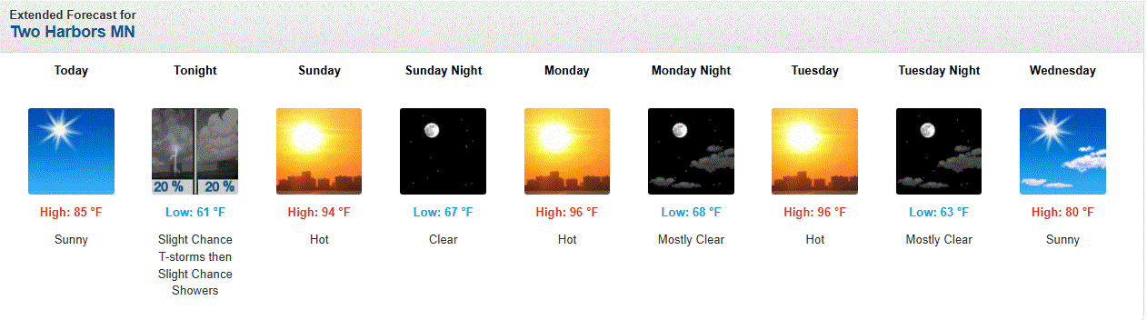
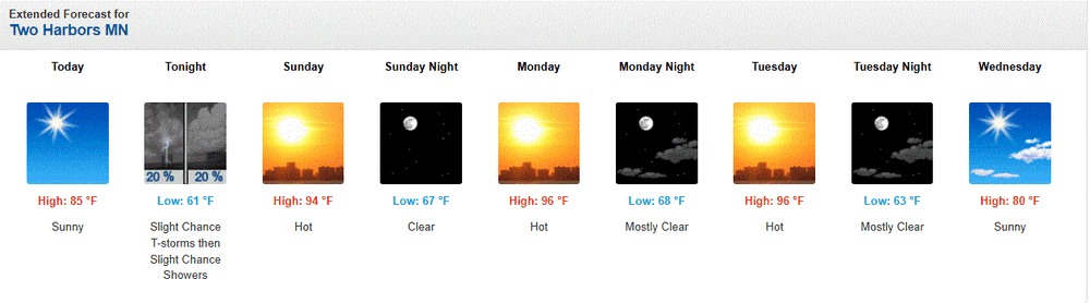
Heritage Days in Two Harbors started Thurs. Parade today will be starting soon. Right now temps in the upper 70's with a 65 dew. Mid 80's forecast for mid aftrn.
-
It produced a quick half inch of rain here. Moving slowly as you said, but it's a very skinny line so it doesn't last too long. It was absolutely torrential rain for a little while though. Happy to get the half inch today after the 2 inches the other day. It'll be good to go into the heat wave with high soil moisture.
-

Winter 2026-2027 Seasonal Outlook
WinstonSalemArlington replied to WinstonSalemArlington's topic in Southeastern States
-
They upped the temps the next few days from around 90 to mid 90's here in town. SW winds will bring hot air, along with some down sloping effect from the ridges. We'll see how this pans, but it'll be nasty without A/C.
-
1.2" from last night's thunderstorm line. Dark green weeds surrounding patches of brown grass. Summer in the MA.
-
 Feels like that wouldn’t even satisfy folks, as soon as the GFS shows a dry 7 days it’d be like a week of rain never happened.
 -
It's so damn soupy out there again today
-
The rain split my area and may or may not redevelop I guess. At this point, guessing is working as well as the models.
-
This line of heavy rain moving south from Northern NJ into Middlesex County is moving slowly and should produce an inch or 2 of rain in some places and wouldn't be surprised if there is more flooding in the usual areas prone to it. No wind thunder etc yet temp dropped from 83 to 69
-
Posted up in Columbia for the day and night, remaining vigilant
-
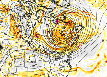
 question is ... how much of this survives an over-the-top delivery before the flow collapses into and around that autumn pattern later next week... Never seen sub 545 dm SPV over N Quebec, doing so in mid/late July nearing the perennial hottest time of the climate year, but the GFS is just getting more and more absurd ... not backing off, as we get closer. This 120 hours... uuuusally when the amplitude starts to normalize. We'll see tomorrow but jesus christ with this beast! Euro's 10 or so dm shallower but still depicting the highly anomalous SPV, too. It's not just that ... the west-NW Euro heat wave and associated ridging is paradoxical to that. The teleconnector correlations are in anti. kind of fascinating... It appears that what's going on is a very powerful -NAO, perhaps record breaking for summer ... **but** because it is situated so far E some of it's mass is lapsed outside the NAO domain space, so when calculating the EOFs ... we're missing something. Only getting these -1.5 type SD numerology from the agencies that calculate it. Meanwhile, this trough you see over eastern Canada is actually part of the same large scale wave structure - in and of itself highly unusual for summer months. These features are just exotically amplified overall. what the f chuck! part of my wild imagination is that the models are just expressing some sort of desperate attempt at budgeting/explaining CC on some level. Because... if it were as hot in Europe, to then shallow that trough over eastern Canada, they'd have to go ahead and admit we're at the 1.5C threshold now. ha.
-
(002).thumb.png.6e3d9d46bca5fe41aab7a74871dd8af8.png) Not sure where you are getting this assertion or I guess it may be a feeling... that "the average of Phoenixville, Coatesville and West Chester is as warm as PHL airport in the early 1940's. So let's as I always do go to the actual data for the Chester County stations vs the PHL Airport and the 2 stations relatively close to PHL prior to the temperature being recorded at the airport in 1941. Over the 25 years we are focusing on 1927-1951 the raw average temperature data of those 3 Chester County stations was always colder in each and every year!! So sorry Charlie the average is most certainly not as warm at all. In fact Chesco in those years is running as cold as much as 4 degree colder than the PHL stations. With during the entire period the average running between 1.1 and 2.5 degrees colder. We can now put to bed this false claim that Chesco was running as warm as the PHL airport area from 1927-1951
Not sure where you are getting this assertion or I guess it may be a feeling... that "the average of Phoenixville, Coatesville and West Chester is as warm as PHL airport in the early 1940's. So let's as I always do go to the actual data for the Chester County stations vs the PHL Airport and the 2 stations relatively close to PHL prior to the temperature being recorded at the airport in 1941. Over the 25 years we are focusing on 1927-1951 the raw average temperature data of those 3 Chester County stations was always colder in each and every year!! So sorry Charlie the average is most certainly not as warm at all. In fact Chesco in those years is running as cold as much as 4 degree colder than the PHL stations. With during the entire period the average running between 1.1 and 2.5 degrees colder. We can now put to bed this false claim that Chesco was running as warm as the PHL airport area from 1927-1951
-
Can’t spell Stein without SNE.