All Activity
- Past hour
-
75 degrees with sw wind 20 - 30 mph!!!
-
Well yeah, it was pretty cold this winter. Top 15 at ORH airport since 1948. So that by definition means it’s not really “normal”…and in the context of post-2020, it’s obviously a shock to the system. But those warmest 2020-2024 torch winters weren’t remotely normal either even in the modern context. It was like Virginia climo. But we had back to back furnaces so I think a lot of people got over their skis in the other direction in terms of expectations.
-

Central PA Spring 2026 Discussion/Obs Thread
Blizzard of 93 replied to Voyager's topic in Upstate New York/Pennsylvania
Hopefully nothing tragic like in Michigan & Oklahoma yesterday. -
Is out!
-
A once great blanket of snow now lies in scattered, broken fragments. Across the landscape, winter’s grip is breaking. Large, weathered piles of snow, grayed by time and road dust, stand as the last monuments to the winter that was. Soon, these remnants will surrender to the strengthening sun and the season's inexorable rise in temperatures. One by one they will dissolve into water, soaking into the ground or running along the sides of streets. With their departure, the last visible traces of the season’s story will disappear from an increasingly colorful landscape that will emerge as the calendar presses deeper into spring. Following some early fog, tomorrow will provide an early taste of spring. Clouds will break and the temperature will surge into the lower and perhaps middle 60s across much of the region. The eastern half of Long Island and south shores of Long Island and Connecticut will remain markedly cooler. Interior sections of New Jersey could see the mercury approach or reach 70°. The first half of next week will likely see highs in the 60s. Some 70s are possible in the warmer spots, especially in interior New Jersey. Long Island and coastal sections could be noticeably cooler than interior sections on a number of days on account of a chilly onshore flow. Afterward, it could turn cooler. However, with the AO likely to remain generally positive, the cool period likely won't be as prolonged as had been the case during this past winter's cold regimes. There may be a short window of opportunity for some snow, but snow is not assured. The ENSO Region 1+2 anomaly was +1.0°C and the Region 3.4 anomaly was -0.1°C for the week centered around February 25. For the past six weeks, the ENSO Region 1+2 anomaly has averaged +0.62°C and the ENSO Region 3.4 anomaly has averaged -0.28°C. Neutral ENSO conditions have now developed. Neutral ENSO conditions will continue through at least mid-spring. The SOI was +30.11 today. The preliminary Arctic Oscillation (AO) was +2.140 today. Based on sensitivity analysis applied to the latest guidance, there is an implied 56% probability that New York City will have a warmer than normal March (1991-2020 normal). March will likely finish with a mean temperature near 43.6° (0.8° above normal). Supplemental Information: The projected mean would be 1.1° above the 1981-2010 normal monthly value.
-

2026-2027 El Nino
cmillzz replied to Stormchaserchuck1's topic in Weather Forecasting and Discussion
Looks like a CONUS-wide blowtorch setting up on the ensembles -
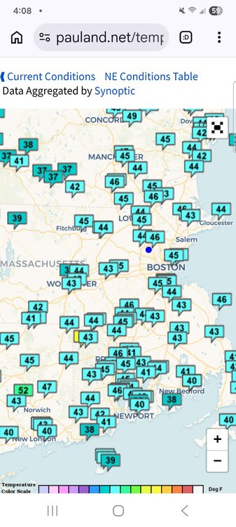
Mid-50s in Vermont: 07 15:56 N 3 10.00 Fair CLR 54 43 67% 29.8 1009.1 07 14:56 Calm 10.00 Partly Cloudy SCT046 SCT095 55.9 44.1 65% 29.84 1010.2 07 13:56 N 3 10.00 Mostly Cloudy FEW055 BKN110 54 42.1 64% 29.88 1011.7 I'm here until Monday morning.
-

E PA/NJ/DE Spring 2026 Obs/Discussion
PhiEaglesfan712 replied to PhiEaglesfan712's topic in Philadelphia Region
If that's true, then it's warmer where I am in Vermont. I'm seeing mid-50s: 07 15:56 N 3 10.00 Fair CLR 54 43 67% 29.8 1009.1 07 14:56 Calm 10.00 Partly Cloudy SCT046 SCT095 55.9 44.1 65% 29.84 1010.2 07 13:56 N 3 10.00 Mostly Cloudy FEW055 BKN110 54 42.1 64% 29.88 1011.7 -
Mid week soaker prospects looking good, drought kept in check
-
A long time ago there was a poster form NWS ... his name was Ekster He told me that the NAM has winter algorithms and that they were "not yet switched to warm season" once when we were looking at the warm early spring possibility. I wonder if that's still true. Granted we have a snow pack but ... we'll probably be mixing better tomorrow whence we'll be mad melting. I think it's fascinating if people let it ... to test how warmth performs running up over this glacier. lol
-
46 and cloudy here
-
Pretty much cleared up in the last hour here. Temp up to 58.
-
Yeah, I mean it’s still been a great winter, snow depth days way up, and shows the overall importance as a skier if getting that deep early season base and then being able to ride that out. Been skiing the glades since November… it really lengthens the ski season. Feel like we’ve been at 30-45” depth in the base area for 2+ months now too.
-
Skies finally brightening...yippee. Still mid 50s.
-
He is probably looking at the temps which will always be woefully low.
-

Central PA Spring 2026 Discussion/Obs Thread
Itstrainingtime replied to Voyager's topic in Upstate New York/Pennsylvania
Just had the first TOR warning issued. Several thunderstorm warnings also out currently. -
Sun in Calvert finally. Still cool, 56F.
-
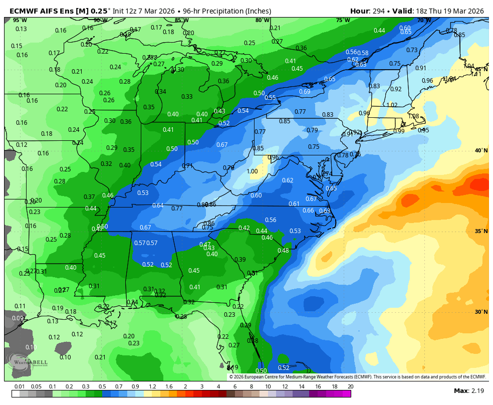
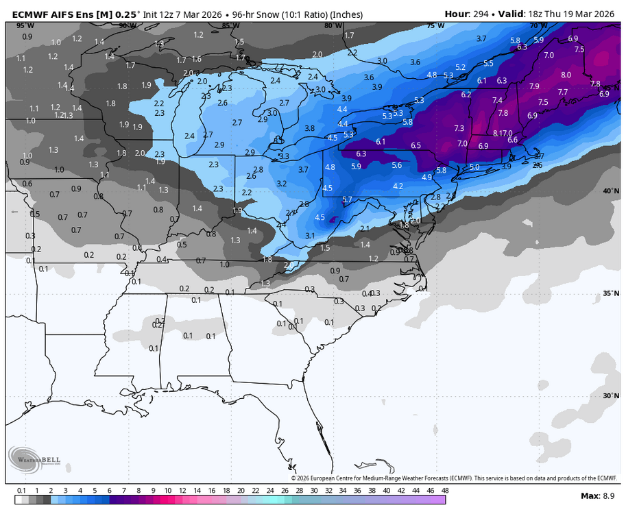
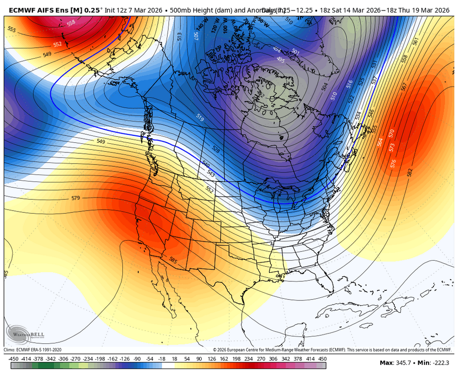
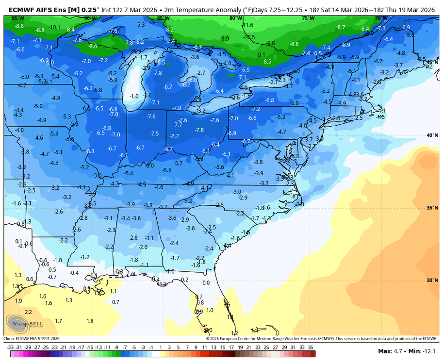
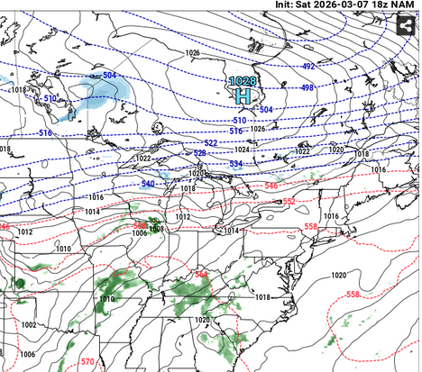
12z AI EPS for the period. The ingredients are there, we just need a specific chance or two to track in the window.

-
It is however precarious ... any time you have polar air amassing into Ontario, with > sfc pressure than what is in our area/SE ... that's teetering with correcting that boundary S. But the model run itself was not "lost of Tuesday's warmth"
-
Just hard to buy with SW flow
-

2026 Severe Wx - General Thread
HillsdaleMIWeather replied to largetornado's topic in Lakes/Ohio Valley
165 now, might be upgraded to EF4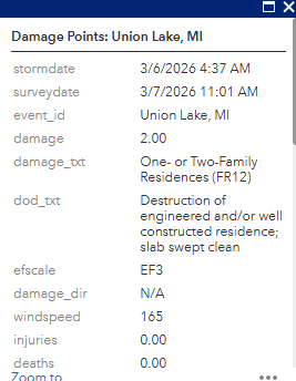
-
Glad we don't live there.
-
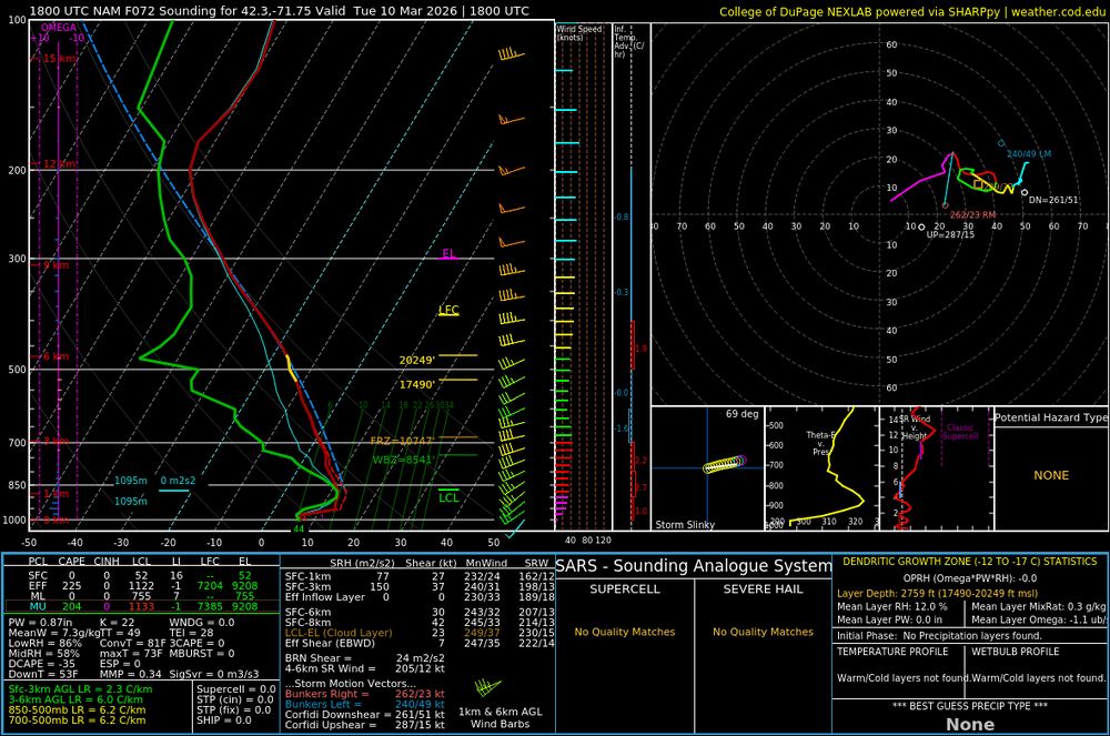
This is 21z Tues afternoon on the NAM I'm not seeing a raging argument here for a warm failure on that day ( relative to climo and previous ideas -)
-

Central PA Spring 2026 Discussion/Obs Thread
Voyager replied to Voyager's topic in Upstate New York/Pennsylvania
Still cloudy and foggy here with a temp of 44.