All Activity
- Past hour
-

Possible Light Snowfall (1" - 4") on Tuesday Dec 23
IrishRob17 replied to Northof78's topic in New York City Metro
And yet you still felt the need to point out the melting. Interesting. 29/14 and blustery. -

Possible Light Snowfall (1" - 4") on Tuesday Dec 23
coastalplainsnowman replied to Northof78's topic in New York City Metro
We definitely have the airing of grievances part covered. - Yesterday
-
I think Friday still bears some watching. A few ECM runs and GFS-AI run the precipitation into a wall of CAD. Lots of northerly low level drain. It's a much better threat for New England, but there's still enough time and enough ensemble spread... Pretty low likelihood however outside of some ice across the northern interior or maybe flakes to end.
-
RDU now has Columbia’s climate. RDUs climate has shifted to DC. Do that across the country
-
850 FXUS61 KOKX 212101 CCA AFDOKX Area Forecast Discussion...CORRECTED National Weather Service New York NY 401 PM EST Sun Dec 21 2025 ... QPF overall will be light, largely near or under a quarter inch, which will limit any potential snowfall. Forecast amounts have not changed significantly from the previous forecast, with up to an inch along the coast, and 1 to 2 inches moving inland northof interstates 80 and 95, with highest amounts in the elevated areas of the interior LoHud Valley, interior SW Connecticut, and NE NJ. Central Park Snow Observer activation is not expected at this time.
-

Possible Light Snowfall (1" - 4") on Tuesday Dec 23
psv88 replied to Northof78's topic in New York City Metro
Yea no that’s not me. Just being realistic. -

White Christmas Miracle? December 23-24th
Damage In Tolland replied to Baroclinic Zone's topic in New England
Can look at all snowmaps you want . It’s 1-5 for 99% of the fourm, 1” coast 2 interior low.. 3-4” hills .. 5 NNE.. and a very small area in ME gets 8-12. It’s not gonna change -

White Christmas Miracle? December 23-24th
TauntonBlizzard2013 replied to Baroclinic Zone's topic in New England
Very underwhelming in SNE unless someone catches a piece of the Norlun -
I live 50 miles north of NYC and I've been complaining for decades. I created this screename in the late 90's on the old Bill Evans AccuWeather weather forum and there was good reason I chose it. I had several discussions with Bill back in that time period and he said he thought the yearly average in CP was probably 4-5 inches higher than what was actually recorded. Years later 2011-2014, I discussed the problem with the NWS many times leading to the change to the conservancy taking the measurements in 2015. They always acknowledged the problem but always stated how difficult it is to get a reliable person to the park to measure. They even asked at one point if I wanted to do it, considering the distance I politely declined. Like I said earlier they then took the measurements from the Central Park zookeeper in late 2014 and started with the Conservancy taking the measurements. To repeat myself it did improve significantly from 2015-2019 but has been pretty much a shit show again since 2020. There are most likely several reasons for their constant under measurements. Where they measure, when they measure, not measuring immediately after events end so no compression and settling,and just having an organization measuring that doesn't seem to care about accuracy and timeliness. The more I write the more I think I'll be talking with them again tomorrow LOL.
-

Possible Light Snowfall (1" - 4") on Tuesday Dec 23
North and West replied to Northof78's topic in New York City Metro
good to see you before the holiday, Uncle Scrooge . -
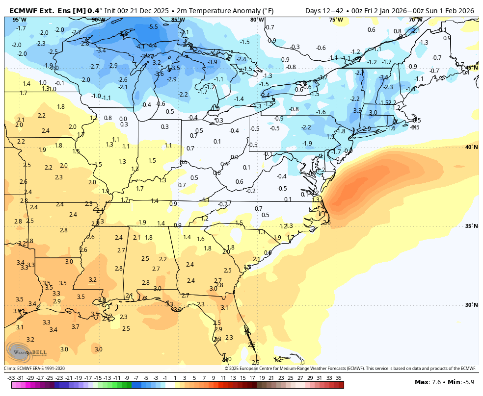
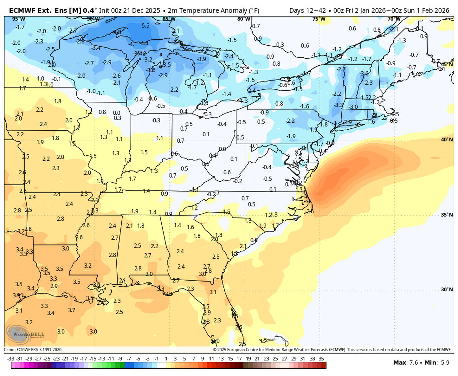
WB extended EPS 30 day anomalies for Jan.

-
I’ll take the bait, el clamino… Why is it? It looks different, right? .
-
Probably a record this Christmas as well. We've had several extremes around the south the past couple of years.
-
And since we'll sooner see omega humping an out of control NAM run than budget approval for a dedicated observer in the park, you know which way this is more likely to go.
-
DON'T get him started!
-
Pretty much all the models are focused on our area for the higher totals, Will have to see going forward if that holds, 18z Euro just came out
-

White Christmas Miracle? December 23-24th
UnitedWx replied to Baroclinic Zone's topic in New England
If that causes melts from an at most meager system, then those individuals expectations are way out of whack.... wait, I forgot where I am -
Today, I asked Eric to address his earlier thoughts about Feb having good prospects to go against the grain of warm Niña Febs should La Niña fade early. He implied that, regardless, we’re not doing enough. I then asked him, “What do you mean that we’re not doing enough? How’s ENSO looking to you for Feb?” His answer: I would like to see a big and slow MJO event to go across the entire Warm Pool in January and I am not seeing that. These Convectively Kelvin Waves are moving us towards El Nino of course, but the westerly wind bursts from them aren’t as strong or sustained as I’d like them to be to zonally advect the warm pool eastward more quickly. Our only ticket out of this crap mid to late winter is to push the warm pool east enough to extend the pacific jet to a point where we get a +PNA/+TNH/+NAO pattern instead of a -PNA/+TNH/+NAO. That seems less likely to me than say a month or so ago given how the Warm Pool has behaved to this point @40/70 Benchmark
-

Possible Light Snowfall (1" - 4") on Tuesday Dec 23
eduggs replied to Northof78's topic in New York City Metro
Warm advection precip especially with a parent low significantly separated from the overrunning can be locally unpredictable. It can be banded with distinct maxes and mins that defy typical geographical snowfall distributions. The inter- and intra-model variability supports this. As usual, this will be an interesting nowcast. With surface temperatures near or just above freezing, snow could accumulate pretty much anywhere. Can't really count anyone out for a coating to about 3". I don't think this event will reveal its character until the last moment. Hopefully when it does early Tue it appears wintry and festive. -
I don't think it has much to do with his location. He has a semi-permanent feud with east coast snow weenies and he likes to savor their tears as they torch. The problem is I have followed him off an on since 2023 and he seems to be extremely knowledgeable. He dives "under the hood" into the mechanics of the synoptic scale of the atmosphere and doesn't just rip and read from the models. In 2023-24 he was down on the canonical nino pattern appearing in late Jan/Feb, and he was correct. Last year he was up on the possibilities for SE snow and he was right about that as well. Like Bob says if he knew it all he'd be rich as an energy trader, but if he is making bold claims, I would look into his basis before dismissing him off hand.
-
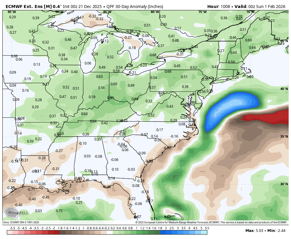
Hey, Will post the 30 day precipitation anomaly map for January 1 through February 1
-

White Christmas Miracle? December 23-24th
Great Snow 1717 replied to Baroclinic Zone's topic in New England
I agree BUT the usual suspects will melt if they miss out ..lol -

White Christmas Miracle? December 23-24th
TalcottWx replied to Baroclinic Zone's topic in New England
Unrealistic expectations from weenies. -

Possible Light Snowfall (1" - 4") on Tuesday Dec 23
Northof78 replied to Northof78's topic in New York City Metro
1" - 3" nice little storm coming with temps in 20s for almost all, enjoy it! -

Possible Light Snowfall (1" - 4") on Tuesday Dec 23
wxman replied to Northof78's topic in New York City Metro
for the restofus..........