All Activity
- Past hour
-
Nothing from MRX has been updated since 1:30 or so
-

January 25/26 Jimbo Back Surgery Storm
Brick Tamland replied to Jimbo!'s topic in Southeastern States
RAP has snow here in Wake at 6:00 PM tomorrow night, while the others don't have precip here until after midnight. -
Risky forecast giving a haircut on south shore down near PYM/Duxbury/GHG/Carver....while it's possible they get sleeted on, they could really stack it up from ocean enhancement too.
-

Jan 24-26 Weekend Snow and Sleetfest Model Thread Part Tres
Eskimo Joe replied to H2O's topic in Mid Atlantic
Mesonet stations out west showing temps really diving. Frostburg down to 20°, Bittinger down to 18°, with single digit wind chills. -
I don’t like these trends
-

Jan 24-26 Weekend Snow and Sleetfest Model Thread Part Tres
Solution Man replied to H2O's topic in Mid Atlantic

-

Possible Record Breaking Cold + Snow Sunday 1/25 - Tuesday 1/27
BoulderWX replied to TriPol's topic in New York City Metro
RRFS was definitely worse -

January 24-26: Miracle or Mirage JV/Banter Thread!
SnowenOutThere replied to SnowenOutThere's topic in Mid Atlantic
I think we’re okay for now with the NAM. It seems to be motivated by synoptic stuff imo which seems unlikely for the NAM to lead the way on. -
GFS just again plows the area lmfao
-
It went from the mantle to the garbage can, Some get shook pretty easy.
-

Possible Record Breaking Cold + Snow Sunday 1/25 - Tuesday 1/27
Wxbear25 replied to TriPol's topic in New York City Metro
Man, Long Island is on a razors edge. Close enough where its still feasible a small change in track makes a huge difference but still, models almost always underdo mid-level warmth and low-level cold. I'm sticking with a general 8-12 island wide though... counting on the thump coming in like a banshee -

Jan 24-26 Weekend Snow and Sleetfest Model Thread Part Tres
konksw replied to H2O's topic in Mid Atlantic
Maybe the GFS is just right? -
MRX not do an AFD around 4pm today? Noticed ice cumulation map changed
-
That’s ugly for the GSP metro area. Yikes.
-

Jan 24-26 Weekend Snow and Sleetfest Model Thread Part Tres
snowfan replied to H2O's topic in Mid Atlantic
This front is no joke. Frederick: 41 State College: 16 Bradford, PA: 0 -

Central PA Winter 25/26 Discussion and Obs
pasnownut replied to MAG5035's topic in Upstate New York/Pennsylvania
GFS held serve. Man do I wanna believe. NAM's hard not to consider tho. 0z's gonna be boom r bust for LSV. If Euro holds, I'll breathe a little better. -

1/24-1/25 Major Winter Storm - S. IL, IN, and OH
OHweather replied to A-L-E-K's topic in Lakes/Ohio Valley
Yeah that seems like a fair bare minimum. To their credit, they’ve realized that the FV3 core the GFS/RRFS currently run on won’t work, and the next version of the RRFS will be run on an MPAS core. Early indications are that will be much better. With that said, that they’ve decided to still move ahead with making the RRFS/REFS operational and turning off the NAM and several other models that go into the HREF while the RRFS still is running on the shitty model core that they’ve acknowledged they need to replace is certainly a choice. -

Possible Record Breaking Cold + Snow Sunday 1/25 - Tuesday 1/27
EastonSN+ replied to TriPol's topic in New York City Metro
Better: GFS RGEM Worse: NAM ICON Held: GFSAI -

Possible Record Breaking Cold + Snow Sunday 1/25 - Tuesday 1/27
Stormlover74 replied to TriPol's topic in New York City Metro
Wow
-

1/24-1/25 Major Winter Storm - S. IL, IN, and OH
Radtechwxman replied to A-L-E-K's topic in Lakes/Ohio Valley
Gfs still not budging -

Central PA Winter 25/26 Discussion and Obs
MAG5035 replied to MAG5035's topic in Upstate New York/Pennsylvania
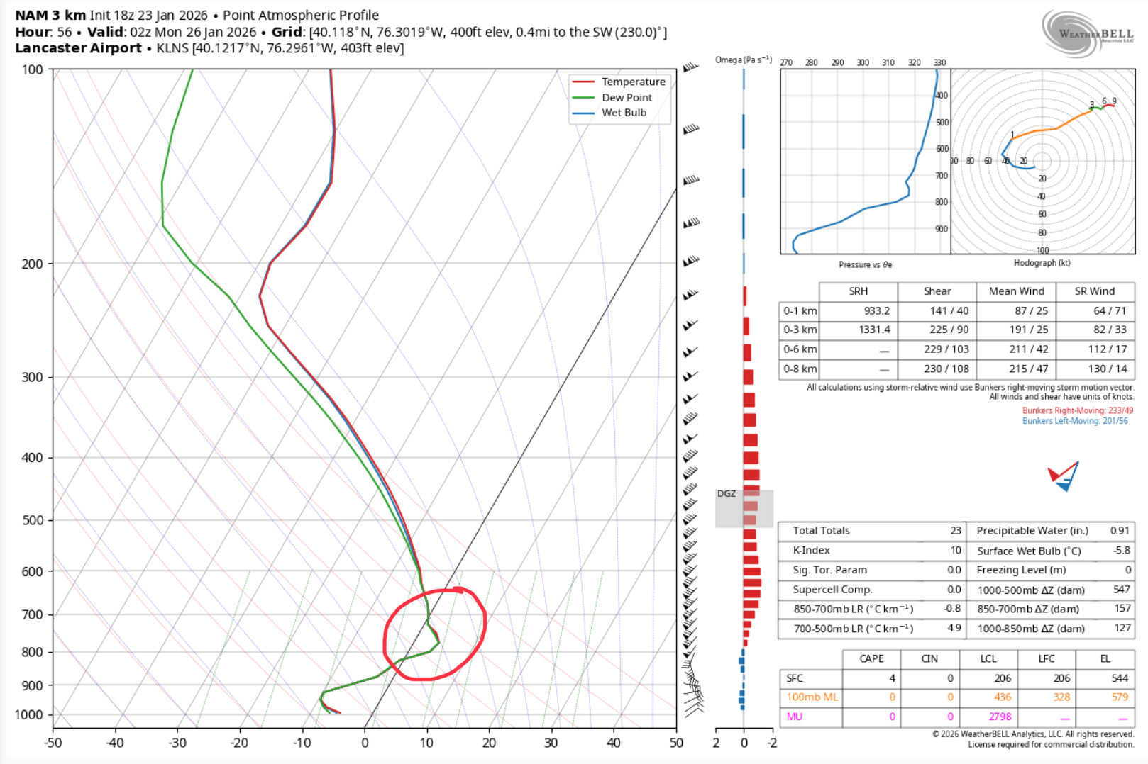
Now that this is finally into 3k NAM range we can have a look at the sounding to see what we’re dealing with in terms of warm air intrusion aloft. Sounding for LNS (Lancaster) at hour 56 As you can see, the warm air intrusion is pretty high, situated between the 850mb and 700mb layer. That’s why at first glance the 850 and 700 mb temp maps might look okay for an all snow column. Could it be too aggressive with the WAA at that level? Sure, but I’ll forewarn that this was the exact situation that sunk the significant snow in a lot of NE PA back on 12/26. NAM was about the only thing that caught that. And it doesn’t matter how cold it is at the surface. When you melt a falling a snowflake it doesn’t turn back into a snowflake when it refreezes. This is a different storm setup to be sure, and again.. there will be significant snows before any mixing where it happens. And sleet will be the predominant mix type given strength and depth of the arctic air mass.
-
Jan 24-26 Weekend Snow and Sleetfest Model Thread Part Tres
SnowenOutThere replied to H2O's topic in Mid Atlantic
Icon for some reason is way way warmer in the mid levels than everyone else. I assume it’s just a thing it does? Even in Cvill most soundings show sleet besides it. CMC and RGEM have lead the way with this storm since Monday. We all laughed at the CMC mixing back then but lo and behold it was right! -

MO/KS/AR/OK 2025-2026 Winter Discussion
stormdragonwx replied to stormdragonwx's topic in Central/Western States
TSA seems to be jumping on what the GFS is saying too. They upped the totals in the WSW text to 8-14" with local 18" totals. Blowing and drifting snow also expected. Wonder if they will issue Blizzard Warnings? My area has never had one. https://forecast.weather.gov/wwamap/wwatxtget.php?cwa=TSA&wwa=winter storm warning -

Pittsburgh/Western PA WINTER ‘25/‘26
CoraopolisWx replied to Burghblizz's topic in Upstate New York/Pennsylvania
WSWarnings from Mexico to Montpelier. Impressive -

Jan 24-26 Weekend Snow and Sleetfest Model Thread Part Tres
grhqofb5 replied to H2O's topic in Mid Atlantic
Gotta love this. What are chances that a weather model is going to be able to identify a 15 mile wide strip of land where “thundersnow” will occur 36 hours before a storm starts?