All Activity
- Past hour
-
Yeah I think this is what it is. It can officially be over 4", but be hard pressed to find an actual snow depth to match that this morning.
-
If there's a place that's prepared for this last minute, it's your neck of the woods. Congrats!
-
Carver, typically I get excited when John homenuk posts because he knows his stuff and i haven't seen him post in a while. His screen name was earthlight back at eastern weather forum and americanwx. Im just ready for some action lol.
-
Seems very reasonable, but keep expections tempered for now until we get closer in.
-
Allan talks about the transition period and how the pattern may evolve going forward. There seems to be more concensus about a mid month warm-up ahead of the improving Pac. We shall see. Allan Huffman @RaleighWx · 1h 1) As others have posted today, this look around 1/7 could be conducive to a potential East Coast winter storm. A west-based -NAO, a deep trough axis along the East Coast. We do lack a western NA ridge to really push cold air south though. If we can get a s/w to drop into the Deep South/TN Valley far enough SW it could help pop a low near the SE/mid-Atlantic coast. Certainly no guarantee but the chance is there. 2) I do think in general the period between 1/5 and 1/15 or so will see a transition to the overall long wave pattern. On today's 12z EPS, notice we see a ridge over Central Asia, a trough into east Asia and a ridge builds downstream over western North America. We could even see perhaps a Kona Low go into Hawaii which would re-enforce potential blocking ridging over the NE Pacific and provide an active subtropical jet stream. I do think this goes to a solid -EPO by mid-month. Show more Allan Huffman @RaleighWx 3) However in this transition period say day 12-17 or so, we could see milder temps for a few days across much of NA as the cross-polar flow temporarily shuts off. The west-based-NAO though may keep the Lakes/East normal or a little below normal. But our source region in Canada will warmup and will need some time to replenish the cold air via cross-polar flow. 4)Todays EC46 shows how this could play out and by weeks 3/4 we see a cold looking pattern with cross-polar flow, a -EPO/-AO/-NAO look and the cold air replenished in Canada. This would take us into late January. So I do think the 2nd half of January look promising for cold/snow in the East. We shall see!
-
https://x.com/bam_weather/status/2005038182279381143?s=20 Great BAM video here. Here are his main points: 1. Winter storm around Jan 4-8, specifically stating "it's gonna be a big one" and it'll "probably be an ohio valley, mid atlantic coastal" storm. 2. There will be a moderation period after the big storm 3. January 15-30 will be "cold and stormy"
-

Central PA Winter 25/26 Discussion and Obs
Blizzard of 93 replied to MAG5035's topic in Upstate New York/Pennsylvania
Next up for a light snow chance is another Clipper potential around New Year’s Day.
-
The NAM at one point had Long Island changing to mostly sleet and barely any snow. It failed out here with the thermals big time.
-
Happy for the south shore crew. Love to see you guys clean up.
-
Amen brother
-
That’s due to the weather records not going back far enough in time on Long Island. Other spots like Newark with records back as far as the 1840s showed that something much closer to wall to wall cold and snow was the norm. The 30 year average seasonal snowfall at Newark was 43.7” with an average winter temperature of 30.4”.
-
It happened a lot from 2010-2015. those 5 years had many storms of snow on snow. I want to say 2014-2015? Insane snow cover and repeated snow in snow. I think at one point we had snow from like 5 different snows down at once.
-
BAM Weather @bam_weather · 1h The type of set-up into the second week of January won't be one that favors major arctic cold, but can offer up increased winter storm potential for the East Coast. No signs of this strong -NAO set up breaking down any time soon. Top analogs into January based on the Polar Vortex and Tropical Forcing also support the idea of a favorable set-up for snow in the lower OH/TN Valley regions and the Mid-Atlantic. Eventually as convection once again traverses the equatorial Pacific Ocean, we should see the Alaskan ridge (-EPO) rebuild and allow for a more widespread/consistent shot of cold air across the US mid-late January. The EPS Weekly is already hinting at this idea. Stay up to date with our Energy Reports on the pattern ahead here: https://bamwx.com/register/energy-commercial/
-
From the MA forum pattern thread...Interesting about the +NAO bias. I am pretty sure that Jon Wall was/is a longtime poster on the SE forum.
-

January 2026 regional war/obs/disco thread
Ginx snewx replied to Baroclinic Zone's topic in New England
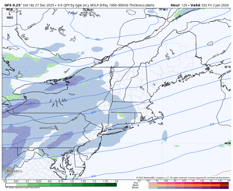
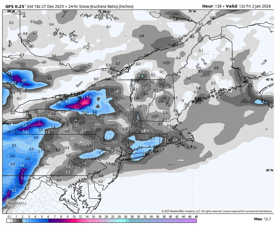
Nice 4 to 6 on 18z GFS on the 2nd -

December 2025 regional war/obs/disco thread
WxWatcher007 replied to Torch Tiger's topic in New England
Going to be my first icer here. Elevation may put me in a warm spot given the temperature aloft. -
Was that a question.................................?
-
December 2025 regional war/obs/disco thread
Ginx snewx replied to Torch Tiger's topic in New England
GFS has 4 to 6 here the 2nd -
A non hostile PAC only helps the -NAO to be more effective. Not asking for a +3 SD PNA but I wonder how well we get small snows with a PNA that hovers around neutral
-

December 2025 regional war/obs/disco thread
Typhoon Tip replied to Torch Tiger's topic in New England
4 aspects go against anything of consequence... -- system movement too fast. 6 hours and the QPF's done reporting -- not enough in situ +PP over Ontario/QUE already dammed into the region. -- related to that ... cold is not being actively supplied with sub 0C DPs undercutting; without that thermodynamic fix, latent heat of phase change will self-defeat the situation -- not enough QPF This is a road skidder and a couple submissions to funniest home videos type ordeal ...aka advisory should do it.. I do agree though that with initial cold in the Ekman BL drag working with speed of system translation, the whole thing should probably be done with and on the west side of the escaping lp before warm sector makes very far N. -
All ensembles slowly build a +PNA ridge between 240-360 hrs. AK vortex quickly fades and retros west
-

December 2025 regional war/obs/disco thread
Damage In Tolland replied to Torch Tiger's topic in New England
There’s a few shots Wed— next weekend. Might only be one .. or possibly two different light events . Fast flow -
I received 2.5" (maybe 2.8" figuring in compression), so I would naturally assume Central Park was not going to excced central Union County NJ (about 10 miles south/southwest of Newark Airport). But the storm was farther north and east, so the CPK measurement is not suspect, in my opinion...
-
Gfs has the NYD clipper - we are in business.
-
December 2025 regional war/obs/disco thread
Ginx snewx replied to Torch Tiger's topic in New England
2nd