All Activity
- Past hour
-

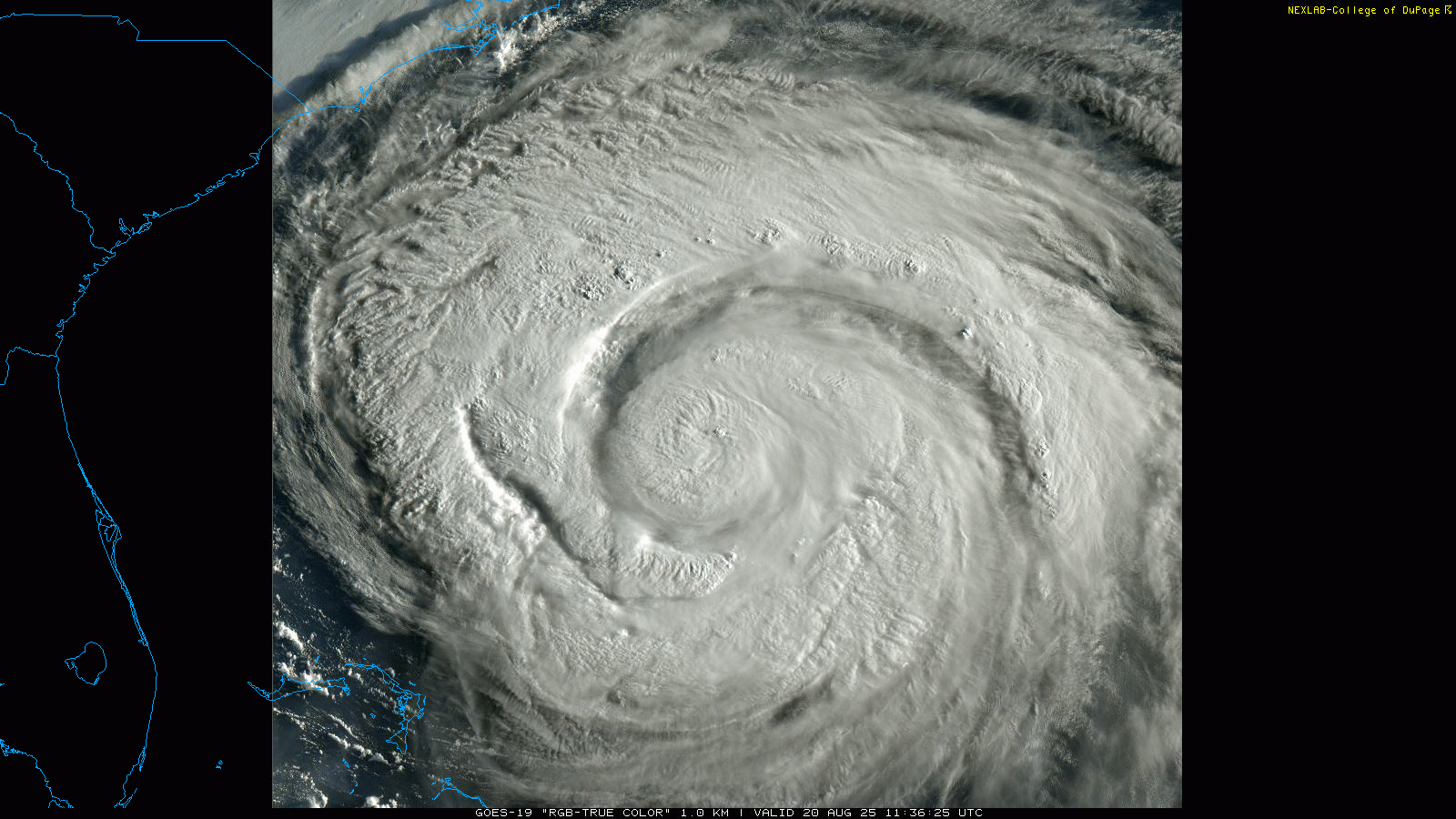
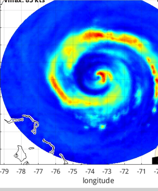
Hurricane Erin: 100 MPH - 954 mb - NNW @ 13
NorthHillsWx replied to BarryStantonGBP's topic in Tropical Headquarters
That dry air entrainment will cap any potential strengthening but with shear low and pressure falls this thing is continuing to grow in size -

Hurricane Erin: 100 MPH - 954 mb - NNW @ 13
olafminesaw replied to BarryStantonGBP's topic in Tropical Headquarters
Just uniquely stunning this morning.
-
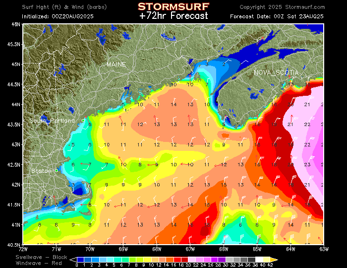
Any Maine surfers here? I know there are other surfers/snowboarders, etc., fishing and boating people. I am mostly in Rhode Island, but also have/will all over Cape Cod, North Shore Mass., South Shore, Mass. Here is the NOAA wave/wind model for a couple of days hence...simply doesn't get any better, at least over past 30 years (and no, I am not worried about "jinxing" or attracting people to certain spots...the ocean will take care of itself):
-
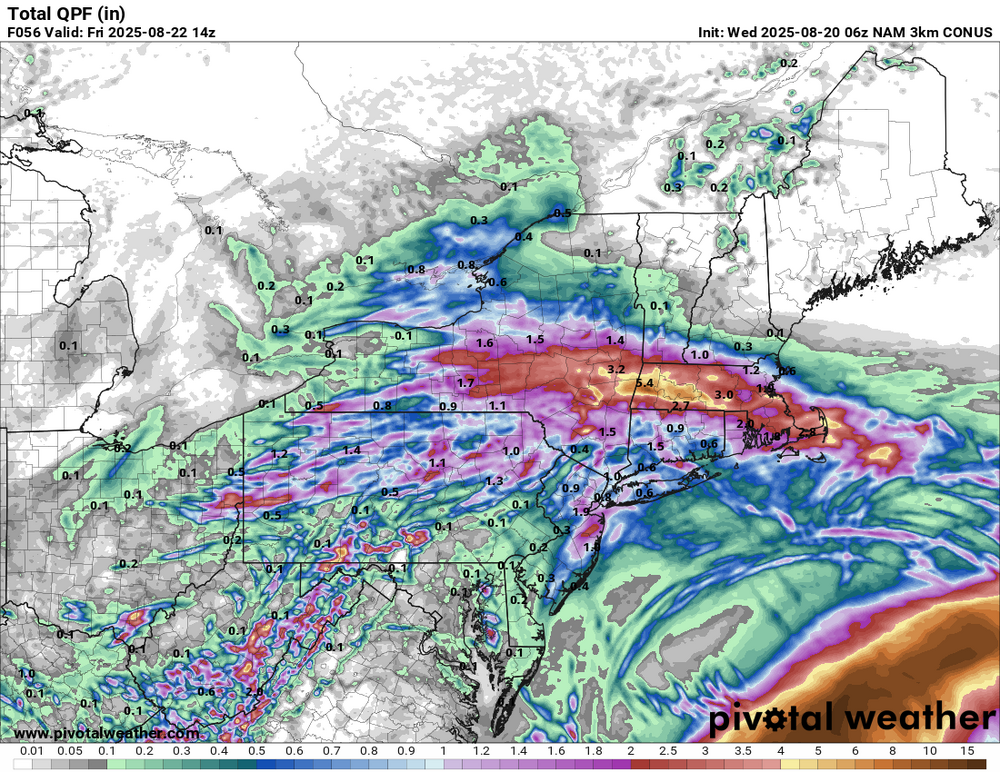
Heaviest is Sop. Maybe near pike as farther north I think. But even NoP gets decent drink.
-
Seems like most places get .50 or so and some narrow strip north of pike into SNH sees 2-3”
-
Hurricane Erin: 100 MPH - 954 mb - NNW @ 13
NorthHillsWx replied to BarryStantonGBP's topic in Tropical Headquarters
To be quite honest, other than Erin not being an annular cat 5 truck tire monster like Isabel, there are a lot of similarities. Its post-peak progression has been about the same and other than slamming headfirst into obx it’s swinging wide right by 150 miles. Current structure reminds me of Isabel a lot when it came into NC -
Hopefully today is the start of some cooler temperatures because the last week has been brutal. The Heat this past 3-5 days has been downright disrespectful!!! On a positive note, the 10-day outlook does look good with low temps in the low 60's next week and highs in the low 80's. It's almost football time in Tennessee!
-
Relax you’ll get a decent drink.
-
sometimes you take what is said here way to literally. Like, "back broken" is not a metrological term, I am pretty sure everyone here is aware of that. and I am pretty sure that 99% of the posters here understand that since it is mid-August, there are likely to be some hot days before the end of the year. now my interpretation of back broken means that MOST of the HHH days are behind us, with some cooler (no DIT, I am not forecasting 30's) days and nights. and that interpretation also means that YES, I expect some hot days too. Like you said, it is all very subjective
-
So dreary! Hope we see some sun today. Looking out the windows at the gym yesterday seeing trees with half their leaves on the ground due to the extreme drought here along with the gray sky made it look like November
-
It’s like a hybrid PRE Anyway, nice to see some rain here. Wish it was an hour later but won’t complain.
-
Same. Up to 0.60” on the month.
-
Not really a PRE
-
When you scroll over on pivotal I found a 10.52 max. Doubt it happens but would ve some epic flooding
-
3k is wild and gives someone 10
-
 Not threading but will be interesting this afternoon-tonight. from my view of multi modeling...one axis of potential excessive is near I90 to ne CT-RI, and a secondary axis from Monmouth-Ocean Counties to e LI. Whether out NYC subforum sees isolated 2-5", I'm unsure so no thread. Will post the 24 hour amounts via CoCoRaHs around 845A Thursday.
 -

Hurricane Erin: 100 MPH - 954 mb - NNW @ 13
LongBeachSurfFreak replied to BarryStantonGBP's topic in Tropical Headquarters
As beaches are being rearranged on the outter banks and in the north east. I’m in Montauk by right now and there are already major over washes and beach erosion -
With this PRE expect 4 to 5 inch stripe somewhere in SNE
-
hearing reports of kings being caught already, probably gonna hit the harbors this weekend
-
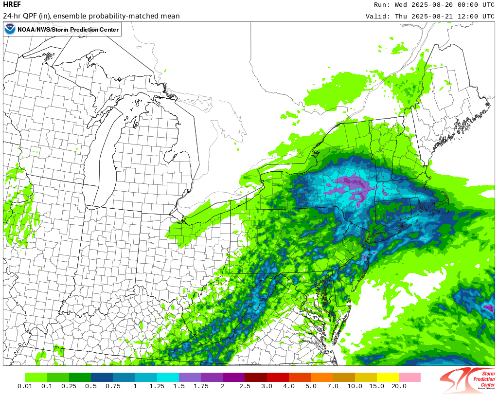
 The 8/20 0z HREF:
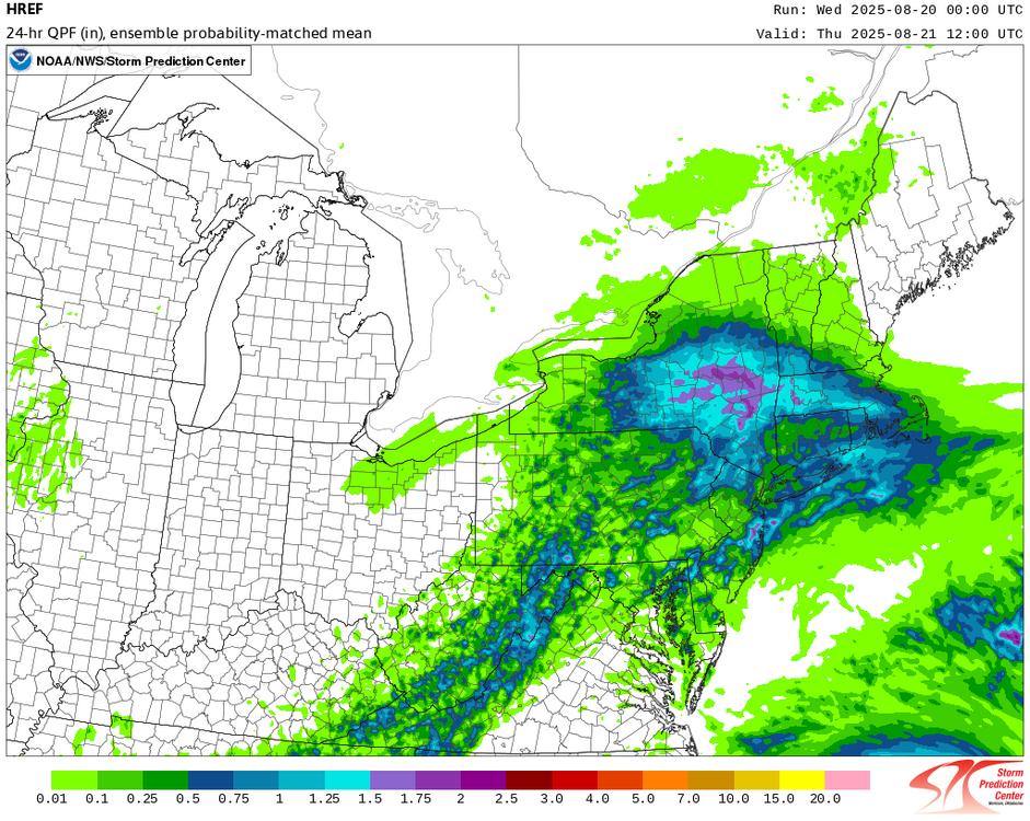
-
Judging by current radar I would agree but this is “allegedly” supposed to drop to the south, we will see. Seeing .50-1.00” around here, will see if that materializes.
- Today
-
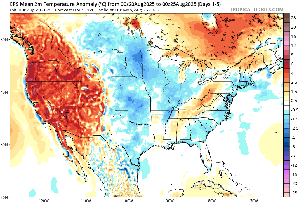
 We generally need a least a recurving hurricane from August 20th through 31st to avoid 90° heat at the warm spots like Newark. This could be the first August since 2011 and 2008 that Newark remains below 90° during this period. We had Irene in late August 2011 and Hanna in 2008. But those systems came further west than Erin will. So this shows that even a storm recurving to our east can cool the pattern when interacting with a trough in Eastern Canada. Time Series Summary for NEWARK LIBERTY INTL AP, NJ August 20th to 31st Max Temp Click column heading to sort ascending, click again to sort descending. 2024-08-31 95 0 2023-08-31 91 0 2022-08-31 93 0 2021-08-31 97 0 2020-08-31 93 0 2019-08-31 92 0 2018-08-31 96 0 2017-08-31 91 0 2016-08-31 95 0 2015-08-31 94 0 2014-08-31 93 0 2013-08-31 91 0 2012-08-31 94 0 2011-08-31 89 0 2010-08-31 98 0 2009-08-31 94 0 2008-08-31 86 0
-
Hazardous Weather Outlook National Weather Service State College PA 355 AM EDT Wed Aug 20 2025 PAZ006-011-012-017>019-024>028-033>037-041-042-045-046-049>053- 056>059-063>066-210800- Potter-Cameron-Northern Clinton-Clearfield-Northern Centre- Southern Centre-Cambria-Blair-Huntingdon-Mifflin-Juniata-Somerset- Bedford-Fulton-Franklin-Tioga-Northern Lycoming-Sullivan- Southern Clinton-Southern Lycoming-Union-Snyder-Montour- Northumberland-Columbia-Perry-Dauphin-Schuylkill-Lebanon-Cumberland- Adams-York-Lancaster- 355 AM EDT Wed Aug 20 2025 This Hazardous Weather Outlook is for central Pennsylvania. .DAY ONE...Today and tonight. Scattered, slow-moving and potentially training thunderstorms could produce locally heavy rainfall over one inch in less than an hour. A few instances of flooding in poor drainage areas, and along small streams and adjacent roads is possible later this afternoon and evening. .DAYS TWO THROUGH SEVEN...Thursday through Tuesday. The probability for widespread hazardous weather is low. .SPOTTER INFORMATION STATEMENT... Spotters are encouraged to report significant hazardous weather, including heavy rainfall over one inch and any flooding. $$
-
-
Enjoying my 0.01”