All Activity
- Past hour
-
 95 here Stay cool
 -
My guess is NYC will fail to reach 100 both days but may get a 99
-
Jul 22 , 2001 Upper air maps
-
Yea the RRFS may be a formula for better future CAMs. I still like the HRRR because it shows what would happen if we overmix by some chance, almost like a goalpost kind of scenario.
-
Thanks, Don. I’ll reiterate that I was referring to only E US rather than all of the U.S. mean temps (especially in July) and that I didn’t even consider 2023 because it was only borderline moderate/strong on a RONI basis with a peak of only +1.49. So, 2015, with its heatwave in the Pacific NW (nowhere close to the E US) and 2023 not being nearly strong enough to count as super-Nino per the now official (per NOAA) RONI basis don’t even count for me against super El Niño E US heat. And even if 2023 were counted, its heat was most concentrated in the SW/SC rather than E US.
-
July 2 1989: Softball sized hail falls near Dorset, and baseball sized hail is reported at Nevis in Hubbard County. 1972: A low of 32 is recorded at Big Falls in Koochiching County. For Thursday, July 2, 2026 1833 - An unusually large New England tornado, one half to three quarters of a mile wide, went from Salem Pond to Norton Pond, VT, and then into Canada. It prostrated nearly everything in its path. (The Weather Channel) 1843 - An alligator reportedly fell from the sky onto Anson Street in Charleston, SC, during a thunderstorm. (David Ludlum) 1987 - Thunderstorms in Colorado produced hail as large as golf balls northwest of Kiowa, which accumulated to a depth of twelve inches. Hail two and a half inches in diameter was reported at Black Forest. Hail damaged 900 acres of crops south of the town of Wiggins. (The National Weather Summary) (Storm Data) 1988 - Twenty-six cities in the eastern U.S. reported record low temperatures for the date. The morning low of 47 degrees at Roanoke, VA, broke the July record set the previous day. (The National Weather Summary) 1989 - Thunderstorms produced severe weather in the south central U.S., with 158 reports of large hail and damaging winds through the day. Evening thunderstorms in northeastern Texas produced softball size hail which caused more than five million dollars damage at Allen, and wind gusts to 90 mph at Dallas, which injured eight persons and caused seven million dollars damage. Winnfield LA reported 29.52 inches of rain in six days, for a total of 62.50 inches for the first six months of the year. Midland, TX, reported an all-time record high of 112 degrees. (Storm Data) (The National Weather Summary) Observances: 2 Thu National Wildland Firefighter Day 2 Thu I Forgot Day 2 Thu Civil Rights Act 2 Thu Made In The USA Day 2 Thu National Anisette Day 2 Thu National Disco Day 2 Thu National Lint Awareness Day 2 Thu National Report Military Fraud Day 2 Thu Special Recreation for the Disabled Day 2 Thu World Sports Journalists Day 2 Thu Freedom From Fear of Speaking Day 2 Thu World UFO Day
-

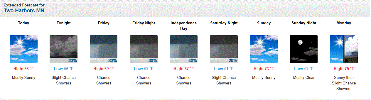
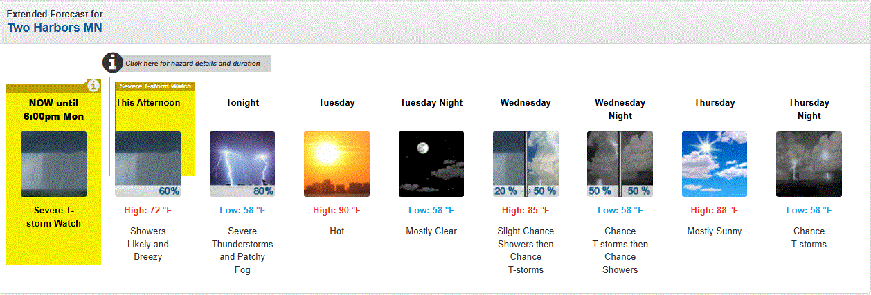
Fireworks Heat Contest W 7/1 - S 7/4 for Five MA Airports
nw baltimore wx replied to nw baltimore wx's topic in Mid Atlantic
Thanks, but it’s early. I think @MN Transplant has the definite advantage going forward, but the rest of us scrubs can still battle for individual airport titles. -
Pretty significant improvement in the east, D2 Dropped from 90 to 80% mostly because of coastal improvements
-
Day 1 has slight risk for all of middle tn and surrounding states north Alabama and Georgia north east Mississippi followed by a marginal risk for parts of west central mississippi central Alabama and Georgia the Carolinas somewhat majority of Kentucky parts of Virgina southern Illinois and Indiana Missouri and Arkansas for 5% 15% 30% non hatched for damaging wind and also 5% non hatched hail .
-
Jeez its already 95 here in Brooklyn. Air conditioners going full blast inside my house.

-
They could really use a strong monsoon flow through the 4 corners area this year. Impressive local wx tho.
-
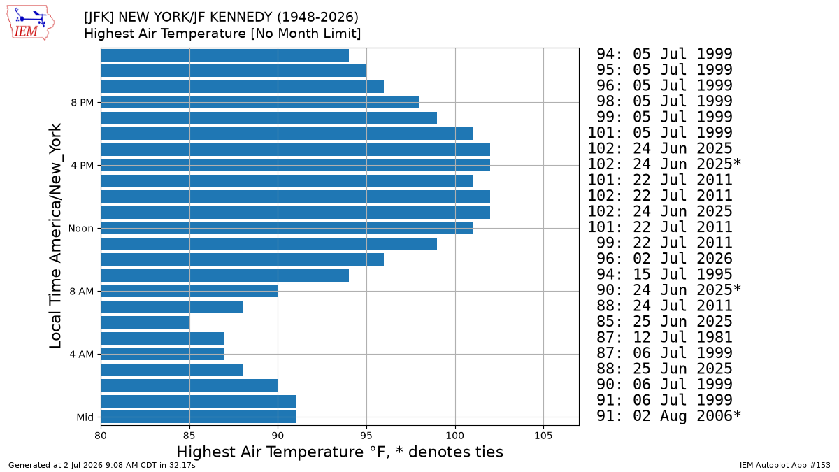
They just set the new all-time warmest 10am temperature at the station before the sea breeze arrives. https://mesonet.agron.iastate.edu/plotting/auto/?_wait=no&q=153&network=NY_ASOS&zstation=JFK&month=all&sday=0702&eday=1231&var=max_tmpf&_r=t&dpi=100&_fmt=png

-
(002).thumb.png.6e3d9d46bca5fe41aab7a74871dd8af8.png)
Central PA Summer 2026 Discussion/Obs Thread
ChescoWx replied to Voyager's topic in Upstate New York/Pennsylvania
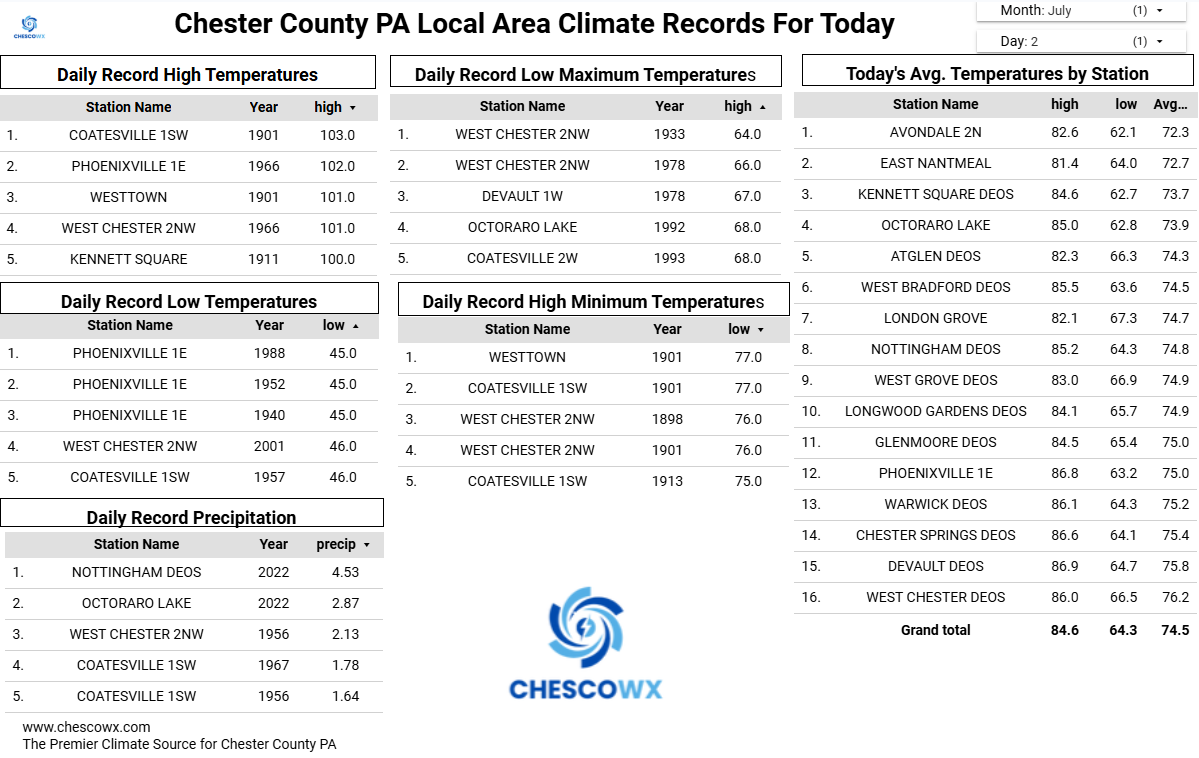
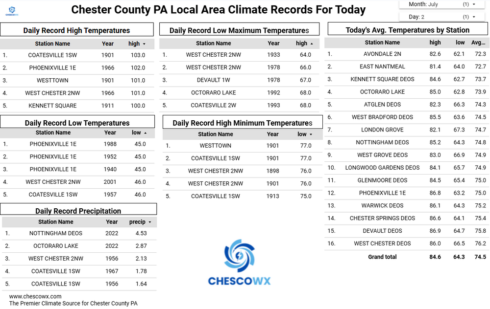
Today will be our hottest day with the possibility that many lower spots touch 100 degrees and could approach the record for the day of 103 degrees set way back in 1901 at Coatesville 1SW at 103 degrees. We have not set a record high in the month of July since back on July 24, 2016 when a record of 100 degrees was set at Phoenixville 1E. The heat continues through the weekend but with shower chances steadily increasing by later July 4th through the day on Monday. Temperatures will fall back to near normal by Tuesday and back to below normal temperatures by Wednesday.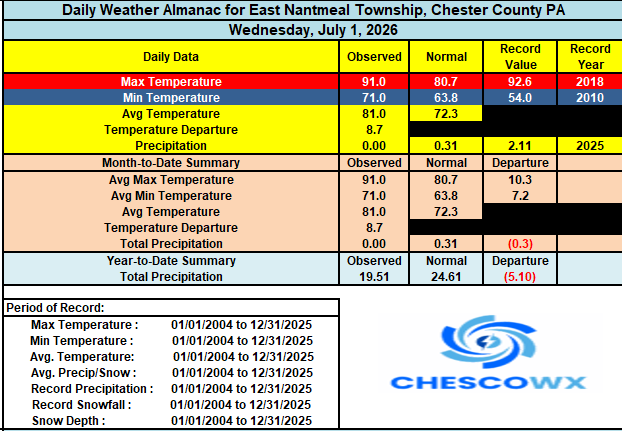
-

E PA/NJ/DE Summer 2026 Obs/Discussion
BBasile replied to PhiEaglesfan712's topic in Philadelphia Region
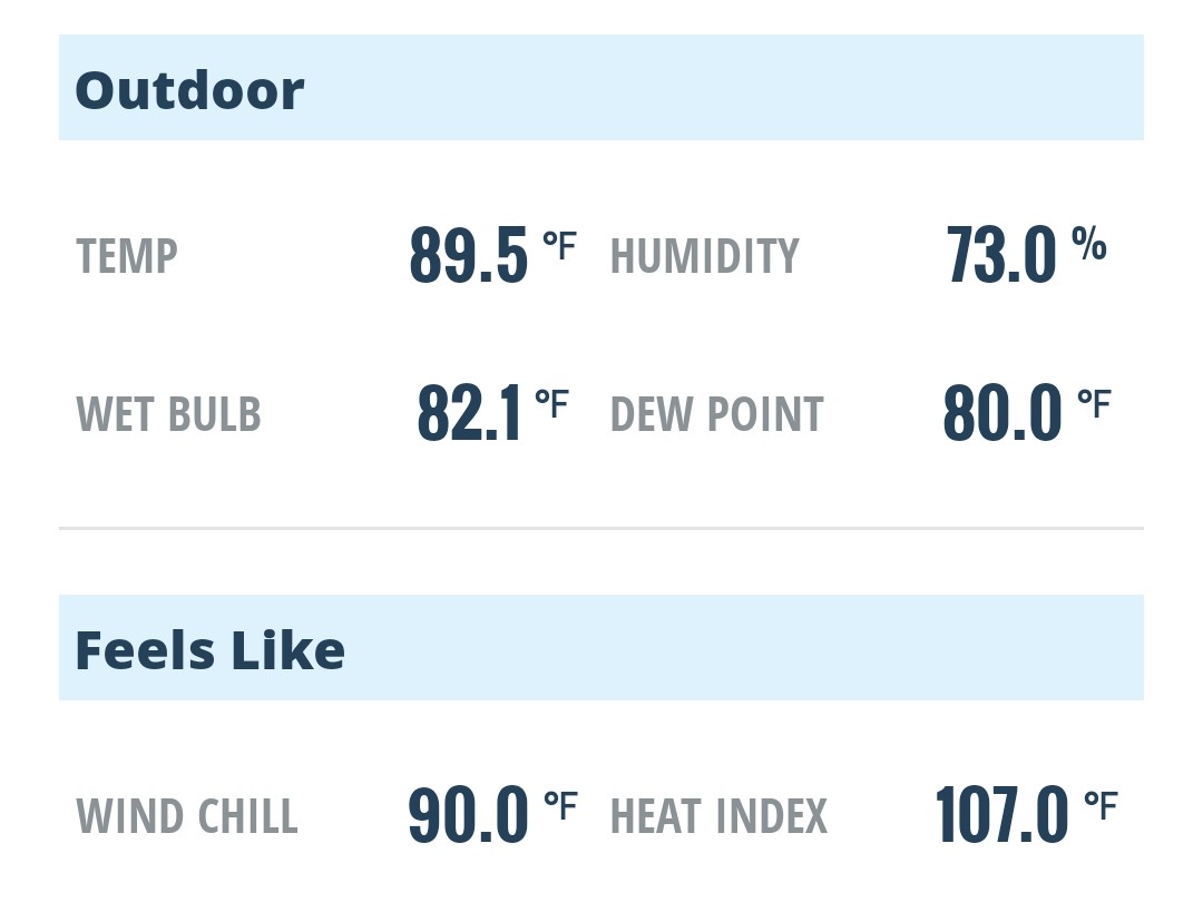
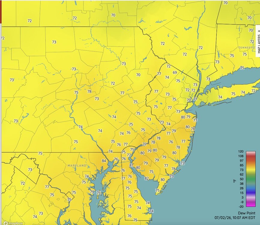
Already disgusting. That dew point!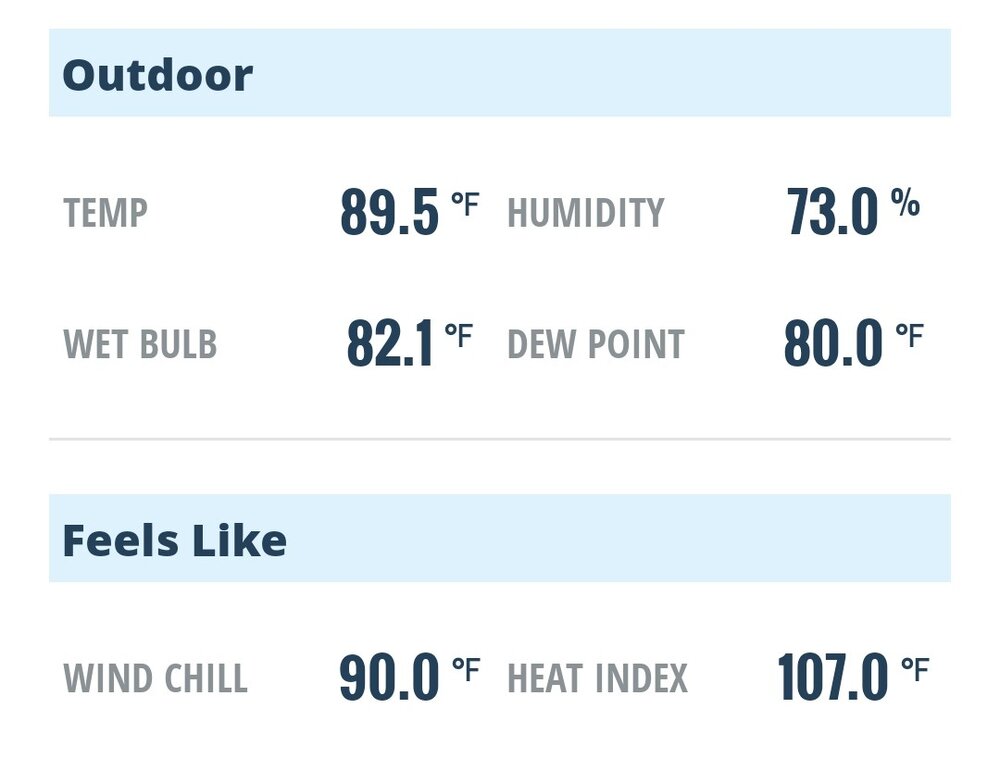
-
E PA/NJ/DE Summer 2026 Obs/Discussion
ChescoWx replied to PhiEaglesfan712's topic in Philadelphia Region
Today will be our hottest day with the possibility that many lower spots touch 100 degrees and could approach the record for the day of 103 degrees set way back in 1901 at Coatesville 1SW at 103 degrees. We have not set a record high in the month of July since back on July 24, 2016 when a record of 100 degrees was set at Phoenixville 1E. The heat continues through the weekend but with shower chances steadily increasing by later July 4th through the day on Monday. Temperatures will fall back to near normal by Tuesday and back to below normal temperatures by Wednesday.
-
One good thing that I'm seeing is that the new RRFS seems to be handling this a lot better than the HRRR. The HRRR is out of control with mixing out the boundary layer, with places like Fredericksburg with something like 108/55 tomorrow. Conversely, the RRFS is a reasonable 102/69 for tomorrow.
-
Unfortunately, that sensor is too close to the building. It's probably just 15-20 feet from the building. In general, its distance should be 4X the building's height.
-
 Tomorrow night could be really fun, could even be more fun if that EML wasn't shunting to our southwest
 -
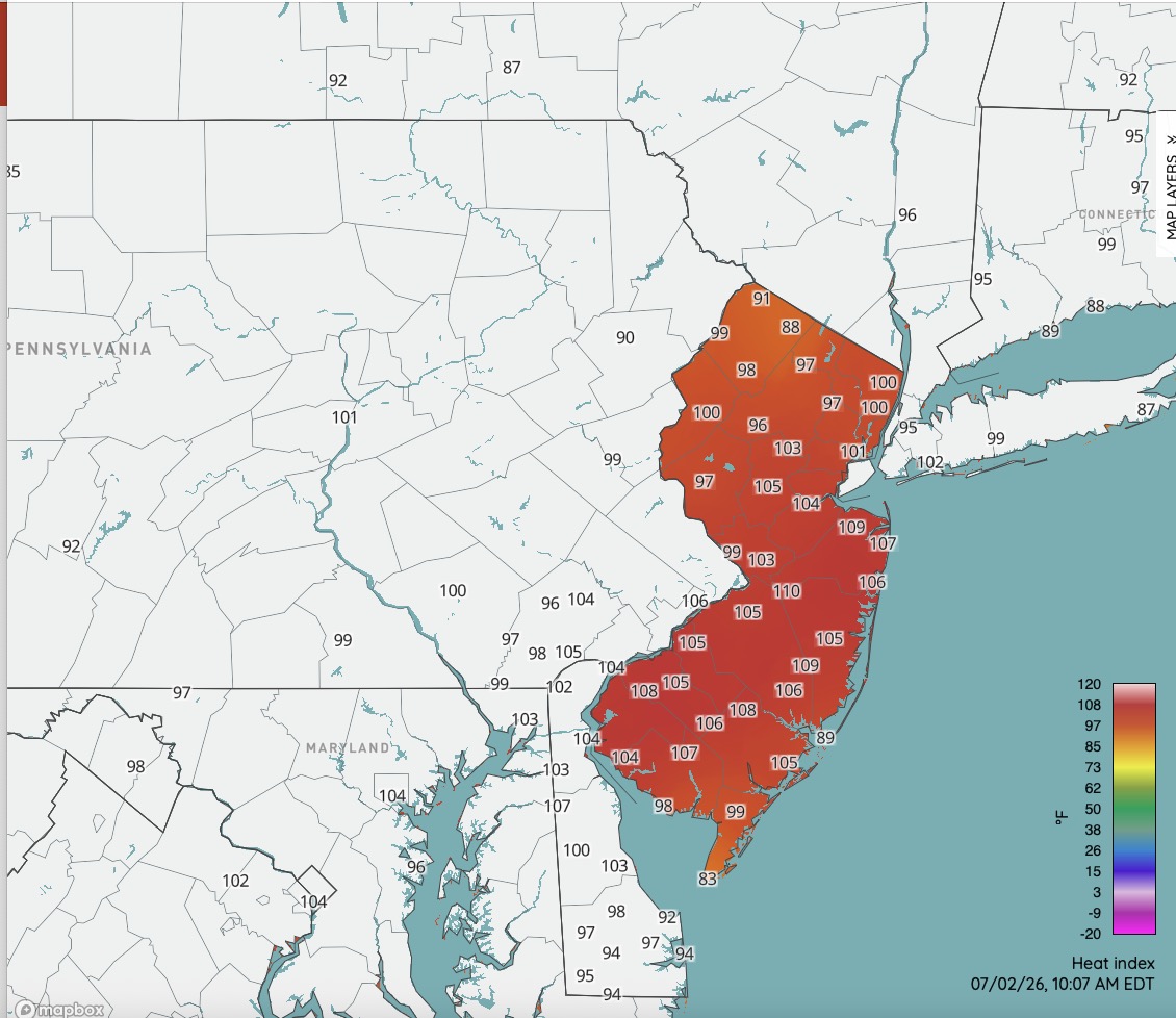
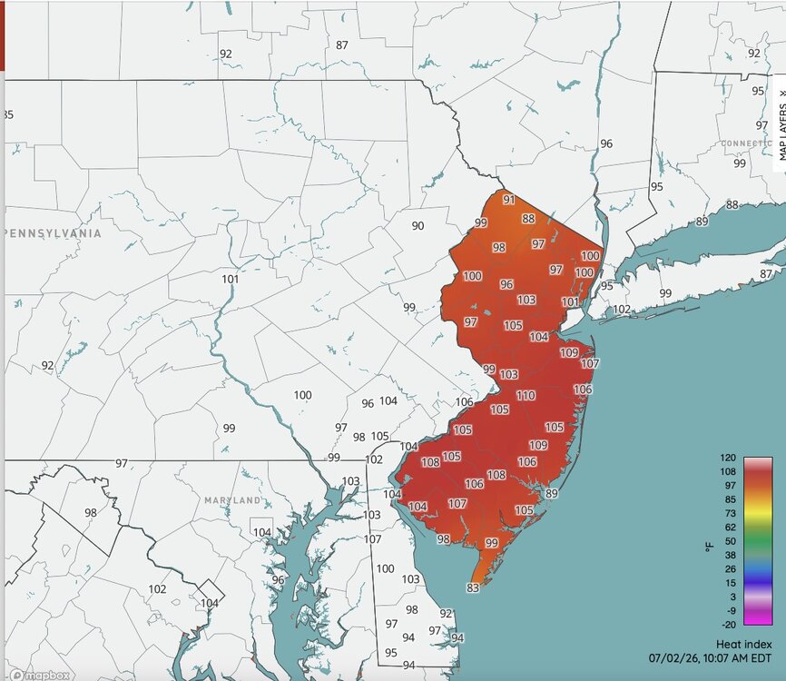
Nasty hot already. DP's will mix out some later but with temperatures 100-105 for most away from the immediate NJ shore the heat index readings this afternoon could reach 115+ across much of NJ. Approaching rare territory at those ranges.
-
One more warmer day then back to reality along the shore.
-
There shall be no struggle to reach 100 today I suspect. BWI is already at 93. I wouldn’t be surprised to see 103-104 in some areas. Stations over here east of 15 in S PA/N MD are torching.
-
 90 at Shirley right next door, but 88/73 here at 10am. Some 90 .. 91 sprinkled in a sea of 87 to 89s Solid recovery out of the overnight outflow wash
 -
FAIL! Overcooked highs.
-

Central PA Summer 2026 Discussion/Obs Thread
canderson replied to Voyager's topic in Upstate New York/Pennsylvania
Sunday we have a chance of rain. But like it has for 5 months the close we get the more south that’ll sink. -
 10am 85.3/76 at WXW1 91/70 at HFD 78/67 at SLK 75.0/70 at WXW2