All Activity
- Past hour
-
Yes. As of now looks like snow for Friday with high of 25 forecasted out my way.
-

White Christmas Miracle? December 23-24th
Sey-Mour Snow replied to Baroclinic Zone's topic in New England
GFS still way more than EURO for CT. CT is like coating to 1 on EURO, 2-5" on GFS -

White Christmas Miracle? December 23-24th
MaineJayhawk replied to Baroclinic Zone's topic in New England
Pemaquid Pummeler -

E PA/NJ/DE Winter 2025-26 Obs/Discussion
LVblizzard replied to LVblizzard's topic in Philadelphia Region
GFS is really the only model showing a lot of snow for this area…most other guidance has a big mid-level warm nose and lots of IP/ZR. Trend has been our friend over the last day though, so we’ll see if that continues. -

December 2025 regional war/obs/disco thread
WxWatcher007 replied to Torch Tiger's topic in New England
We still need to close. -

White Christmas Miracle? December 23-24th
moneypitmike replied to Baroclinic Zone's topic in New England
Yes please. -
C’mon, we just cancelled winter. .
-

White Christmas Miracle? December 23-24th
ORH_wxman replied to Baroclinic Zone's topic in New England
Well Euro was far less than GFS in central and western areas. It was only a little less in eastern areas this run. I hope the GFS is correct since it’s a widespread 3-5” deal but I’m still fairly skeptical. I think 1-3” would still be my forecast right now. -
It was nice last year where everything just kept trending colder until verification
-

Central PA Winter 25/26 Discussion and Obs
Ruin replied to MAG5035's topic in Upstate New York/Pennsylvania
lol and now they will act like it never was forecasted to be that warm. -

E PA/NJ/DE Winter 2025-26 Obs/Discussion
Kevin Reilly replied to LVblizzard's topic in Philadelphia Region
Hmm how about that 12z gfs -
Ukie and cmc we don't want going any more north.
-

White Christmas Miracle? December 23-24th
WinterWolf replied to Baroclinic Zone's topic in New England
GFS may not be out to lunch after all… -
shit id take 2 inches Just hope it lays enough to be called a white christmas. i remember years back we had snow it accumulated a good amount but then local weather did the song and dance we ddint get enough snow to be called a white christmas even tho everything was covered.
-
One you will be able to tell the grandkids about then tell them its a fairy tale from the GGEM.
-
December 2025 regional war/obs/disco thread
WinterWolf replied to Torch Tiger's topic in New England
As we like to say…you never know . -

December 2025 Short/Medium Range Forecast Thread
tnweathernut replied to John1122's topic in Tennessee Valley
Even when I'm negative on here, I'm still optimistic at heart. It's common for a snow lover to be that way. When it comes to snow in the south you'd be silly to cancel winter in December. We usually only hope for a widespread threat or two all year and it seems flukey snows happen as much as well modeled ones. Might as well hold out hope through early spring. I think one of my only contributions lately has been noting the stubbornness of the ridge in the Aleutians not being good for business (snow and cold). I was surprised to see @Carvers Gapmention 1996 had that feature. -
White Christmas Miracle? December 23-24th
ORH_wxman replied to Baroclinic Zone's topic in New England
Euro looks like it juiced up a little for eastern areas tomorrow. It also tries to clip E MA coast with the IVT Christmas Eve. -
December 2025 regional war/obs/disco thread
WinterWolf replied to Torch Tiger's topic in New England
I don’t agree. But that’s fine. I got 13” in Feb of 24…lots of other spots got 1-2”. Sometimes we win. Sometimes other places win. He’s had his share of bone jobs there too. Everybody takes their turn in the shit barrel. -
Euro AI was another nudge SW, nothing too dramatic though.
-

E PA/NJ/DE Winter 2025-26 Obs/Discussion
jwilson replied to LVblizzard's topic in Philadelphia Region
13 UTC NBM still favors odds of rain-to-snow 55:20 at maximum rain potentiality, but it closed the gap a decent amount from a peak of 66:4 at 7 UTC. In other words, there was a clear cold trend. It also now favors snow early on the day Friday, 34:28, as opposed to the 66:13 rain-favored odds from the run before. A mix is a good call right now unless the trend continues. -

December 2025 regional war/obs/disco thread
Damage In Tolland replied to Torch Tiger's topic in New England
Man what a fantastic last couple of days of trends . Expecting the unexpected worked -

Mid to long range discussion- 2025
WinstonSalemArlington replied to wncsnow's topic in Southeastern States
So true. I can’t recall models bouncing around so much for a prolonged period as they have this year -

2025-2026 ENSO
donsutherland1 replied to 40/70 Benchmark's topic in Weather Forecasting and Discussion
Is is possible that these charts also have an algorithmic issue? Here's the GEFS from NCEP's site: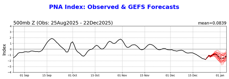
-

Mid to long range discussion- 2025
Leesville Wx Hawk replied to wncsnow's topic in Southeastern States
Hard to dig the trough far enough westward in this set up. GFS ensembles did cave to EPS but it’s still not enough for our region. Need Nina to get beat down soon to have a shot. It has been taking it’s time warming up. .


