All Activity
- Past hour
-
 Bark at the moon playing on morning run
 -

November 2025 general discussions and probable topic derailings ...
Ginx snewx replied to Typhoon Tip's topic in New England
Full moon goon! 31⁰
-

November 2025 general discussions and probable topic derailings ...
jsw replied to Typhoon Tip's topic in New England
Now 25/25, KEEN, just down the road. High Wind Watch scaled back here, but up to 47mph tonight will be nice and breezy! -
 I was just looking at the survey responses and mused about how James would have responded. RIP
 -

Overnight Wednesday, November 5, 2025 Wind Event
NoCORH4L replied to weatherwiz's topic in New England
Poop. The news was hammering it last night. Got me excited. -

Overnight Wednesday, November 5, 2025 Wind Event
ineedsnow replied to weatherwiz's topic in New England
She gone -

November 2025 general discussions and probable topic derailings ...
kdxken replied to Typhoon Tip's topic in New England
Torch! - Today
-
This ruined my whole evening....Thanks
-

Overnight Wednesday, November 5, 2025 Wind Event
Torch Tiger replied to weatherwiz's topic in New England
Looks basically the same, minor cut back -

Overnight Wednesday, November 5, 2025 Wind Event
CoastalWx replied to weatherwiz's topic in New England
yep we cancel -

Fall 2025 Medium/Long Range Discussion
sbnwx85 replied to Chicago Storm's topic in Lakes/Ohio Valley
Honored to present the first clown map of the season. We are so back.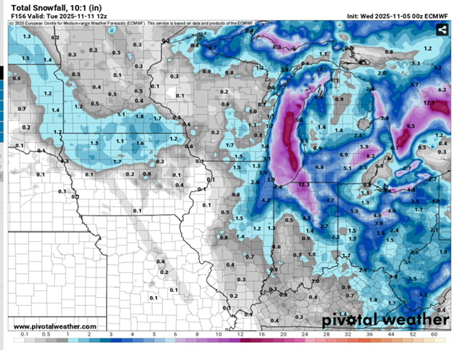
-
Overnight Wednesday, November 5, 2025 Wind Event
CoastalWx replied to weatherwiz's topic in New England
thanks wiz and vortex95. -
November 2025 general discussions and probable topic derailings ...
CoastalWx replied to Typhoon Tip's topic in New England
That’s about what a typical “in my backyard” SNE person sees every 30 years. So STFU. -

Overnight Wednesday, November 5, 2025 Wind Event
metagraphica replied to weatherwiz's topic in New England
Perfect, nobody wants damage and/or power outages. -
Yes. It's so difficult to find any info regarding events in this area. I dig through this forum a lot to find storms. Too bad it wasn't around before the 2010s.
-
BWI: 19.2" DCA: 18.3" IAD: 19.8" RIC: 11.2" SBY (Tiebreaker): 8.2"
-
Rib injuries are so dumb that I want November snow. I'm all in on a '25/26 HECS/MECS/SECS trifecta.
-
Finished with .72”
-
First Sunken Meadow, now North Shore Tower. Deer must like the golf courses because they've seen the aim of the people at those places and know they're perfectly safe.
-
Monday's rain went poof.
-
Lots of backing down by 00z model runs...
-
This is a longwave pattern that could produce some decent snow in the mountains and possibly first flakes for places east of there around Veteran's day.
-
Regardless of if Sunday Night's event is a snower or cuts west, the cold and moist cyclonic flow looks consistant and filled with potential subtle shortwave features next week. Still a ways to go until confidence increases substantially, but if the pieces align correctly a real solid upslope signature may emerge under the incoming trough.
-
Maybe some flurries make it over the mountain Monday night