All Activity
- Past hour
-
Anyone have the 18z Euro/Euro AI?
-
Silly Ken, thinking he could sneak that past .
-

February 2026 Medium/ Long Range Discussion: Buckle Up!
Scraff replied to Weather Will's topic in Mid Atlantic
What I’m really hoping for moving forward is a good 6-10” of snow with 2” of sleet on top. That could fun! -

Central PA Winter 25/26 Discussion and Obs
Blizzard of 93 replied to MAG5035's topic in Upstate New York/Pennsylvania
12z EPS & AI EPS also have the Winter storm signal for Valentine’s weekend.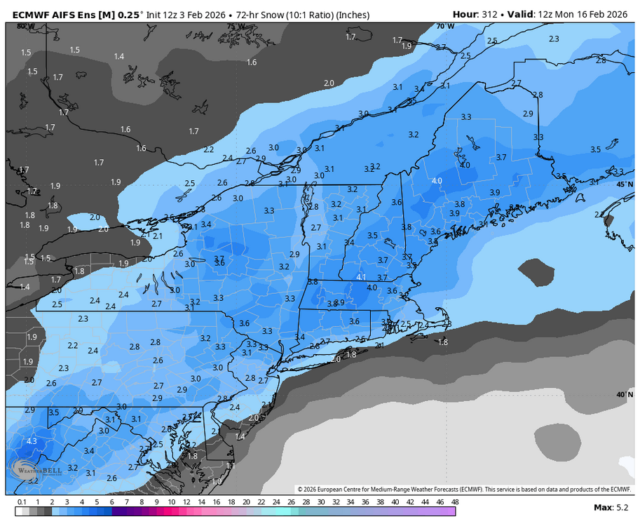
-
Hoping whatever hits/or not near next weekend, comes on the 13th or more the 15th…we have plans to get out of here for N. Maine on Saturday morning the 14th.
-
Central PA Winter 25/26 Discussion and Obs
Blizzard of 93 replied to MAG5035's topic in Upstate New York/Pennsylvania
18z GFS had an interesting solution for a Valentine’s weekend Winter storm chance.
-
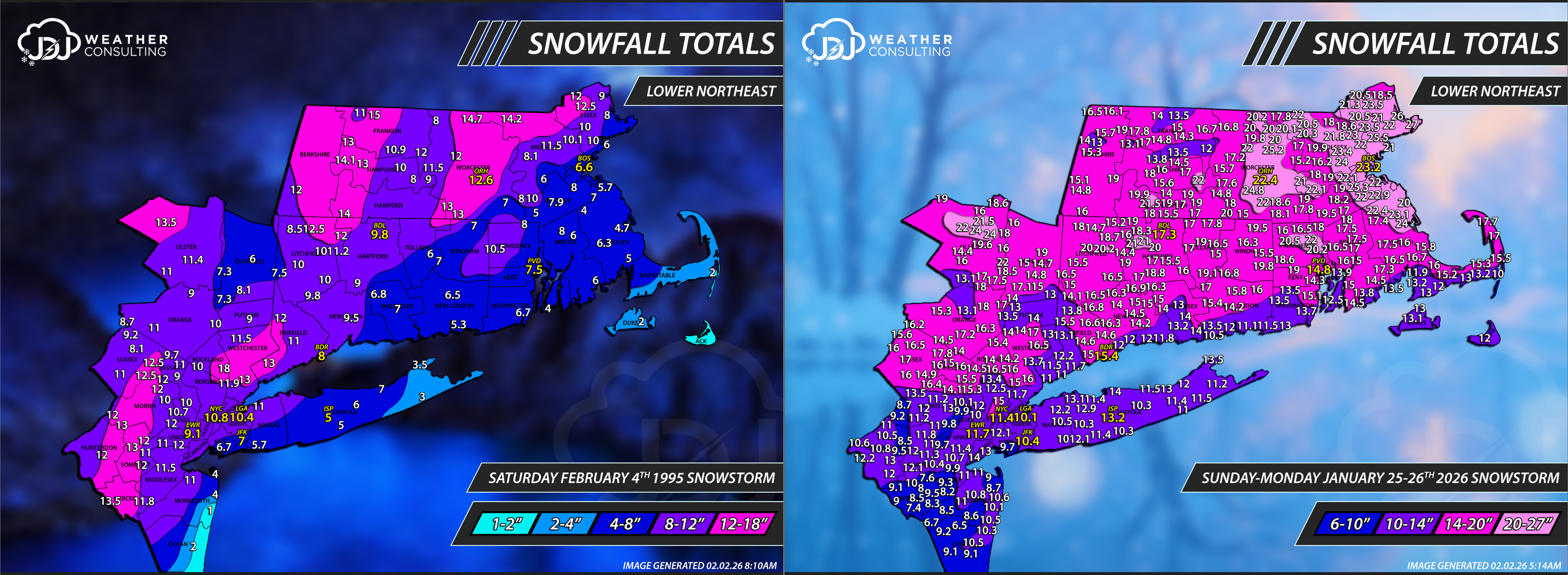
Reports were tough to come by back then, all we had was essentially COOP and climate sites. NWS just had started doing public information statements during the 96-97 winter. BOX did not do them 95-96. I just wanted to showcase the insane difference of reports now vs 30 years ago when we were essentially pre-internet era (i know dial up existed). It makes doing these analysis maps so much more difficult and time consuming but way more accurate and i am grateful for the huge network of spotters and various programs we have in the 2020s.

-
-
 It’s all coming together.
 -
The Euro is always too high with gusts, but it is putting out mid-50mph on Saturday. Shave 10 off of that and it is still a nasty day.
-
What’s your definition of “winter is over”? I’m going to enjoy the next 7 days of no torch with ups and downs, low dewpoints, and the progged highest temp of only ~69. The period should avg a bit BN and this should mean great walking wx. Afterward, I’m hoping any possible torch (say upper 70s to low 80s) is fairly tame and shortlived. Hopefully there’d still be lots of lows down in the 40s. Looking further ahead: although the Euro Weeklies maintain a -PNA and don’t have a -NAO/-AO, they cool it off to NN last week of Feb. Winter’s always my favorite season even if not cold, mainly because I enjoy the lack of bugs and humidity as well as the big swings that other seasons typically don’t have.
-
Ken, are you that silly? Yes, we all know that we had a January thaw(happens almost every year). Thanks for showing us. Before that for a month plus, and after that it’s been frigid pal. What don’t you understand about this? January finished well below normal….so that thaw got washed out in the averages. Go post some more you tube BS from clowns looking for clicks.
-

Friday February 6 FROPA / WINDEX small event
HoarfrostHubb replied to HoarfrostHubb's topic in New England
Definitely not a sizable event. Hopefully we can get some ratios and rates for a bit -
 I agree, hopefully we can also get that clipper Super Bowl night to trend north and a bit more amped.
 -
Winter wasn't in the dumpster fire category up to that point but watching BOS get 100" of snow in 3 weeks while we missed....every.single.storm... was awful lol. Shortly after Jeb's epic "Scumstonian" rant our fortunes changed. The VD squall was wild. I got 2.6" in 30 minutes then the bottom fell out on temps. I was grilling in the single digits with howling winds after getting squalled. What a great day and beginning of an epic run. I pulled my Rockville yard totals for 14/15. Dec sucked but JFM more than made up for it. 11/26 .8 01/06 3.8 01/21 2.0 01/26 2.3 02/14 2.6 02/16 3.2 02/18 .2 02/21 8.3 02/26 1.8 03/01 .3 03/05 6.8 03/20 1.5 Total: 33.6
-
Water temps going into the winter would be a big factor. Hence fall temps. A little research there may bear that out. But the difference is rather small, too.
-

February 2026 Medium/ Long Range Discussion: Buckle Up!
GreyHat replied to Weather Will's topic in Mid Atlantic
Nice maps, Delaware long range forecast has 40s with freezing rain and rain during the 12-16. Of course long time away. -

Is we back? February discussion thread
40/70 Benchmark replied to mahk_webstah's topic in New England
Nah, mid February is early enough, but I know what you mean RE earlier the better. -
1 week until pitchers and catchers report.
-

2025-2026 ENSO
PhiEaglesfan712 replied to 40/70 Benchmark's topic in Weather Forecasting and Discussion
1993-94 (and possibly even 1995-96) was the result of the after effects of Pinatubo, our last major volcanic eruption. The cooling effects definitely wore off by the 1997-98 el nino, which was the next big global temperature jump. -
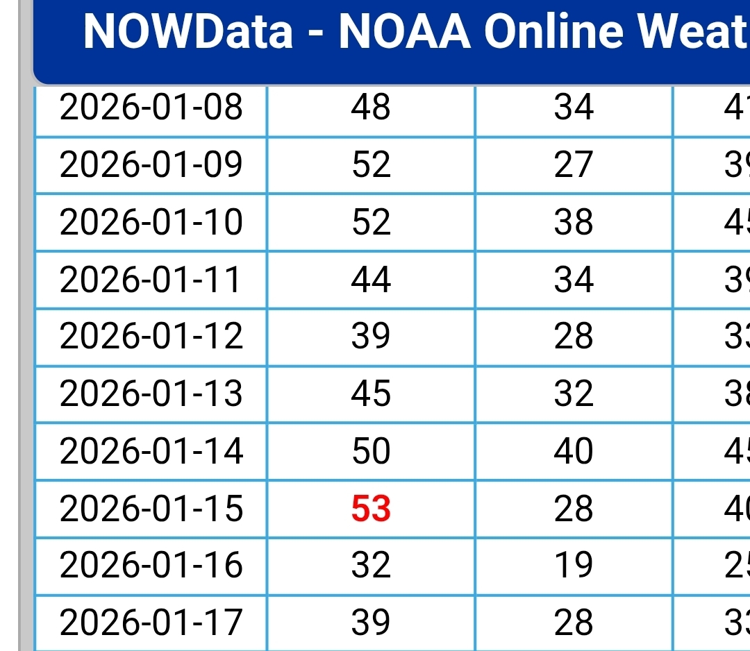
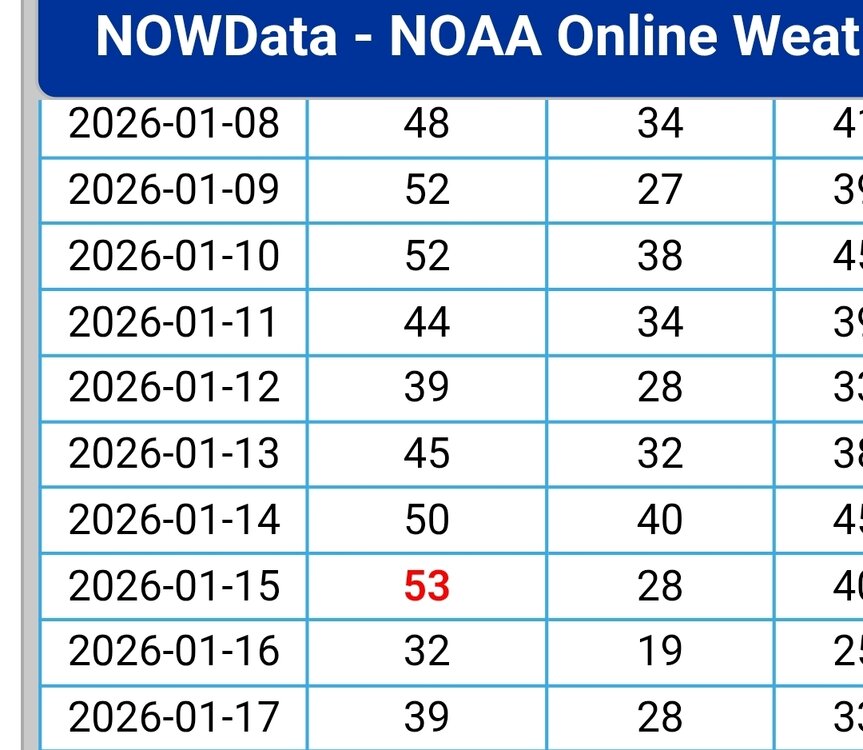
Wow…very impressive. So back on Wednesday the 21st…you guys didn’t go above 32? I think that’s the last day we did..when it started out in the single digits, but warned up to close to 40 that afternoon. Then it snowed that evening/night with a couple inches. But since then it hasn’t broke 32 here. So 13 days so far and counting. Quite the run for sure.
-
November huh?
-
You know ...I was giving that, that 'pre spring' aspect some thought. I know exactly what you mean as I have been seeing/wondering that too. However, I'm not sure if you or anyone might recall this but... nearing the end of that odd ball N. Pac blocking node between thanks giggedy and early early Jan, we were modeling something similar to this with periodic ultimately faux SE ridges ... We did mild up in there, but not very convincingly so before the era of -EPO kicked in. We've pulsed some 3 or 3.5 times with that index in the last 3 weeks since, and we've registered some decent wintry chill and at last a real snowfall out of it... Anyway, point is, I'm not sure this isn't some Charlie Brown set up for spring/warm enthusiasts just yet. I don't think there is a proper SSW intrusion --> down propagation event... but I think a low to up variant is certainly on the table, and it doesn't matter? really if you're doing that, your freezing your balls off either way... in fact, the top down version is probably less useful to winter enthusiasm ( just for the sake of discussion) because that time-lag's a killer going into March. It could just not show up when it is that late. But anyway, I definitely want to see some legs in the form of continuity in a warm appeal out there. Lord knows I want it... but just objectively
-
Less cold this weekend helps because the snow has increased both pre and prior to it . Now that the low digs south it snows more, allows for the core cold to go west and we snow / ice next week with no suppression.
-
lol... was easy enough to go look and see what happened... and I'm not even remotely surprised