All Activity
- Past hour
-
Wow. Down to 1.8 here
-
Richmond Metro/Hampton Roads Area Discussion
eaglesin2011 replied to RIC Airport's topic in Mid Atlantic
Thats all predicted to dry out once it passes the mountains.. Honestly just looking at the radar it looks like this whole storm will be a bust east of the NC Mountains and Charlotte Areas… looking at the radar currently you can clearly see how much moisture is out there but starting to die out when it passes this area because the coastal is talking away it’s energy and developing too far off the coast. In turn drying out everything west & nw of it… -

Jan 30th-February 1st 2026 Arctic Blast/ULL Snow OBS Thread.
John1122 replied to John1122's topic in Tennessee Valley
Looks like the band is beginning to sink into West Knoxville. Oak Ridge looks to be getting nailed currently. -

Jan 30th-February 1st 2026 Arctic Blast/ULL Snow OBS Thread.
John1122 replied to John1122's topic in Tennessee Valley
1am down to 17. I'll get very gusty winds that blow snow, and then it calms down for a while. It's mostly blown snow off the trees. -
January 30th- Feb 1st ULL and coastal storm obs
Snowncanes replied to JoshM's topic in Southeastern States
If that’s accurate, seems like it’s much closer to the coast than modeled? -

February 2026 Medium/ Long Range Discussion: Buckle Up!
Steve25 replied to Weather Will's topic in Mid Atlantic
It wasn’t far off from a couple systems swinging by, though. For whatever that’s worth. On another note, the regular Euro continues to be pretty unenthusiastic about any potential system next week -
February 2026 Medium/ Long Range Discussion: Buckle Up!
jayyy replied to Weather Will's topic in Mid Atlantic
Tuesday Night A chance of snow after 1am. Mostly cloudy, with a low around 18. Chance of precipitation is 30%. Wednesday A chance of snow. Mostly cloudy, with a high near 30. Chance of precipitation is 40%. Wednesday Night A chance of snow. Mostly cloudy, with a low around 18. Chance of precipitation is 30%. Current point click for next week -
1/30-1/31 Lake Effect Snow Threat - SE WI, NE IL, and NW IN
KeenerWx replied to A-L-E-K's topic in Lakes/Ohio Valley
Looks like primary threat zone shifted east a bit and now looks to center comfortably in Porter County or perhaps even on the line between Porter & LaPorte. Maybe even a bit questionable the extent of plume organization overnight, but of course, even a couple hours of LE can add up. -
Richmond Metro/Hampton Roads Area Discussion
wasnow215 replied to RIC Airport's topic in Mid Atlantic
Radar showing returns in southern Va not on any models -interesting -
Jan 30th-February 1st 2026 Arctic Blast/ULL Snow OBS Thread.
Hurricaneguy replied to John1122's topic in Tennessee Valley
Decent band moving over Greeneville. Rates have increased in the last 15 mins. -

E PA/NJ/DE Winter 2025-26 Obs/Discussion
snowwors2 replied to LVblizzard's topic in Philadelphia Region
Correct per my last post‼️ -

Jan 30th-February 1st 2026 Arctic Blast/ULL Snow OBS Thread.
John1122 replied to John1122's topic in Tennessee Valley
I can't tell which way it's going but the band that sat over me and dumped on me looks like it's made it's way down to Oak Ridge and Clinton. If it's sinking south, it should over take Knoxville soon. -

E PA/NJ/DE Winter 2025-26 Obs/Discussion
snowwors2 replied to LVblizzard's topic in Philadelphia Region
Already down to -3.1° at 1:00 AM‼️ -

E PA/NJ/DE Winter 2025-26 Obs/Discussion
snowwors2 replied to LVblizzard's topic in Philadelphia Region
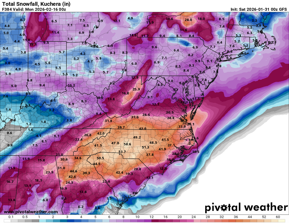
That’s the good ‘ol GFS for ya‼️ -
I can’t take this all winter. It’s too stressful lol
-
The “I bring the mojo” Jan 30-Feb 1 potential winter storm
Snowncanes replied to lilj4425's topic in Southeastern States
So I’ve done some digging into the models here recently and I don’t think im entirely buying the dry air thing. Our DGZ is saturated, the 600-850mb layer is saturated, we really are only dry from the 925mb layer down. And that is sitting at about 50-60%RH. I don’t think that will be too hard to overcome and we can wetbulb down to saturated at the ground. Could it eat into our totals for an hour? Sure. Is it going to be as bad as the models think? I don’t think so. We are already seeing snow falling that the models Didnt pick up on. Yes we are between the two areas of greatest forcing but i think the surface low will overpreform and push that out of the way. I just can’t imagine a 970mb low having that small of a precip shield with a negatively tilted 500mb upper low. Im not a met, but I have tracked storms my whole life, so if I’ve missed something please correct me. But thats my two cents. -
Central PA Winter 25/26 Discussion and Obs
Ruin replied to MAG5035's topic in Upstate New York/Pennsylvania
This has to be one of the longest cold snaps in the last 20 years. while it may not be the coldest we ever had its pretty long lived. I havent seen snow stick around and hardly melt for a week like this last storm in a long time. -
Flakes here too. Off to get some sleep
-
That's after two storms lol crazy
-
Pittsburgh/Western PA WINTER ‘25/‘26
SteelCity87 replied to Burghblizz's topic in Upstate New York/Pennsylvania
Brought the midweek threat back north a bit. Certainly looks to be a very active period -

Jan 30th-February 1st 2026 Arctic Blast/ULL Snow OBS Thread.
Stovepipe replied to John1122's topic in Tennessee Valley
Looks like it's trying to form a line that will move across several counties. -
.thumb.jpg.9707d4addca3d84715ae3d888c5c10d6.jpg)
Jan 30th-February 1st 2026 Arctic Blast/ULL Snow OBS Thread.
Bigbald replied to John1122's topic in Tennessee Valley
It is pretty cool to think the whole synoptic of the storm will show itself in the next 2 hrs, or at least from our perspective. Kind of wild! -
January 30th- Feb 1st ULL and coastal storm obs
BG_Slick replied to JoshM's topic in Southeastern States
Still snowing. Has continued to be light. Picking up in intensity a little bit now -

The “I bring the mojo” Jan 30-Feb 1 potential winter storm
QC_Halo replied to lilj4425's topic in Southeastern States
Can I send the women I live with your way? -

Pittsburgh/Western PA WINTER ‘25/‘26
colonel717 replied to Burghblizz's topic in Upstate New York/Pennsylvania


