All Activity
- Past hour
-
-
Warm nose is not affecting your area. Just the other side of NJ. Trenton will mix before you.
-
Still getting a lot of snow mixing in. It's a day of continuous false weenie hope. Lol
-

Central PA Winter 25/26 Discussion and Obs
anotherman replied to MAG5035's topic in Upstate New York/Pennsylvania
Coastal might help with that. -
Faster in PA than NJ is good short term if you want delayed changeover but bad long term as it means primary still kicking. Either way blasting snow now so just enjoy.
-

January 25-26 Winter Storm Potential
MattMal88 replied to Ralph Wiggum's topic in Philadelphia Region
Still puking snow in NE Philly. Did my 1st rd of shoveling and have over an inch where I started before I got done in less than an hr. CC radar looks weird. Sleet to the west and WNW of me but still all snow and heavy here. Measured 5 inches before I started shoveling, has to be over 6 now. This thump is pretty sweet. -
Unprecedented sleet avalanches falling off my roof when the wind gusts. Like waterfalls outside the windows. Better on the ground than up there though
-
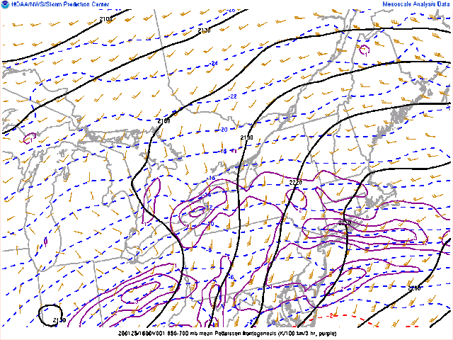
 Dont see a map like this every day.
-
9 inches in glen rock nj - we are on our way to way more than a foot
-

Pittsburgh/Western PA WINTER ‘25/‘26
RitualOfTheTrout replied to Burghblizz's topic in Upstate New York/Pennsylvania
Measured about 7 a half hour ago. Still ripping heavy snow. -

January 24-26: Miracle or Mirage OBS Thread!
Stormchaserchuck1 replied to Jebman's topic in Mid Atlantic
Heavy sleet, 14F. I just measured 7.8" of snow/sleet. -
 Closing in on 4" real soon. @Damage In Tolland how does that line up with what you have? I'm near the Tolland/Coventry border.
 -
In a region not experiencing either warming or cooling you would expect a gradual and coupled decline in both daily high and low record temperature reports since each report becomes increasingly less likely. But what we see in the graph you posted is a decoupling such that record low reports have significantly declined while record highs reports are coming in at roughly the same rate for last several decades. This is consistent with that region experience long term secular warming.
-
Just under 5”.
-

Extreme Cold, Snow & Sleet: SECS 1/24 - 1/26
nycsnow replied to TriPol's topic in New York City Metro
Looks like south shore of Long Island is getting into some of that ocean enhanced snow as well -

Southern Crippler - Get well soon Jimbo Storm Obs
gman replied to BooneWX's topic in Southeastern States
24 degrees. Sleet coming down the hardest I’ve seen so far. -

Central PA Winter 25/26 Discussion and Obs
Blizzard92 replied to MAG5035's topic in Upstate New York/Pennsylvania
There are some indications in recent radar frames that the mix line may be slowing down or retreating south a bit in parts of Bedford County as some colder air filters in. -
That dryslot in southern NJ bugs me, I'm more concerned about that now than the mixing line. Either way, this storm has been amazing with 6" OTG and heavy snow continuing.
-

Southern Crippler - Get well soon Jimbo Storm Obs
Met1985 replied to BooneWX's topic in Southeastern States
The NAM shit the bed on thermals. Absolutely atrocious. -

Central PA Winter 25/26 Discussion and Obs
WX-PA replied to MAG5035's topic in Upstate New York/Pennsylvania
Snow and sleet here in Dillsburg..but it is still accumulating -
 3.5” down .. 30” to go
 -
Gotta clean out my attachments. Will post more later
-
I think it reaches between I-80 & the NY/NJ border. Where exactly remains to be seen