All Activity
- Past hour
-
Had a low of 29.7° this morning.
-
Wondering if that heat in the West coast then makes it to the southeast mid November. More than likely.
-
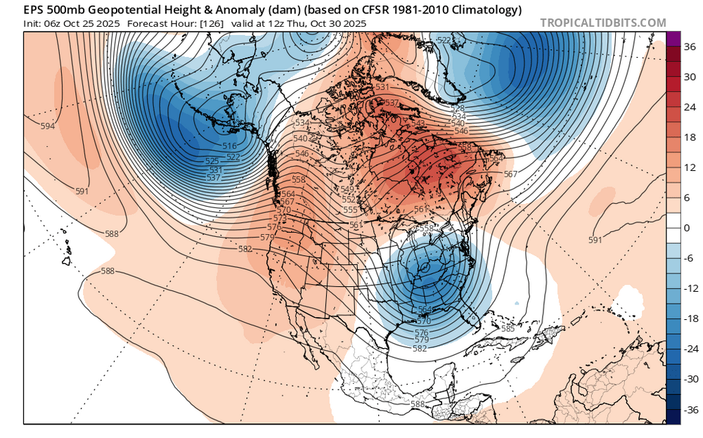
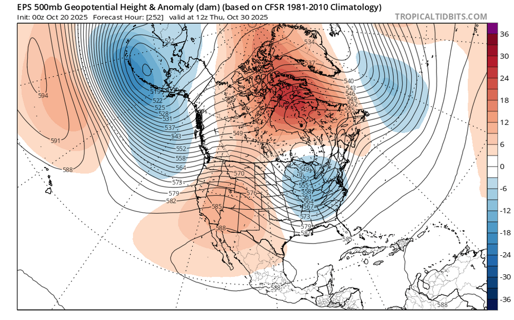
Warmer storm track on the latest EPS with the low now tracking to our west instead of the east in earlier runs. We have seen this quite a bit in recent years. Have been getting warmer storm tracks even with -NAO and +PNA patterns. The WAR is a little stronger than earlier runs. New run stronger WAR linking up with the Greenland block Old run weaker WAR
-
38 Columbia imby Saturday morning.
-

Spooky Season (October Disco Thread)
Sey-Mour Snow replied to Prismshine Productions's topic in New England
That was close to something much more -
I want them to 3-peat going into the 2026 lockout/strike so we get a salary cap/floor in MLB.
-

Spooky Season (October Disco Thread)
Snowcrazed71 replied to Prismshine Productions's topic in New England
Well this morning was the first morning that all of the roofs on my street had frost on them. It's funny, I'm higher up on the hill but a few houses down from me and as I go down, the roofs on the house is is seem to be more frosty than up where I was. It's the whole valley thing I guess LOL. -
Not yet: BULLETIN Tropical Storm Melissa Advisory Number 17 NWS National Hurricane Center Miami FL AL132025 1100 AM EDT Sat Oct 25 2025 ...MELISSA NEAR HURRICANE STRENGTH AND FORECAST TO RAPIDLY INTENSIFY THIS WEEKEND... ...LIFE-THREATENING AND CATASTROPHIC FLASH FLOODING AND LANDSLIDES EXPECTED IN PORTIONS OF SOUTHERN HISPANIOLA AND JAMAICA THROUGH THE WEEKEND... SUMMARY OF 1100 AM EDT...1500 UTC...INFORMATION ----------------------------------------------- LOCATION...16.5N 75.1W ABOUT 155 MI...245 KM SE OF KINGSTON JAMAICA ABOUT 235 MI...375 KM SW OF PORT AU PRINCE HAITI MAXIMUM SUSTAINED WINDS...70 MPH...110 KM/H PRESENT MOVEMENT...WNW OR 285 DEGREES AT 1 MPH...2 KM/H MINIMUM CENTRAL PRESSURE...982 MB...29.00 INCHES
-

Spooky Season (October Disco Thread)
tamarack replied to Prismshine Productions's topic in New England
Low of 31, sometime in the wee hours. Had light RA at 11:30 last evening (0.07") and mostly cloudy at 7 this morning. Must've cleared for a few hours between. -
Low of 35.6 here. Currently 48.7
-
The only way to determine whether a lack of weather ballon data is causing a specific model error is to do a data denial experiment which is impossible without the data. https://www.cnn.com/2025/10/14/weather/alaska-storm-weather-balloons-trump-cuts-nws-climate How big of a difference the missing balloon data made, though, may never be known. The best way to determine that would be to run computer models with weather balloon data fed into them and without it, in what is known as a data denial experiment — impossible to do without the data itself.
-
Local station reports low of 32/32, fog over the Connecticut River, now burned off, 38F and clear as a bell!
-
Watch the next 2 weeks. GEFS pulling the Ole 21-22/22-23/23-24 thing D12 plus right now where it says nahhh you don't to the GEPS/EPS regarding the Pacific. It did that at times last winter too but due to the poleward AK ridge it was wrong almost every if not every time. This could give us some idea where this winter is going, at least early if the GEPS/EPS end up winning this one if it remains a persistent difference in the models the next few days. I will say that over the last 10 days or so all of the ensembles have somewhat lost the battle as we are definitely still much more GOA/AK vortex heavy than we were on their forecasts back 10 days ago, so they certainly rushed the change.
- Today
-
33, frost
-

Central PA Fall Discussions and Obs
Superstorm replied to ChescoWx's topic in Upstate New York/Pennsylvania
36F here. I assume many of the lower lying areas went below freezing. Growing season is over there. . -
Sept had some notable action as far as temps, and precip, but what a slow, mellow Oct. Well, here's to a active Nov
-

Spooky Season (October Disco Thread)
HoarfrostHubb replied to Prismshine Productions's topic in New England
First time this season I saw frost on my roof. It was colder one other morning but no frost that day -

Spooky Season (October Disco Thread)
DavisStraight replied to Prismshine Productions's topic in New England
Had to deice my windshield this morning, im in Mass this weekend, probably cooler in Maine. -
Didn't we have a massive NF warm pool in Nov/Dec 2000 though? I think that its more the lack of a 50/50 low for some reason that we keep seeing that. We saw it less often last winter however when we had the -NAO because that vortex was there to prevent it from happening.
-
.thumb.png.0012268e273402dcfb9866a0a1e919a3.png)
-
35
-

Spooky Season (October Disco Thread)
CT Valley Snowman replied to Prismshine Productions's topic in New England
Low of 31. Lowest of the season has been 28. -
low of 41F at 6:48. No sign of frost
-
Thats not too surprising given the recent combo of a strong west based -NAO and AK vortex flooding W Canada with mild air. This pattern this month as far as Pac/ATL is about as close to December 2001 or 2012 as you can get.
-
So happy to see the Dodgers get smacked around last night.


.png.caaa14f1fcdeb3ff44ec2366048a1e6d.png)


