All Activity
- Past hour
-
I remember that well. The hype from JB in mid-late February was off the charts that winter. He was calling for a record-breaking cold and snowy March in the east, “March Madness!” and was using 1888, 1958, 1960 and 1993 as the analogs
-
I never stated my confidence level. I'm merely stating what the study indicated. The aspects about taut/tension in the system is pure logic after the fact.
-
I marvel at your apparent confidence in research that proclaims to cover periods of time stretching back 100's of millions of years. It's a bold stance and you do it with conviction.
-
And LA
-
Heat out west So Cal
-
The cold air disappeared that year--storms raged all of march was too bad some areas could have put up another 20-30 inches of snow had it been colder
-
Clouds moved in again and prevented us from bottoming out, only got to 34.3 here
-
I want a hit, even though it’d be inconvenient for me personally haha. I’m just shy of 150” in my first season here! The basement held together beautifully after the rapid snow melt so I’m ready for as much as we can get. It’s funny—in CT I’m ready for spring but up here I’ll be ready April 1.
-
I know that showing the sharp cutoff can be tough if you don't have enough reports but I only had .4 on the board for that one. Not 4" but .4, a terrible bust for my neck of the woods due to one of the sharpest cutoffs I've recorded.
-
Not in all areas. Philly and the mid-Atlantic got some good snow, and even the areas that got shut out of snow were still well below average temperaturewise. If you want a shutout March, look at 09/10. Winter just suddenly stopped once the calendar flipped to March 1. The entire spring and summer was well above average.
-
Good point although the good possibility of Phoenix approaching if not reaching 105, the hottest on record in April, during some point within the next 3 days is amazing. But Don, myself, and others realize that their rapid growth’s caused increasing UHI has also been a notable factor. Speaking of UHI though, isn’t that more of a factor for warm lows than hot highs?
-
I always go back to Will/ORH's logic from the past two decades... might as well enjoy the weather hobbyist excitement of snowfall and root for it, because it's not going to magically be 70F and sunny instead. If the alternative to it snowing is a 35.7F degree, one inch of rainfall, it's sort of why not go for snow, provided you don't have to drive three hours in it or something. It'll melt soon enough. Either way it's going to get muddy, be it during an inch of cold rain or after the snow melts, guess the cold rain it just is muddy sooner, ha.
-
Low of 36.
-
It’s just computer generated bullshit. I don’t even look at that junk anymore…unless I just want a VERY general idea of what might happen. It’s mostly Garbage.
-

Occasional Thoughts on Climate Change
WolfStock1 replied to donsutherland1's topic in Climate Change
50 states x 12 months = 600 records for "highest temperature for state X during month Y". To be honest - breaking one of those every now and then seems like not so much of a big deal, and would be expected regardless of whether the planet is warming or not. Point being - perhaps showing trendlines of more broad data would be a lot more meaningful and poignant that touting a given broken single-state record for a given month. As it is these posts with their desert graphics, and the obvious troll phrasing, seem very... tabloidish (or perhaps clickbait-ish being the modern equivalent), especially on a forum that thrives on deep data analysis. -
Hope and pray for what? That it misses? That is what I would be hoping for. I really don't want 22" and yes, I know it wouldn't play out like that but now that I've melted out, I want the progression towards the warm season to continue unabated.
-
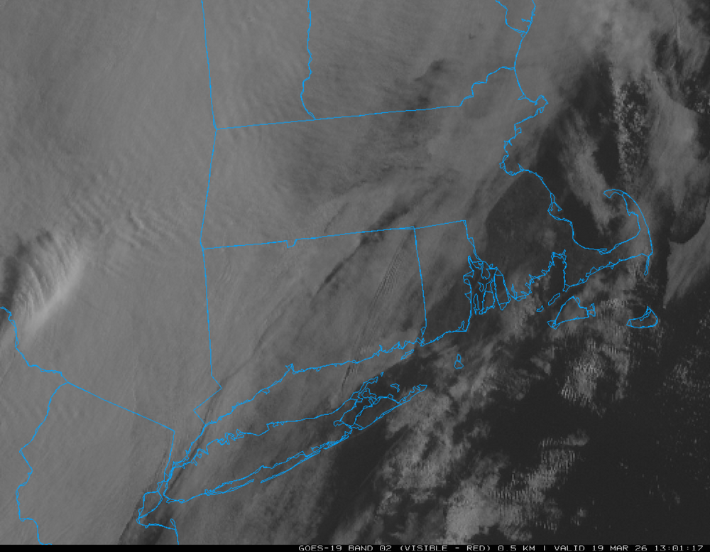
yep looks socked in rest of the day unless it burns off
-
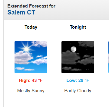
How do they get this so wrong so many times: With all these clouds moving in from the west. "Mostly Sunny", really???
-
Even the sun makes the cold feel kinda warm at this point... still wouldn't mind biking to work without being bundled up!
-
The Great Filter. Coming soon to a civilization near you.
-
Lower 30s snow wise? RFD escaped sub 30 club barely with latest March snowfalls totalling 6.8". Although areas around RFD received more from blizzard in the 7-10" range.
- Today
-
Of course I never met Roger, but what stands out to me is how I feel like I really know a person based on content shared on this board. Everything I learned about Roger based on his posts tells me that he was a good, kind and smart man. His time on Earth was well spent as he shared his time and talents with others! We must all remember that our time here is short and we should do our best to make the most of every moment and to give of ourselves to the greater good of others. Live long and Prosper Roger!
-
Convective inner eyewall snow squalls? Sign me up
-
Records: Highs: EWR: 77 (2012) NYC: 76 (1918) LGA: 72 (2012) JFK: 69 (2010) Lows: EWR: 8 (1967) * coldest reading post Mar 15th on record at Newark NYC: 8 (1967) LGA: 10 (1967) JFK: 7 (1967) Historical: 1907: The highest March temperature in Oklahoma City, Oklahoma, was set when the temperature soared to 97 degrees. Dodge City, Kansas, also set a March record with 98 degrees. Denver, Colorado, set a daily record high of 81 degrees. 1935 - Suffocating dust storms occurred frequently in southeastern Colorado between the 12th and the 25th of the month. Six people died, and many livestock starved or suffocated. Up to six feet of dust covered the ground. Schools were closed, and many rural homes were deserted by tenants. (The Weather Channel) 1948: An estimated F4 tornado moved through Fosterburg, Bunker Hill, and Gillespie, Illinois, killing 33 people and injuring 449 others. 2,000 buildings in Bunker Hill were damaged or destroyed. The total damage was $3.6 million. 1950 - Timberline Lodge reported 246 inches of snow on the ground, a record for the state of Oregon. (The Weather Channel) 1956 - The second heavy snowstorm in just three days hit Boston. Nearby Blue Hill received 19.5 inches contributing to their snowiest March of record. (David Ludlum) 1958: The storm began as a weak area of low-pressure just east of Norfolk, Virginia or a coastal storm. Naked Creek in Rockingham Co., Virginia had a total of 3.0 inches and Dale Enterprise in Rockingham Co., Virginia had but a trace of snow. Much of the precipitation that fell in the Washington area as rain but finally during the late evening of the 19th the precipitation changed over to heavy snow. The dense flakes fell rapidly through the rest of the night and into the morning of the 20th and by noon, the worst of the storm was over, but periods of light to moderate snow continued on into the morning of the 21st. The interesting feature of this storm was extreme amount of water content. National Airport recorded a water content of 3.75 inches and some stations reported over 5 inches of liquid content. The snowfall total at National Airport was only 4.8 inches of wet snow. Arlington had a foot of snow. In the Maryland suburbs, 9 inches fell in Greenbelt; 11 inches in Silver Spring; 15 inches fell at Fort Meade; and 16 inches fell at Bethesda. Much of the Upper Montgomery County and Howard County received over 20 inches and Mt. Airy, Maryland had 33 inches of snow. Morgantown total of 50" is not a fluke...Morgantown, at 750' in elevation at the borders of Chester, Berks, and Lancaster Counties in Southeast Pennsylvania, set a record for snowfall in the immediate area. This area saw significant snowfall from a low pressure center that was cut off from the main steering pattern in the atmosphere, with snows continuing to pile up across a narrow band along the ridge tops. Southeast Pennsylvania and across the Poconos in Northeast Pennsylvania, where Stroudsburg received 35.4" of snow from the storm. Weather Map for March 20, 1958(Ref. NWS) (Ref. (p. 69-70 Washington Weather Book 2002 by Ambrose, Henry, Weiss) Ref. (NWS Ranking for Storms between 1956 and 2011) This is the 31st Worst Snowstorm 1959: A major storm dumped heavy snowfall of 7.7 inches at Stapleton Airport in Denver, CO where north winds gusting to 45 mph caused blowing and drifting. Many highways were blocked with damage to telephone lines along the South Platte River. The storm started a rain and changed to heavy wet snow which froze on the lines causing them to break. The storm was responsible for two deaths across eastern Colorado. (Ref. Wilson Wx. History) 1969: High winds buffeted the front range foothills in eastern Colorado causing damage in Boulder and Jefferson counties. A freight train was derailed near the entrance to a canyon 20 miles west of Denver when some empty cars were caught on a curve by a wind gust. Two small planes were heavily damaged at the Jefferson County airport. Winds gusted to 105 mph at the National Center for Atmospheric Research in Boulder, 62 mph in downtown Boulder, and 80-90 mph at the Boulder airport. Stapleton Airport in Denver reported a gust to 49 mph. (Ref. Wilson Wx. History) 1987 - A storm in the western U.S. produced rain and snow from the northern and central Pacific coast to the northern and central Rockies. Heavier snowfall totals included 13 inches at Clear Creek UT, 12 inches at Snow Camp CA and Glacier Park MT, and 10 inches at Kayenta AZ. Wind gusts reached 54 mph at Winslow AZ. (The National Weather Summary) (Storm Data) 1988 - Seven cities in California and Nevada reported record high temperatures for the date as readings soared into the 80s and lower 90s. Los Angeles CA reported a record high of 89 degrees. Five cities in south central Texas reported record lows, including El Paso, with a reading of 22 degrees. (The National Weather Summary) 1989 - Six cities reported new record low temperatures for the date as cold arctic air settled into the Upper Midwest for Palm Sunday, including Marquette MI with a reading of 11 degrees below zero. (The National Weather Summary) 1990 - Rather wintry weather in the eastern U.S. replaced the 80 degree weather of the previous week. Freezing temperatures were reported in northern sections of the Gulf Coast States, and snow began to whiten the Northern and Central Appalachians. Up to eight inches of snow was reported in western Virginia. (Storm Data) (The National Weather Summary) 2003 - Denver digs out from the second-biggest snowstorm in the city's history. Almost two and a half feet of wet snow over 36 hours shuts down the city. The month ends as Denver's snowiest March on record. 2003: One of the worst blizzards since records began in 1872, struck the Denver metro area and Colorado's Front Range started with a vengeance. Denver International Airport was closed, stranding about 4,000 travelers. The weight of the snow caused a 40-foot gash in a portion of the roof, forcing the evacuation of that section of the main terminal building. Winds gusting to 40 mph produced drifts six feet high in places around the city. Snowfall in foothills was even more impressive. The heavy wet snow caused numerous roofs of homes and businesses to collapse. The estimated cost of property damage alone, not including large commercial buildings, was $93 million, making it the most costly snowstorm on record for the area. In Denver alone, at least 258 structures were damaged. Up to 135,000 people lost power during the storm, and it took several days for power to be restored. Mayor Wellington Webb of Denver said, "This is the storm of the century, a backbreaker, a record-breaker, a roof breaker." Avalanches in the mountains and foothills closed many roads, including Interstate 70, stranding hundreds of skiers and travelers. The Eldora Ski area 270 skiers were stranded when an avalanche closed the main access road. After the storm, a military helicopter had to deliver food to the resort until the road could be cleared. Two people died in Aurora from heart attacks after shoveling the heavy wet snow. The National Guard sent 40 soldiers and 20 heavy-duty vehicles to rescue stranded travelers along a section of I-70. The storm made March 2003 the snowiest March on record, the fourth snowiest month on record, and the fifth wettest March on record. The total of 22.9 inches is the most significant 24-hour total in March. The storm also broke 19 consecutive months of below-average precipitation for Denver. The 31.8 inches of snow was recorded at the former Stapleton Airport in Denver for its second-greatest snowstorm on record (the greatest was 37.5 inches on 12/4-12/5/1913) with up to three feet in other areas in and around the city and more than seven feet in the foothills. Higher amounts included: Fritz Peak: 87.5 inches, Rollinsville: 87.5 inches, Canin Creek: 83 inches, Near Bergen Park: 74 inches, Northwest of Evergreen: 73 inches, Cola Creek Canyon: 72 inches, Georgetown: 70 inches, Jamestown: 63 inches, Near Blackhawk: 60 inches, Eldora Ski Area: 55 inches, Ken Caryl Ranch: 46.6 inches, Aurora: 40 inches, Centennial: 38 inches, Buckley AFB: 37 inches, Southwest Denver: 35 inches, Louisville: 34 inches, Arvada: 32 inches, Broomfield: 31 inches, Westminster: 31 inches and Boulder: 22.5 inches. This storm was the result of a very moist intense slow-moving Pacific system that tracked across the four corners and into southeastern Colorado, which allowed a deep easterly upslope to form among the front-range. 2012: Chicago-O'Hare • This was the sixth consecutive day the record high was at least tied. (Ref. NWS)
-

Mid-Long Range Discussion 2026
WinstonSalemArlington replied to BooneWX's topic in Southeastern States
Frozen Palm Sunday


