All Activity
- Past hour
-
NEW YORK... 1130 AM EST FRI FEB 26 1999 THIS IS THE FINAL STATEMENT ON THIS EVENT. MONTAUK SUFFOLK 13.5 730 AM EAST HAMPTON SUFFOLK 10.0 700 AM SHINECOCK SUFFOLK 8.5 730 AM BRIDGEHAMPTON SUFFOLK 8.5 700 AM ORIENT POINT SUFFOLK 8.0 700 AM NWS OFFICE BROOKHAVEN SUFFOLK 6.4 700 AM PATCHOGUE SUFFOLK 5.9 700 AM RIDGE SUFFOLK 5.0 730 AM MOUNT SINAI SUFFOLK 4.7 700 AM FARMINGVILLE SUFFOLK 4.6 800 AM SOUTH SETAUKET SUFFOLK 4.5 800 AM RONKONKOMA SUFFOLK 4.0 700 AM ISLIP SUFFOLK 3.0 700 AM CENTERPORT SUFFOLK 2.8 800 AM FARMINGDALE NASSAU 2.0 700 AM OCEANSIDE NASSAU 1.8 600 AM NORTH MASSAPEQUA NASSAU 1.5 700 AM LA GUARDIA AP QUEENS 2.0 700 AM KENNEDY AP QUEENS 1.0 700 AM GRAVES END BROOKLYN KINGS 1.2 800 AM CENTRAL PARK NEW YORK 1.5 700 AM WHITE PLAINS WESTCHESTER 1.3 700 AM
-

The Jan 31 Potential: Stormtracker Failure or 'Tracker Trouncing
stormtracker replied to stormtracker's topic in Mid Atlantic
Next -

The Jan 31 Potential: Stormtracker Failure or 'Tracker Trouncing
Kay replied to stormtracker's topic in Mid Atlantic
In order to model good pbp manners for all the new and infrequent posters -

Richmond Metro/Hampton Roads Area Discussion
jlewis1111 replied to RIC Airport's topic in Mid Atlantic
ahh I got fooled with the ai lol -
I mean look-we have 10+ inches of hardened snow on the ground and huge piles in every parking lot that will last into March, and bays/rivers all freezing over. If this one misses there will be another. It’s as deep winter here as you could ever ask for.
-

The Jan 31 Potential: Stormtracker Failure or 'Tracker Trouncing
ravensrule replied to stormtracker's topic in Mid Atlantic
You're much better looking, I would have been extremely insulted. -

1-30/2-1-26 Arctic Blast, ULL Snow Event
Daniel Boone replied to John1122's topic in Tennessee Valley
I think MRX is too high on Forecasted Temps Saturday and Sunday. They're adjusting to Climatology looks like as Guidance looks colder. -
 If we all knew what the models were going to do ahead of time, none of us would be here
 -

The Jan 31 Potential: Stormtracker Failure or 'Tracker Trouncing
Nomz replied to stormtracker's topic in Mid Atlantic
At initialization and f30 its the slightest bit west, but nowhere near enough to get us in striking distance -

February 2026 Medium/ Long Range Discussion: Buckle Up!
Maestrobjwa replied to Weather Will's topic in Mid Atlantic
Man that would feel worse somehow...to miss out on a Miller A and have to settle for pity flakes from an unreliable Miller B? Ehhhh... -

Possible coastal storm centered on Feb 1 2026.
dryslot replied to Typhoon Tip's topic in New England
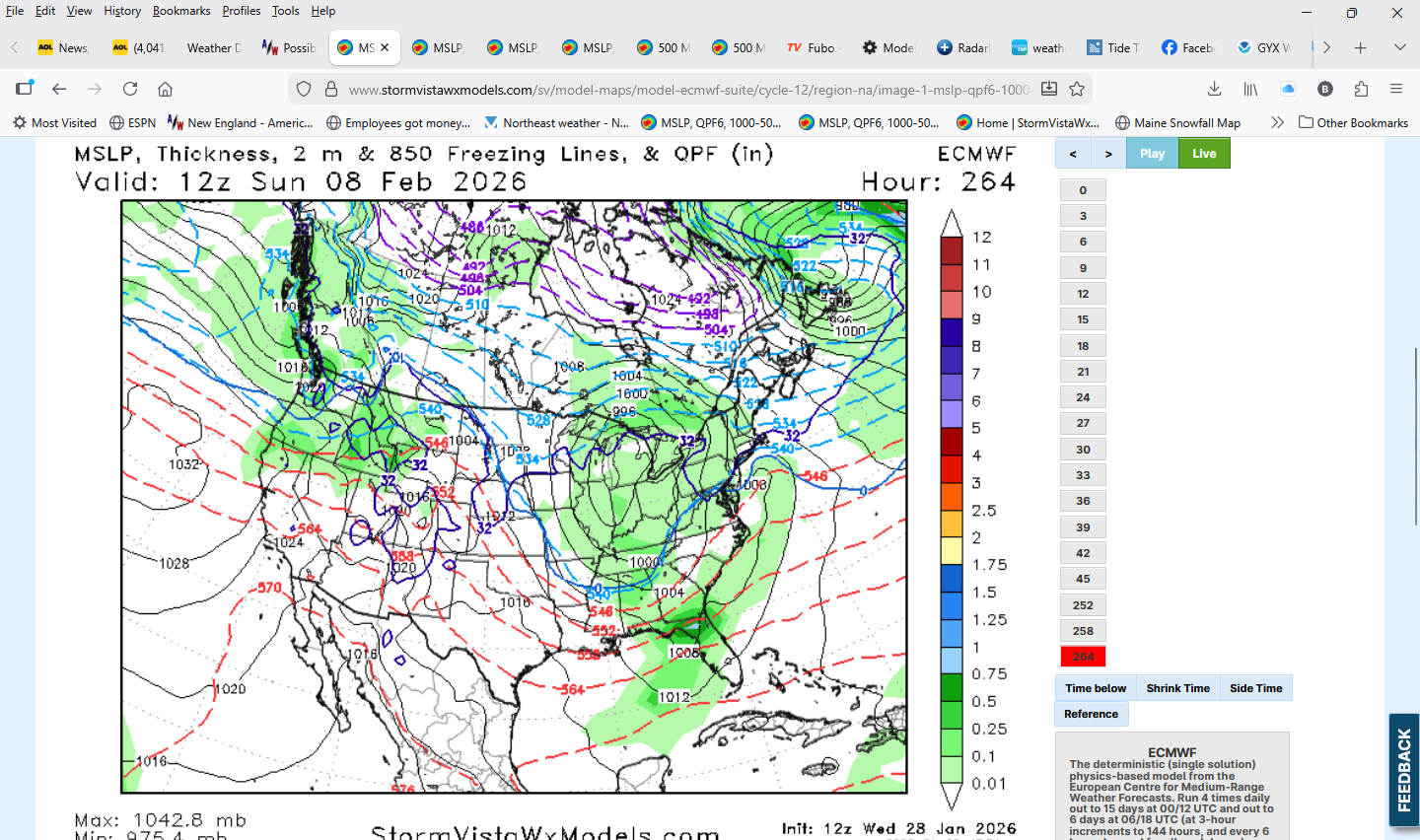
Euro all a mess lol goes from hr 45 to hr 252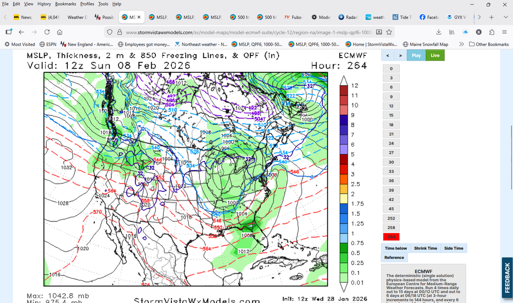
-

Pittsburgh/Western PA WINTER ‘25/‘26
southpark replied to Burghblizz's topic in Upstate New York/Pennsylvania
I just had to flag down my mail person since they can't reach our box because of how they plowed around my mailbox. -
How different is it from 06z? I feel like it hasn’t been firmly in the camp with GFS and CMC. It’s made steps towards those solutions, but is still barely on the outside looking in.
-

E PA/NJ/DE Winter 2025-26 Obs/Discussion
RedSky replied to LVblizzard's topic in Philadelphia Region
This is all covered in the weenie handbook chapter 12 historic cold periods are dry and dull with the proverbial lull, old timers will say "it's too cold to snow" -

Possible coastal storm centered on Feb 1 2026.
Damage In Tolland replied to Typhoon Tip's topic in New England
Compact? I think it’s just the opposite . It’s a winter hurricane in size and scope. So think of it in terms of a growing and expanding extra tropical storm but in winter with far reaching effects -
 4 years ago tomorrow was the 2nd greatest blizzard of my life. 9 hrs of less than an 1/8 th mile visibility drifting 8 to 10 feet. Death band for hours
 -
February 2026 Medium/ Long Range Discussion: Buckle Up!
Nomz replied to Weather Will's topic in Mid Atlantic
Euro AIFS again has that Miller B around f200 that gives us an inch or two -

February 2026 Medium/ Long Range Discussion: Buckle Up!
osfan24 replied to Weather Will's topic in Mid Atlantic
There is a chance for this to be an epic winter but we are going to have to start picking it up in the snow department to get there. Most are probably around or slightly ahead of climo to date. Throw in the serious cold for nearly the entire winter and this could really rival our best winters over several decades IF we can get clobbered once or twice. -

Richmond Metro/Hampton Roads Area Discussion
RVASnowLover replied to RIC Airport's topic in Mid Atlantic
rolling in now -
The Euro is probably not going to be very good for areas along and west of 75. Hopefully it's wrong, but it's usually only wrong when it shows significant snow.
- 74 replies
-
- 2
-

-
- extreme cold
- snow
- (and 1 more)
-

The Jan 31 Potential: Stormtracker Failure or 'Tracker Trouncing
Interstate replied to stormtracker's topic in Mid Atlantic
Why. It is going to be a big miss too -
The Jan 31 Potential: Stormtracker Failure or 'Tracker Trouncing
Maestrobjwa replied to stormtracker's topic in Mid Atlantic
When I saw you pop back in I figured it had finally started running, lol I mean not that we're expecting too much but still -
The Jan 31 Potential: Stormtracker Failure or 'Tracker Trouncing
stormtracker replied to stormtracker's topic in Mid Atlantic
Anyway, so far..Euro about the same as 6z -
Exactly and this is what to look for going forward around our Back yards.