All Activity
- Past hour
-
Just saw it. lol. That model.
-
12z? 6z was liquid to Laconia. What a model.
-

December 2025 Short/Medium Range Forecast Thread
jaxjagman replied to John1122's topic in Tennessee Valley
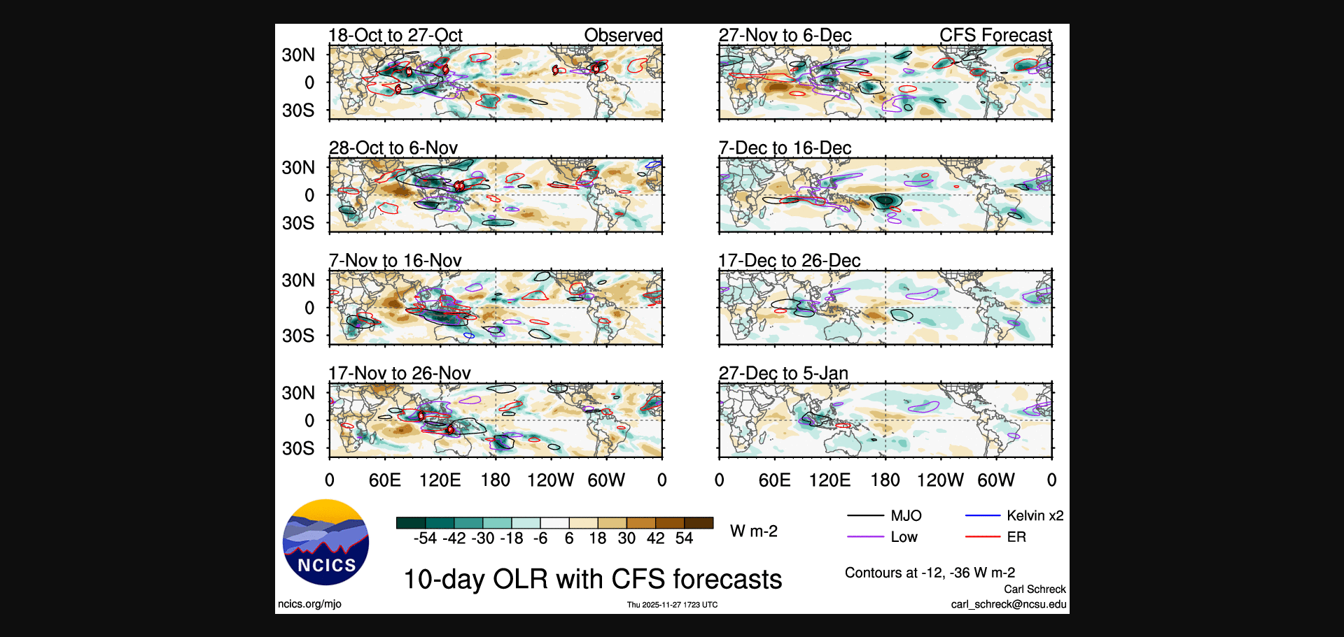
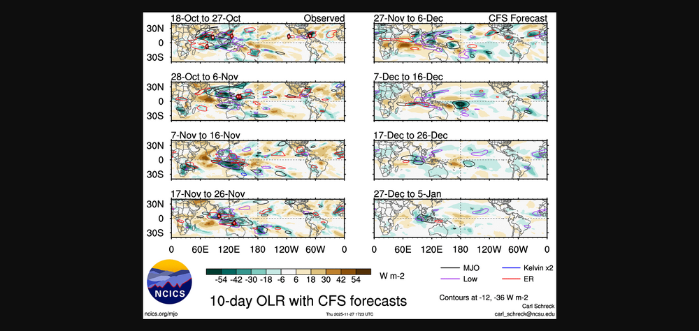
The MJO was fairly chaotic into Maritime/WP this cycle but it was into still the Maritome the first week of Nov,i need to go back and read it more thoroughly for myself,thanks for sharing this,John
-
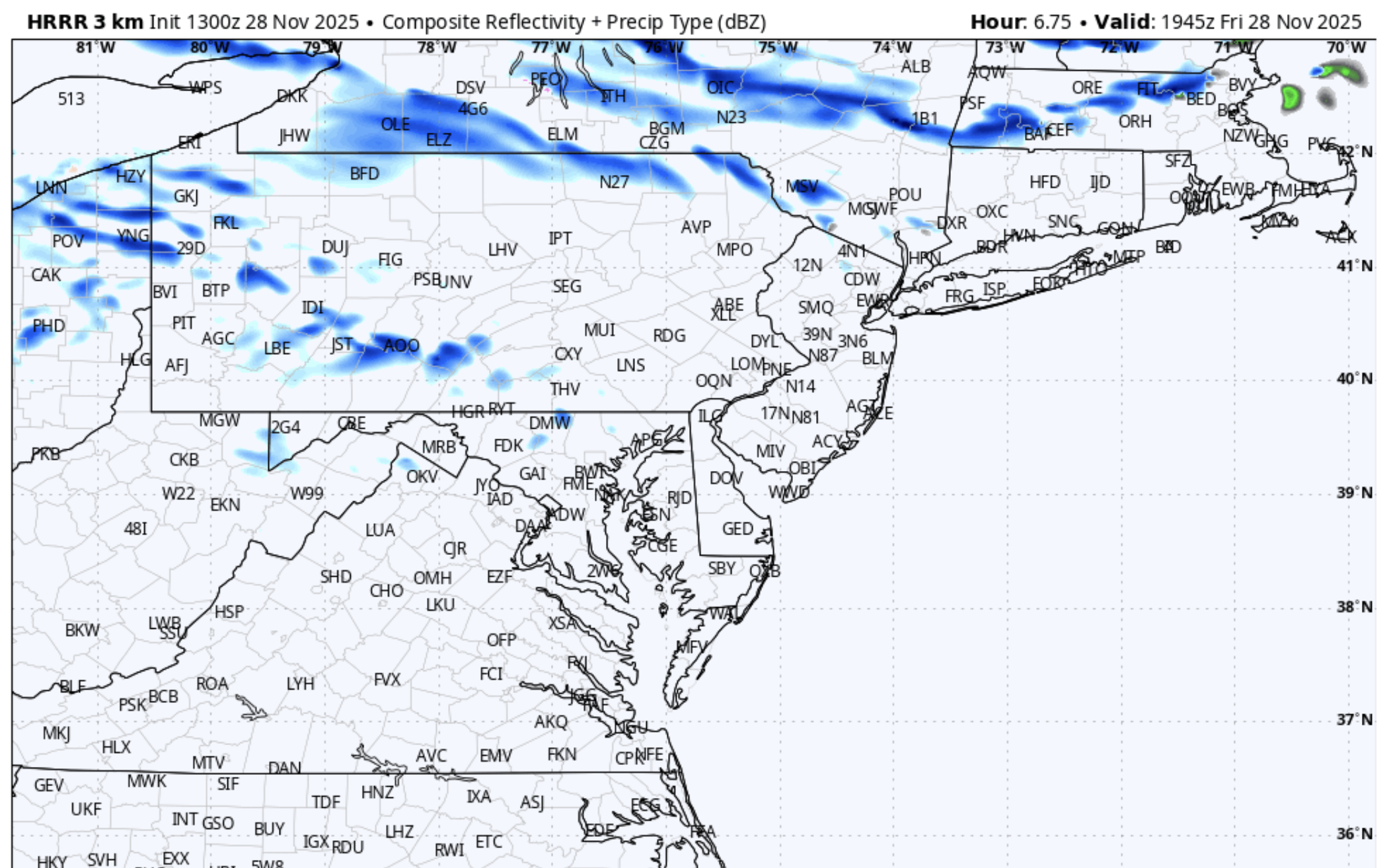
Surprised nobody posted the ICON..... Pretty huge hit well down into CT. Ginxy gonna text Scooter soundings in a few minutes.
-
It is due to climate change. The trade winds unevenly distribute the warmer water to the western pacific. This phenomenon only temporarily bounces back during El Niño years, and doesn’t even fully do this anymore. It’s here to stay.
-

December 2025 Short/Medium Range Forecast Thread
Daniel Boone replied to John1122's topic in Tennessee Valley
The MJO appears to be progressing ideally for our Area through December. However, the AO and NAO are not if guidance were to be right. Of course, those Domains cannot be forecasted with great accuracy, particularly the NAO. The good thing that can mitigate the Effects of the positve Arctic Oscillation Modes is the weak south displaced PV. We saw that in 2015 and a couple recent Years. However, if you want much greater Odds for across the Board Snowstorms you want the Arctic Domain Negative. As witnessed , most notably in 2015, Northern Area's can do well as long as the PV is weak and displaced well South in Canada. -

2025-2026 ENSO
michsnowfreak replied to 40/70 Benchmark's topic in Weather Forecasting and Discussion
I know things are looking decent when we are seeing embedded tweets in French. -
State salt trucks are filled and sitting along rt. 23 in Sussex county. Guess they're expecting some lake effect snow showers this afternoon. They learned their lesson a couple weeks ago. Lol
-
someone tell me why i'm supposed to care about ski resorts
-
Nov 28-30th Post Turkey Day Wintry Potential
michsnowfreak replied to Chicago Storm's topic in Lakes/Ohio Valley
MLI will exceed its 2024-25 total in 2025-26 before December. Thinking 4-6" here. Hoping the dryslot/potential end as rain in sunday morning isn't too bad. -

Nov 28-30th Post Turkey Day Wintry Potential
homedis replied to Chicago Storm's topic in Lakes/Ohio Valley
Interesting signal on the HRRR for some lake enh in far SE WI and Lake County IL. A limiting factor of that would be 1:6-1:8 ratios with the warmer air. -

2025-2026 Fall/Winter Mountain Thread
WeatherHawk replied to Buckethead's topic in Southeastern States
Any updates on Sunday and Tuesday...supposed to start a new job with a steep and shady driveway between Miller's Creek and West Jefferson. 24 here at our place in Jefferson with slight winds and partly cloudy. Hope everyone had a good Thanksgiving! -
C-1" ---> rain. Good for the ski resorts in NY and southern VT though! They need snow.
-
If only we can get the AO and NAO Negative. A weak South displaced PV ala 2015 might still work for Northern Area's. If you want great Odds for SE Snowstorms you want a Negative AO and NAO. Very rarely we see all these line up anymore.
-
I don't think we can determine which factor will eventually cool the WPAC until we can pinpoint what is causing it (as opposed to other areas).
-
maybe we have a shot for some flurries in the afternoon

-
Icon isn't great, but it has creeped further south making it a lot closer than 0z and 6z.
-
 https://weather.cod.edu/satrad/?parms=subregional-New_England-comp_radar-24-1-100-1&checked=map&colorbar=undefined
 -

November 2025 general discussions and probable topic derailings ...
dendrite replied to Typhoon Tip's topic in New England
#neverforget IMG_7041.mov -

2025-2026 ENSO
donsutherland1 replied to 40/70 Benchmark's topic in Weather Forecasting and Discussion
2009-10 was a strong El Niño. 2010-11 was a strong La Niña.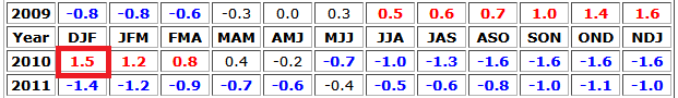
-
I think it would if it wasn’t so marginal in like 100+ millibar layer. I suppose that at the height it could flip to a 33F paste if it’s really really pounding. I just go back in saying bring me those runs from yesterday.
-
Absolutely correct.
-

December 2025 regional war/obs/disco thread
weatherwiz replied to Torch Tiger's topic in New England
The only thing I think Scott tossed was just the snow maps. -

December 2025 regional war/obs/disco thread
Ginx snewx replied to Torch Tiger's topic in New England
I am hoping for heavy rates to wash out minor 850 925 plus .2s -
November 2025 general discussions and probable topic derailings ...
dendrite replied to Typhoon Tip's topic in New England
34° -SN Getting heavier