All Activity
- Past hour
-
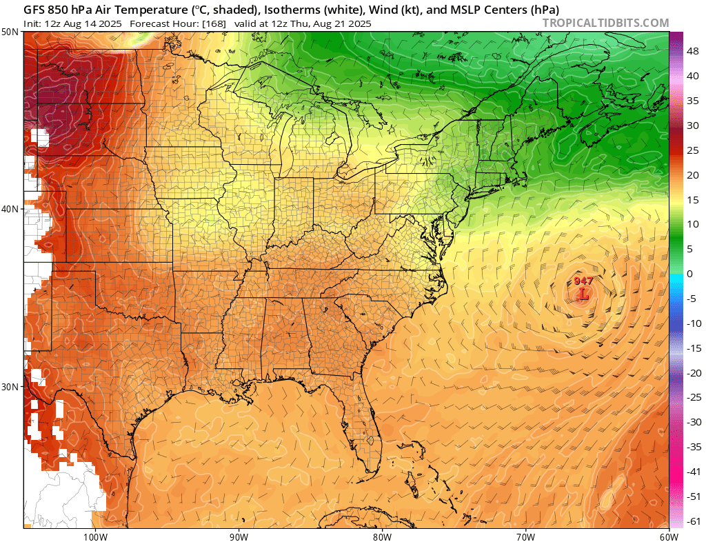
Still squarely a threat to Newfoundland.
-
And they appear to be slow moving
-
Yeah I was at Hydes Field in Baldwin...you could see the rain and lightning... but nothing at the field except for a canceled soccer practice.
-
about 1.5" last night from an overhead cell developing. very close lightning and shook me out of the bed.
-
Hope they all miss the USA.....the fish can afford them but most Americans can't
-
Give me a pattern changing 1" - 3" event the week before Christmas. Then a nice 6" - 10" cold powder event on Christmas Day afternoon that sticks around for a week.
-
Yep
-

2025-2026 ENSO
michsnowfreak replied to 40/70 Benchmark's topic in Weather Forecasting and Discussion
Are you thinking a more front loaded winter? Or rather....a winter where December is one of the bigger hitters rather than Jan/Feb? -

Tropical Storm Erin - NOW AT 50 KTS!
WxWatcher007 replied to BarryStantonGBP's topic in Tropical Headquarters
Just want to continue to highlight that even if Erin isn't a direct threat to the US, it is potentially a threat to Atlantic Canada, specifically Newfoundland, with models showing misses, close approaches, and more direct impacts in various model runs. -
Absolute whiff for the most part in Fallston last night. Almost hilarious how close it was to raining but refused to.
-
We have been leaning more on RONI in recent years reflecting the much warmer global oceanic state. Plus record WPAC warm pool north of the tropics has lead to the record low -PDO enhancing the La Niña background state. So the 2020s have been serving up a new type of La Niña background where it has been more defined by the WPAC warm pool than how cool the Nino 3.4 SSTs have been. It’s also interesting that the weaker RONI winters have been warmer in the multiyear La Ninas groups since 2010. 22-23 featured only a -0.83 weaker RONI and it was the warmest winter of the 3 year group. 16-17 had a weaker positive-0.73 RONI and it was the warmest winter of that two year event. Same for the 11-12 weaker RONI of -0.82 coming in as a warmer winter than 10-11 was. Multiyear La Ninas and DJF RONI https://www.cpc.ncep.noaa.gov/data/indices/RONI.ascii.txt 25-26…….? 24-25….-1.12 22-23…..-0.83 21-22……-1.21 20-21…...-1.17 17-18……..-1.10 16-17……..-0.73 11-12…..-0.82 10-11……-1.42
-
At least for my part of the state, July seems to be our only Tstorm month going back several years.
-
Summer winding down. Large flock of Canadian geese went overhead this morning.
-

2025 Atlantic Hurricane Season
BarryStantonGBP replied to BarryStantonGBP's topic in Tropical Headquarters
-

2025-2026 ENSO
KakashiHatake2000 replied to 40/70 Benchmark's topic in Weather Forecasting and Discussion
https://www.facebook.com/share/p/1ZRAvb2Cut/? climate prediction center on the new enso probabilities -
Look at that ridge pumping on the N/NE flow around Erin… If anything we need to wait for it to get out of the way to allow the return flow back in.
-
@canderson we find ourselves in a familiar spot currently Sent from my SM-G970U1 using Tapatalk
-

Invest 98L - 20/20 - Recon enroute Thursday afternoon
Windspeed replied to BarryStantonGBP's topic in Tropical Headquarters
This may have just enough time to close off prior to landfall. Might even get named. But the real threat here is the potential for significant inland flooding as any surface low moving inland will pull trailing feeder bands. Daytime heating, high CAPE, and an open tap on that bathwater will most likely do its thing for a flooding event this time of year. -
 watch out for surge pricing
 -

Invest 98L - 20/20 - Recon enroute Thursday afternoon
Scott747 replied to BarryStantonGBP's topic in Tropical Headquarters
Recon just left Keesler so it will be a few hours before any upgradable obs were to come in. As mentioned while it looks pretty it's not particularly impressive structurally. But who knows, if they find one barb of a west wind there could be PTC advisories initiated at 4. -

Tropical Storm Erin - NOW AT 50 KTS!
GaWx replied to BarryStantonGBP's topic in Tropical Headquarters
12Z UKMET: similar to last two with recurve at 71.9W: TROPICAL STORM ERIN ANALYSED POSITION : 16.6N 49.1W ATCF IDENTIFIER : AL052025 LEAD CENTRAL MAXIMUM WIND VERIFYING TIME TIME POSITION PRESSURE (MB) SPEED (KNOTS) -------------- ---- -------- ------------- ------------- 1200UTC 14.08.2025 0 16.6N 49.1W 1005 33 0000UTC 15.08.2025 12 17.5N 51.8W 1006 33 1200UTC 15.08.2025 24 18.5N 55.5W 1004 34 0000UTC 16.08.2025 36 19.2N 58.9W 1003 35 1200UTC 16.08.2025 48 19.7N 62.3W 999 36 0000UTC 17.08.2025 60 20.1N 65.0W 996 37 1200UTC 17.08.2025 72 20.8N 67.3W 993 41 0000UTC 18.08.2025 84 22.0N 68.9W 990 44 1200UTC 18.08.2025 96 23.8N 70.3W 988 49 0000UTC 19.08.2025 108 26.0N 71.2W 985 50 1200UTC 19.08.2025 120 28.3N 71.7W 981 52 0000UTC 20.08.2025 132 30.5N 71.9W 979 52 1200UTC 20.08.2025 144 32.6N 71.0W 976 59 0000UTC 21.08.2025 156 34.6N 68.7W 970 66 1200UTC 21.08.2025 168 36.4N 65.0W 969 63 -
Who cares? Add 2 degrees every day to their temps during the leaf season if it makes you hard.
-
I wonder if this correlation changes at all with the strength of the ENSO event. It's going to be a fairly weak event in terms of ENSO, so perhaps the correlation won't be as reliable. The weakest example you showed for 16-17 didn't match the expected pattern. I guess it may depend on what is driving it. I suppose the -PDO implies the atmosphere thinks its la nina regardless of ENSO, at least to some degree.
-

2025-2026 ENSO
40/70 Benchmark replied to 40/70 Benchmark's topic in Weather Forecasting and Discussion
I think it's a no-brainer to take the under on last year....odds are two La Nina seasons with a deeply -PDO will feature an extremely +PNA.