All Activity
- Past hour
-

2025 Short Range Severe Weather Discussion
CheeselandSkies replied to Chicago Storm's topic in Lakes/Ohio Valley
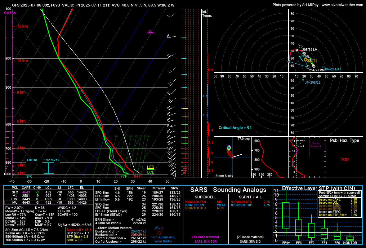
GFS has been somewhat interesting for Friday afternoon/evening around northern IL, although it generates so much precip its hard to get a good handle on what the warm sector might actually look like. Near IL/WI stateline, more hodograph curvature, less instability: Further southeast, near SW burbs. Nice fat CAPE and plenty of 0-3KM CAPE: Those hodographs coupled with the high PWATs suggest HP modes to me, however especially on the second one it looks like the SR inflow might be small enough you can get smaller cells that aren't as rainy as you'd otherwise expect. We've pulled that off around here before on days like 8/9/21.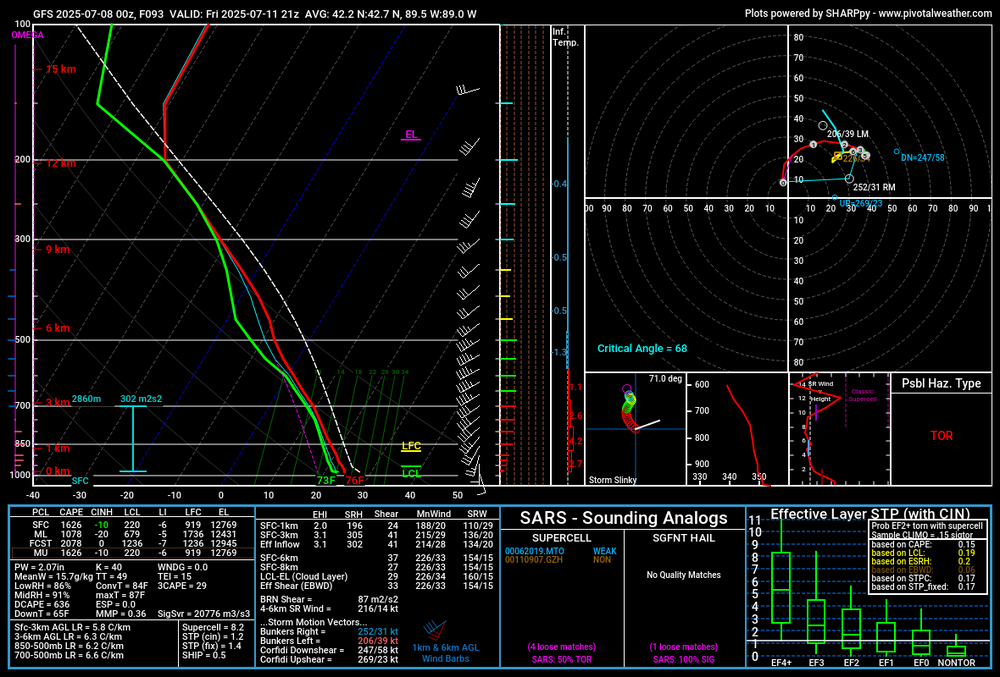

-
Midnight and the heat index is 83.
- Today
-
-
0.65 from a thunderstorm this afternoon ..... Easily the best tstorm rainfall season I've experienced in some years down here... Thunderstorm rain in NW Waynesboro just isn't very productive, it didnt take long after leaving western Albemarle in 2007 to realize that there was a significant decrease in convective rainfall here...
-

July 2025 Obs/Disco ... possible historic month for heat
TauntonBlizzard2013 replied to Typhoon Tip's topic in New England
We’ll see. I’m not holding out much hope. It’s looked kind of crappy for a while -

July 2025 Obs/Disco ... possible historic month for heat
dendrite replied to Typhoon Tip's topic in New England
76.7° and pushing midnight. -

July 2025 Discussion-OBS - seasonable summer variability
doncat replied to wdrag's topic in New York City Metro
Missed the rain again with just 0.02"...high of ,88° with the se wind. -

July 2025 Obs/Disco ... possible historic month for heat
DavisStraight replied to Typhoon Tip's topic in New England
I'm 75/71 it is a nice night, cat loves it. -
83/78 at DCA. brutal.
-

July 2025 Obs/Disco ... possible historic month for heat
Torch Tiger replied to Typhoon Tip's topic in New England
"awful" as some say -
Since the daily index hit -2.00 nearly 3 weeks ago I've been waiting for a bounce up that, thus far, refuses to commence. It OBVIOUSLY will bounce back up a bit sooner rather than later but this has been impressive to track.
-
There were numerous crazy high 24 hour rainfall amounts in C NC! It’s been over 25 years (almost back to when World Wide Web came into existence) since widespread very heavy 24 hour rainfall amounts like these occurred in this region: Insanity: PUBLIC INFORMATION STATEMENT NATIONAL WEATHER SERVICE RALEIGH NC 1134 AM EDT MON JUL 7 2025 ...24 HOUR PRECIPITATION REPORTS OVER 7 INCHES ENDING AT 8AM FROM THE REMNANTS OF TROPICAL STORM CHANTAL... LOCATION AMOUNT TIME/DATE PROVIDER ..NORTH CAROLINA ..ALAMANCE COUNTY MEBANE 3.0 SSW 9.73 IN 0700 AM 07/07 COCORAHS BURLINGTON 3.9 NNW 8.01 IN 0700 AM 07/07 COCORAHS 0.5 SW HAW RIVER 7.79 IN 1045 AM 07/07 COOP 1.3 SE GRAHAM 7.62 IN 0705 AM 07/07 COOP ..CHATHAM COUNTY 2.4 N MONCURE 11.92 IN 1045 AM 07/07 COOP PITTSBORO 8.8 NNE 11.53 IN 0700 AM 07/07 COCORAHS PITTSBORO 5.0 NE 10.37 IN 0700 AM 07/07 COCORAHS PITTSBORO 3.3 NNW 10.35 IN 0849 AM 07/07 COCORAHS PITTSBORO 10.15 IN 1055 AM 07/07 CWOP CHAPEL HILL 5.9 SW 10.05 IN 0700 AM 07/07 COCORAHS PITTSBORO 5.4 WSW 9.44 IN 0700 AM 07/07 COCORAHS CHAPEL HILL 8.6 SSW 9.25 IN 0700 AM 07/07 COCORAHS PITTSBORO 0.8 NNW 9.12 IN 0700 AM 07/07 COCORAHS SILER CITY 6.6 ENE 9.10 IN 0640 AM 07/07 COCORAHS SILER CITY 8.1 ENE 8.14 IN 0800 AM 07/07 COCORAHS GOLDSTON 3.8 N 7.94 IN 0700 AM 07/07 COCORAHS SILER CITY 7.2 NE 7.54 IN 0800 AM 07/07 COCORAHS SILER CITY 7.23 IN 1055 AM 07/07 CWOP SILER CITY 7.10 IN 0700 AM 07/07 COCORAHS ..DURHAM COUNTY DURHAM 4.6 WNW 8.46 IN 0700 AM 07/07 COCORAHS DURHAM 5.8 NW 8.23 IN 0700 AM 07/07 COCORAHS HILLSBOROUGH 7.26 IN 1100 AM 07/07 CWOP DURHAM 5.2 NW 7.19 IN 0615 AM 07/07 COCORAHS ..MOORE COUNTY 2 WSW WHISPERING PINES 7.45 IN 0800 AM 07/07 COCORAHS WHISPERING PINES 1.0 SW 7.20 IN 0800 AM 07/07 COCORAHS ..ORANGE COUNTY HILLSBOROUGH 8.4 NNE 10.49 IN 0840 AM 07/07 COCORAHS HILLSBOROUGH 7.4 NW 10.43 IN 0700 AM 07/07 COCORAHS CHAPEL HILL 4.5 WSW 10.22 IN 0700 AM 07/07 COCORAHS HILLSBOROUGH 5.6 NNW 9.96 IN 0700 AM 07/07 COCORAHS CARRBORO 0.7 NNE 9.82 IN 0800 AM 07/07 COCORAHS DURHAM 6.7 WNW 9.80 IN 0800 AM 07/07 COCORAHS CHAPEL HILL 4.7 SW 9.57 IN 0700 AM 07/07 COCORAHS DUKE FOREST DURHAM 11 W 9.36 IN 1100 AM 07/07 HADS DURHAM 9.28 IN 1045 AM 07/07 CWOP CHAPEL HILL 2.0 NNE 9.20 IN 0700 AM 07/07 COCORAHS EFLAND 4.0 NNW 9.10 IN 0700 AM 07/07 COCORAHS HILLSBOROUGH 0.6 NNW 8.89 IN 0800 AM 07/07 COCORAHS EFLAND 8.75 IN 1055 AM 07/07 CWOP CHAPEL HILL 4.3 WSW 8.70 IN 0730 AM 07/07 COCORAHS HILLSBOROUGH 1.8 S 8.41 IN 0800 AM 07/07 COCORAHS CARRBORO 0.8 SE 8.36 IN 0700 AM 07/07 COCORAHS HILLSBOROUGH 1.5 NE 8.36 IN 0700 AM 07/07 COCORAHS CARRBORO 0.6 NNE 8.32 IN 0602 AM 07/07 COCORAHS 0.5 SE CARRBORO 8.00 IN 0700 AM 07/07 COOP CHAPEL HILL 8.2 W 7.92 IN 0700 AM 07/07 COCORAHS CHAPEL HILL 7.88 IN 1229 AM 07/07 CWOP DUKE FOREST MET STA NR CHAPE 7.82 IN 1016 AM 07/07 RAWS CHAPEL HILL 7.2 WSW 7.76 IN 0800 AM 07/07 COCORAHS CHAPEL HILL 4.0 WNW 7.73 IN 0700 AM 07/07 COCORAHS CHAPEL HILL 9.4 W 7.69 IN 0730 AM 07/07 COCORAHS HURDLE MILLS 7.58 IN 1045 AM 07/07 CWOP ROUGEMONT 4.7 SW 7.54 IN 0700 AM 07/07 COCORAHS CHAPEL HILL 11.4 W 7.53 IN 0715 AM 07/07 COCORAHS HILLSBOROUGH 4.0 SSW 7.48 IN 0600 AM 07/07 COCORAHS 1 SE CHAPEL HILL 7.33 IN 0700 AM 07/07 COCORAHS HILLSBOROUGH 2.8 SSW 7.27 IN 0709 AM 07/07 COCORAHS 2 NNE CHAPEL HILL 7.21 IN 1105 AM 07/07 AWS ..PERSON COUNTY HURDLE MILLS 5.2 NNW 9.15 IN 0800 AM 07/07 COCORAHS
-

July 2025 Obs/Disco ... possible historic month for heat
metagraphica replied to Typhoon Tip's topic in New England
76/74. Downright tropical. -
July 2025 Obs/Disco ... possible historic month for heat
dendrite replied to Typhoon Tip's topic in New England
When was the last time you missed one? 1980s? -
Cell that moved through Lebanon County just now dropped a quick .67” in 30 minutes. .69” on the day and now 2.00” on the month so far already .
-

E PA/NJ/DE Summer 2025 Obs/Discussion
LVLion77 replied to Hurricane Agnes's topic in Philadelphia Region
It is shocking not to see anything here today. Definitely the soupiest day of the summer! There is a line coming through central PA, but I am not sure it survives the trip east. . -
I am now. Thanks.
-
Had a trace of rain tonight
-
Both the 0Z HRRR and 3K showing a strong signal for storms moving west to east tomorrow afternoon. 3K perhaps showing signs of a bow exiting east across the bay onto the eastern shore.
-
exactly
-

July 2025 Obs/Disco ... possible historic month for heat
Snowedin replied to Typhoon Tip's topic in New England
You guys up north are a magnet for moisture in the summer, almost the same way we have our predictable moisture train much of the winter and early spring. I have a hunch tomorrow we’ll get our turn though. The air has that electric feel to it like something is about to pop. -

July 2025 Obs/Disco ... possible historic month for heat
powderfreak replied to Typhoon Tip's topic in New England
The joy of hit and miss thunderstorms. We are right around 1" of rain, stratus inner tube full but nothing in the outer ring. Looks like MVL ASOS went offline two hours ago after 1.49" and I know they had another round after that. Saw a bunch of 1.75-2.25" stations over on the west side of Mansfield in Jericho and Underhill. -
Tropical storms being retired is exceptionally rare, but this could qualify given the obscenely destructive nature of its remnants—though it being a post tropical low may hurt its case. Allison 2001 and Erika 2015 are the only two retirements.
-
Excessive Rainfall DiscussionNWS Weather Prediction Center College Park MD731 PM EDT Mon Jul 7 2025Day 2Valid 12Z Tue Jul 08 2025 - 12Z Wed Jul 09 2025...THERE IS A SLIGHT RISK OF EXCESSIVE RAINFALL FOR THE EASTERNMID-ATLANTIC STATES AND SOUTHERN NEW ENGLAND, AS WELL AS PARTS OFTHE SOUTHERN PLAINS......Mid-Atlantic and Northeast...Post-tropical cyclone Chantal will be exiting east of Cape Cod tostart the period as it continues to get caught up in increasingsouthwesterlies downstream of a trough approaching from the GreatLakes. This trough will continue to translate eastward through theday, but will be slow to advect due to downstream Bermuda-typeridging. Between these two features, SW flow will remain prevalentover the area, with 850-500mb winds being nearly unidirectionalfrom the W/SW at 15-20 kts. This will result in a continuedextremely moist environment with PWs likely eclipsing 2" fromeastern VA through southern New England Tuesday afternoon,coincident with a plume of SBCAPE exceeding 2000 J/kg.Into these impressive thermodynamics, a shortwave embedded withinthe mean flow will traverse northeast ahead of a cold front andalong a surface trough, providing additional ascent atop thealready impressive convergence on these boundaries. This suggestsshowers and thunderstorms will become widespread, which isadditionally supported by high-res CAM simulated reflectivity.Storms that develop will move very slowly, and Corfidi vectorscollapsed to just around 5 kts will support backbuilding andtraining echoes along the surface trough and front. With warm clouddepths potentially eclipsing 14,000 ft, this will support efficientwarm-rain processes and rain rates above 2"/hr at times. Wheretraining occurs, this could result in total rainfall in excess of3", with instances of flash flooding possible across much of theI-95 corridor from Richmond, VA to Portland, ME, and a slight riskhas been added for this area.
-

July 2025 Discussion-OBS - seasonable summer variability
LongBeachSurfFreak replied to wdrag's topic in New York City Metro
I would have a second Manhattan project but for fusion. Problem solved.