All Activity
- Past hour
-
There’s no more trees left in the arrowhead of Minny
-

1/24-1/25 Major Winter Storm - S. IL, IN, and OH
michsnowfreak replied to A-L-E-K's topic in Lakes/Ohio Valley
Nov- 2 Dec- 12 Jan- 10 Feb- 13 Mar- 4 Apr- 1 -
(002).thumb.png.6e3d9d46bca5fe41aab7a74871dd8af8.png)
January 25-26 Winter Storm Potential
ChescoWx replied to Ralph Wiggum's topic in Philadelphia Region
Would imaging being a professional you are a wee bit busy!! good luck!! -
This thing trends 15 miles south Chattanooga is in a world of hurt…. .
-

Richmond Metro/Hampton Roads Area Discussion
RVASnowLover replied to RIC Airport's topic in Mid Atlantic
It's really close. Models are struggling. -
What a time to be alive. I can’t wait for this to spread on social media and end up on the news.
-
Meaning not occasional gusts. I think the idea is the gusts have to be occurring often and not just here and there.
-

Texas 2026 Discussion/Observations
canderson replied to Stx_Thunder's topic in Central/Western States
I tend to think you guys do get more sleet than zr. I’ll go on a limb and say .2-.3” zr and 3” sleet for Longview -
Hey Paul, I don't have that list for you readily available, sorry! The NOAA climate sites that I use for this allow you to parse the data by day, but not necessarily by "storm". So I could find this for you through some manual interpretation and adding up snow from known storms by each day, but I can't do it right now haha.
-

January 25/26 Jimbo Back Surgery Storm
NorthHillsWx replied to Jimbo!'s topic in Southeastern States
Looking closer at the 12z CAMs even though a lot of moisture was going north, you can see the showers that develop in the dry slot and I think that’s what some here have been picking up on- if you’re in the wedge even though you might get the dry slot it likely doesn’t stop precipitating. Happens all the time with warm season wedges, supposed to be 70 but stuck at 50 and drizzle, light rain. Not convinced the moisture goes north of us but if it does it doesn’t mean it stops the precip -

Jan 24-26 Weekend Snow and Sleetfest Model Thread Part Tres
yoda replied to H2O's topic in Mid Atlantic
URGENT - WINTER WEATHER MESSAGE National Weather Service Wakefield VA 216 PM EST Fri Jan 23 2026 MDZ021-VAZ048-060>062-064-068-069-075-076-082-083-090-509>522-240330- /O.UPG.KAKQ.WS.A.0001.260124T1800Z-260126T1800Z/ /O.NEW.KAKQ.WS.W.0001.260124T1800Z-260127T0000Z/ Dorchester-Fluvanna-Prince Edward-Cumberland-Goochland-Caroline- Amelia-Powhatan-Westmoreland-Richmond-Charles City-New Kent-James City-Western Louisa-Eastern Louisa-Western Hanover-Eastern Hanover-Western Chesterfield-Eastern Chesterfield (Including Col. Heights)-Western Henrico (Including the City of Richmond)-Eastern Henrico-Western King William-Eastern King William-Western King and Queen-Eastern King and Queen-Western Essex-Eastern Essex- 216 PM EST Fri Jan 23 2026 ...WINTER STORM WARNING IN EFFECT FROM 1 PM SATURDAY TO 7 PM EST MONDAY... * WHAT...Heavy mixed precipitation expected. Snow and sleet will accumulate Saturday evening and overnight and then change to freezing rain during the day Sunday. Total snow and sleet accumulations Saturday night into Sunday morning between 4 and 9 inches and ice accumulations up to three quarters of an inch Sunday into Sunday night. * WHERE...Portions of southeast Maryland and central, east central, north central, and southeast Virginia. * WHEN...From 1 PM Saturday to 7 PM EST Monday. * IMPACTS...Devastating impacts are expected including widespread power outages and tree damage due to the ice. Travel could quickly become nearly impossible. Due to the increasing wind on Monday, additional tree damage and power outages are possible. People should prepare for power outages to potentially last for several days along with extreme cold. -

January 2026 regional war/obs/disco thread
George001 replied to Baroclinic Zone's topic in New England
The A in Miller A = asshole The B in Miller B = burial -
January 25-26 Winter Storm Potential
ChescoWx replied to Ralph Wiggum's topic in Philadelphia Region
12z Euro still showing ZR where their is likely sleet but it looks to have slightly bumped up totals across NW Chesco from 6z but basically pretty steady! -

“Cory’s in LA! Let’s MECS!” Jan. 24-26 Disco
WxWatcher007 replied to TheSnowman's topic in New England
Plenty of bark on the trees here in the Adirondacks -

Possible Record Breaking Cold + Snow Sunday 1/25 - Tuesday 1/27
DreamBig replied to TriPol's topic in New York City Metro
If you're a Christopher Walken fan, let's agree on somewhere between three and four hundred inches. -

January 25-26 Winter Storm Potential
Birds~69 replied to Ralph Wiggum's topic in Philadelphia Region
Define frequent? Seems vague... *I understand you did not make the definition of a blizzard -
1st gut call in my area 10-11" snow and 1" sleet/graupel High end SECS possibly hit the MECS mark
-

Richmond Metro/Hampton Roads Area Discussion
jlewis1111 replied to RIC Airport's topic in Mid Atlantic
Lonnnnggg Event -
Jan 24-26 Weekend Snow and Sleetfest Model Thread Part Tres
yoda replied to H2O's topic in Mid Atlantic
Also here now https://www.fox5dc.com/weather/gov-wes-moore-declares-state-emergency-maryland-due-winter-storm -

E PA/NJ/DE Winter 2025-26 Obs/Discussion
RedSky replied to LVblizzard's topic in Philadelphia Region
5" snow depth at the level -

Jan 24-26 Weekend Snow and Sleetfest Model Thread Part Tres
Scraff replied to H2O's topic in Mid Atlantic
After being in Alaska last summer, my wife was wondering what life would be like in Alaska during winter. Welp. Next few weeks, we about to find out! Though no negative temps I think, but still… -
January 25-26 Winter Storm Potential
Birds~69 replied to Ralph Wiggum's topic in Philadelphia Region
Chains actually work pretty well. Never went through the hassle of studded/spiked tires...not sure if they are still legal in certain states? Probably mess up the road. -
January 25-26 Winter Storm Potential
ChescoWx replied to Ralph Wiggum's topic in Philadelphia Region
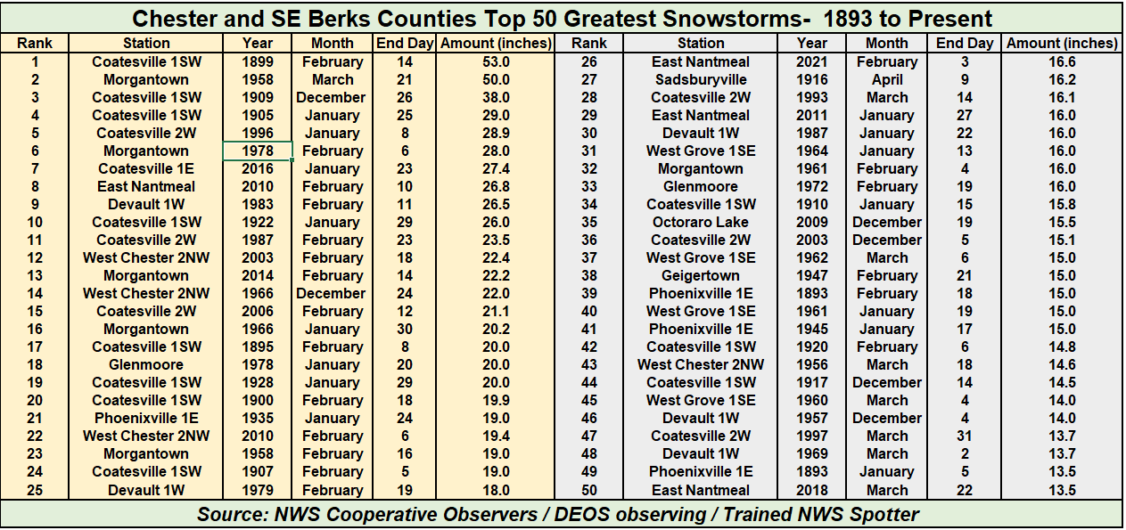
Hey Newman! Thanks - do you by chance have the top 25 total snowstorms for ABE? I need to go back and do that for Chester County stations. Below though are the Top 50 snowstorms in Chester County history since 1894. We will likely not break into the top 50 with this one!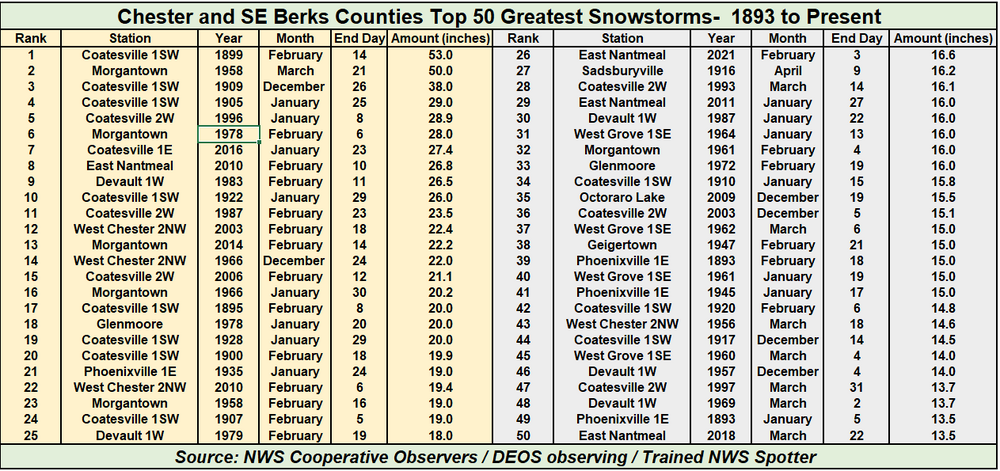
-
“Cory’s in LA! Let’s MECS!” Jan. 24-26 Disco
J Paul Gordon replied to TheSnowman's topic in New England
Any ideas about start and duration in North and South Central Mass on Sunday-Monday? Also, will snow become intense quickly? Traveling to Southbridge from Clinton early am and back early pm. -
Central PA Winter 25/26 Discussion and Obs
canderson replied to MAG5035's topic in Upstate New York/Pennsylvania
Link please