All Activity
- Past hour
-

Central PA Summer 2026 Discussion/Obs Thread
Voyager replied to Voyager's topic in Upstate New York/Pennsylvania
83/71 at 10:30am. She sure is muggy today. We've got a good deal of sun here currently, so good fuel for storms later I suppose. -

E PA/NJ/DE Summer 2026 Obs/Discussion
The Iceman replied to PhiEaglesfan712's topic in Philadelphia Region
30% wind probs today and tomorrow for most of the area... decent soaking last night for my area, picked up a quick .40". SPC day 1 ...Mid-Atlantic ad central Appalachians... Forcing for ascent from multiple shortwave disturbances across the northeast and dewpoints in the 60s to 70s F will support development of widely scattered thunderstorms by afternoon across the Mid-Atlantic into the central Appalachians. Though vertical shear will be generally weak, moderate to strong instability will be in place will support stronger updrafts capable of damaging winds. It is likely that several clusters will emerge with potential for organizing along cold pools and more focused corridors of damaging wind potential. -

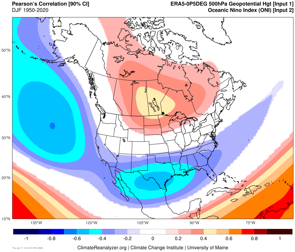
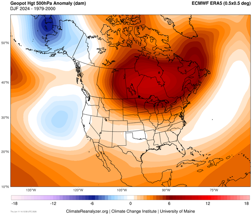
2026-2027 Super El Nino
bluewave replied to Stormchaserchuck1's topic in Weather Forecasting and Discussion
It appears that the -PDO through the warm pool east of Japan and active MJO 4-7 caused the Aleutian low to split into two weaker low pressure centers. Probably why the -1.5 RONI was so far behind the ONI. But for the Great Lakes into Northeast the El Nino ridge was even stronger than would be expected with a +2.1 ONI. Could also be the general expansion of mid-latitude ridges leading to the lack of a strong trough response in the Mid-Atlantic and Southeast.
-

Junorch obs and discussion 2026
TauntonBlizzard2013 replied to Damage In Tolland's topic in New England
Bone dry here overall. Hate to see it -
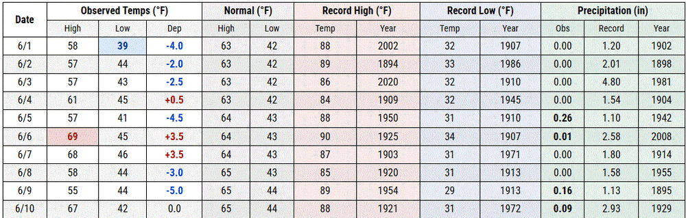
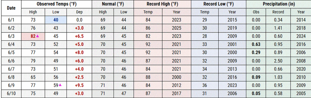
So absurd, most places have seen mean high temps in/near top 10 warmest on record for first decade of June. Philadelphia - 5th warmest; Providence, RI - 3rd warmest; Newark, NJ - 9th warmest. But Central Park is at 36th warmest. Closest analog is Worcester, MA at 23rd warmest, but their station thread includes decades from a station hundreds of feet lower in elevation.
-
Wow, that's a mean lookin Dercho bitch about to unleash fury on Iowa City
-
Junorch obs and discussion 2026
TauntonBlizzard2013 replied to Damage In Tolland's topic in New England
Yeah. I keep looking for signs of real sustained heat in the long range and it’s not really there -
Morning low of 65 here, first 60+ minima of the season. First TD near/at 70 as well.
-
sort of... As Brian was intimating, there was conjecture/interpretation for a cooler first half of June back whence. I personally give that the benefit of the doubt ( although privately ... there are those that falter implementation of any 'cold bullshit filter' so they may have a bias contribution that it's totally going so snow on July 20th ... weeee Excluding that contribution though ), but in doing so, was adding the notion: it seems that verifying warmer than guidance is overwhelmingly the observation compared to colder than guidance, regardless of future patterns being offered. I mean it may have even verified a cooler "looking" pattern, but for whatever reason ( probably CC, let's get real - ) your likely to flop on the warm side.
-
84/77 soupy n steamy
-

Junorch obs and discussion 2026
TheClimateChanger replied to Damage In Tolland's topic in New England
It has certainly been a solid first decade of June for summer weather lovers in the northeast IMHO. Many places are in the top 10 for mean maximum temperature - including Caribou, ME (5th), Concord, NH (4th), Providence, RI (T-3rd), and numerous other sites around the region. Would expect these to trend even higher. Was it supposed to be cold or something? -
How is it already 85° out? I think today will be day 15 of no rain too, so nothing to cool it off.
-
Overnight crapvection shunted the real instability south as usual. Maybe 1-94 but I’m hosed up here. Michigan.
-
Nothing but sunny skies here in IKK since daybreak, thought it might be an overcast start to the day
-
Two notable storms in Feb 1969. The late month "100-hour" storm was a New England event; we had 4" of mush at our NNJ home. The storm of 9-10 was the "Mayor Lindsey" snow. The NYC forecast had been heavy cold rain, but the 15.3" of heavy wet snow that paralyzed the city as the sanitation crews (plows on garbage trucks) were not alerted. The head of the sanitation union said of Lindsey, "He played it by ear but was stone deaf!" Our scout troop was at Allamuchy Scout Camp in NW NJ that weekend, but my 1962 Beetle had no problems even though there was 8-9" new by the time we got home that Sunday.
-
I believe we will see some changes regarding expectations for today. Let the HRRR catch up to reality over the next few runs, and we’ll likely see a clearer and different picture painted.
-
Big difference between shoreline wx, and inland wx here at Two Harbors. TH Co-op 7 am readings (on the shore) TH 7NW Co-op 7 pm readings (inland)
-
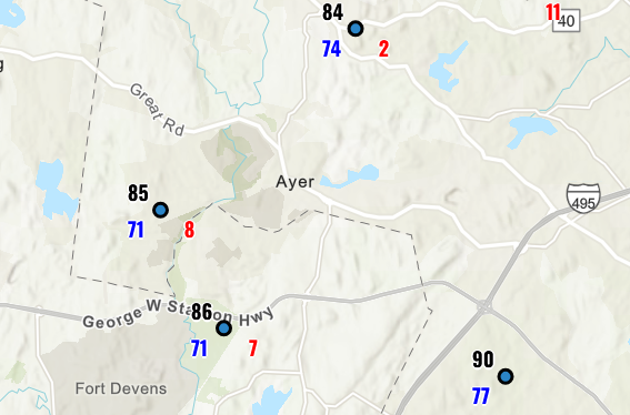
I can tell you these 'feel' correct... Approaching 10, and these have another update coming... so, 10 after 10 pushes this deep into stifling and prooobaly more warning level heat than just Advisory from about 1pm thru 5pm... I don't know what the time requirements are on the headlines so not criticizing there, per se... but if we tap 94 ..95/72, that's a damn sizzling HI. By the way, this region appears to be weirdly 2-3 F hotter than everywhere else at this particular time.
-

2026 Atlantic Hurricane Season
jconsor replied to Stormchaserchuck1's topic in Tropical Headquarters
Seeing some potential interesting tropical mischief in the GOM next week. A stalled frontal boundary providing vorticity, remnant energy from the system entering the BOC this weekend dragging up lots of tropical moisture, and indications of a pocket of lower shear and diffluence between central US trough and a persistent GOM ridge: https://x.com/yconsor/status/2065067111521652967 -

2026-2027 Super El Nino
40/70 Benchmark replied to Stormchaserchuck1's topic in Weather Forecasting and Discussion
Lagging RONI was likely a reflection of the more meager Aleutian low, as we have discussed...but the huge ridge over the northeast was all ONI. -
The drought stuff is out of control. There’s so many Mets out there that just blindly take Logan‘s record and run with it and make it look like that’s everyone across southern New England. It’s pretty obvious the two big snowstorms caused issues with catching the right amount of LEQ because all the other co-ops around Logan have a lot more from those two storms in terms of liquid equivalent than the ASOS. It’s not hard to dig a little deeper and see that. Yes it’s obviously been dry but not the record amount that’s being touted. People just diminish the science so much lately.
-
M0.82" yesterday. Absolutely poured for an hour. 2" PWATs baby.
-
Latest GFS doesn't show a whole lot of promise. the only "meaningful" rain fall set up looks to be next Tuesday and Wednesday. Sure the overall isolated/scattered afternoon storms seems like a good bet just about everyday. but only one real chance of an area wide rain through basically the end of the month.
-
June 11 2011: Severe thunderstorms bring extremely strong winds to central Minnesota. An unofficial wind gust of 119 mph is reported at a seed farm 1 mile northwest of Atwater. A storm chaser's car was battered when he got too close to the storm. Most of the windows in the car were broken. 1996: 5.91 inches of rain fall at Mankato. Mudslides close roads, including Hwy. 169, and push a trailer home 20 feet down a hill. 1922: A hailstorm at Maple Plain causes extensive damage to crops. For Thursday, June 11, 2026 1842 - A late season snowstorm struck New England. Snow fell during the morning and early afternoon, accumulating to a depth of ten to twelve inches at Irasburg VT. Berlin NH was blanketed with eleven inches of snow during the day. Snow whitened the higher peaks of the Appalachians as far south as Maryland. (David Ludlum) 1877 - The temperature at Los Angeles, CA, reached 112 degrees during a heatwave. It would have been the all-time record for Los Angeles but official records did not begin until twenty days later. (The Weather Channel) 1972 - Heavy showers brought 1.64 inches of rain to Phoenix AZ, a record for the month of June. (The Weather Channel) 1987 - South Texas endured another day of torrential rains. Up to twelve inches of rain drenched Harris County, and nearly ten inches soaked Luce Bayou, mainly during the afternoon hours. Thunderstorm rains left seven feet of water over Highway 189 in northern Val Verde County. Flooding caused nine million dollars damage in Real County. A thunderstorm at Perryton, TX, produced golf ball size hail and 70 mph winds, and spawned a tornado which struck a mobile killing one person and injuring the other four occupants. (The National Weather Summary) (Storm Data) 1988 - Thirty cities in the central and eastern U.S. reported record low temperatures for the date, including El Dorado, AR, with a reading of 48 degrees. Canaan Valley WV and Thomas WV dipped to 30 degrees. Flagstaff AZ was the cold spot in the nation with a low of 30 degrees. Coolidge, just 180 miles away, was the hot spot in the nation with an afternoon high of 105 degrees. (The National Weather Summary) 1989 - Thunderstorms produced severe weather in the south central and southeastern U.S. during the day and night. Thunderstorms spawned eleven tornadoes, including one which tore the roof off a restaurant at Bee Branch, AR, injuring six persons. The tornado tossed one car into the restaurant, and another car over it. Temperatures soared into the 90s across much of Florida. Lakeland reported a record high of 99 degrees for the second day in a row. (The National Weather Summary) (Storm Data) Observances: 11 Thu National Corn On The Cob Day 11 Thu Say Hi Day 11 Thu Yarn Bombing Day 11 Thu Kamehameha Day
-
It’s been 17 days since the last measurable rain here. The number of 2+ week rainless stretches dating back to last year insane, I wish I tracked that