All Activity
- Past hour
-
Not surprised. It's all went from exhilarating to sickening.
-
The NAM is identical to the euro in the useful part of its range, which matters most, because the interaction with the Baja blast and the trough over Montana dictates everything downstream.
-
Could this be as big or bigger than the 1993 or 1996 storms? They were awesome!
-
the part i forgot: The trajectory of the WAA runs heavily north of the city, forming a finger-like stream of precip that stays north while the city stays dry for 12 hours
-

Possible Record Breaking Cold + Snow Sunday 1/25 - Tuesday 1/27
SnoSki14 replied to TriPol's topic in New York City Metro
Yeah but one that could maximize over our region and dump 2-4/per hour rates for a few hours and us close to a foot of snow. -

January 2026 regional war/obs/disco thread
ORH_wxman replied to Baroclinic Zone's topic in New England
Yeah we could slam 10-15” alone from the overrunning if you push that north a bit more. But we’d def need a CCB type sig to get going if you want KU type totals over 20”. -

Possible Record Breaking Cold + Snow Sunday 1/25 - Tuesday 1/27
Franklin0529 replied to TriPol's topic in New York City Metro
Yea nobody would be upset with a foot that ends with a little sleet -

January 2026 regional war/obs/disco thread
ineedsnow replied to Baroclinic Zone's topic in New England
We had a few houses that would give me and my friends 20 bucks to shovel in the early 90s.. it was great! -

2025-2026 Fall/Winter Mountain Thread
Tyler Penland replied to Buckethead's topic in Southeastern States
To be fair, the long range NAM is usually pretty strange. -

Possible Record Breaking Cold + Snow Sunday 1/25 - Tuesday 1/27
Brian5671 replied to TriPol's topic in New York City Metro
You'll still see a nasty swath of ice on the southern flank of the storm regardless of where it ends up. -

January 2026 regional war/obs/disco thread
The 4 Seasons replied to Baroclinic Zone's topic in New England
Feb 1-3 2021 was pretty cold. It was in the mid teens to low 20s for highs right before the storm with lows in the single digits to around zero. Jan 28,29,30 was 15F, 18F, and 21F at ORH for a high. Not this cold, but still pretty damn cold. I remember it being frigid before that storm. -
For me, yes. Tired of sickness in this house.
-
January 2026 regional war/obs/disco thread
ORH_wxman replied to Baroclinic Zone's topic in New England
My mom would sometimes bribe the street plow guy in ORH with a $10 bill to get our driveway in storms circa early/mid 1990s. In bigger ones you might have to go with a 20. Before we got a snowblower at my current place, we got a guy to get our driveway for 40 bucks in March 2018…that was a pretty good price even then. That was pre-inflation though. -
Yes! The dgex is back!
-
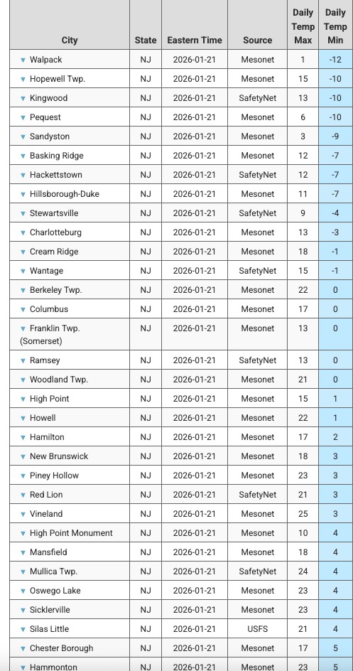
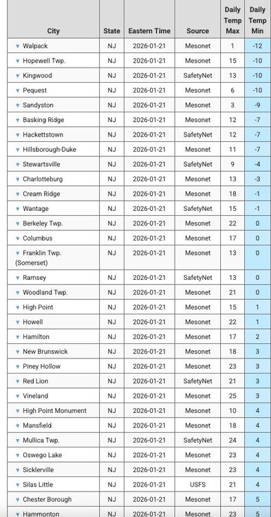
Got down to 6 here on top of the hill, my location is the highest point in the area. Other readings at lower elevations around me were in the +1 to +2 range. Saw a +5 and +7 but not sure of their elevation. NJ coldest mins:
-
Watch for that going forward. Keep that fucker from sliding east to maine
-
Possible Record Breaking Cold + Snow Sunday 1/25 - Tuesday 1/27
Brian5671 replied to TriPol's topic in New York City Metro
A glorified SWFE -

Possible Record Breaking Cold + Snow Sunday 1/25 - Tuesday 1/27
forkyfork replied to TriPol's topic in New York City Metro
that's what i'm thinking -
Not crazy about the trends BUT this is the NAM, and it is out of it's range to boot. Let's at least wait until it is in its range. Interested in seeing what the Euro and GFS show later today.
-
That's a Scenario that looked plausable to me after seeing the UK last night but didn't want to Debbie down anymore. A strong ejecting system with a northern vort pull and a weakness between hp Area's can allow for a conduit to open as we know. Webb began fearung that yesterday Afternoon. I think Bamwx was just going by Climo and maybe desire in his earlier North trend depiction. Hopefully that Northern Plains HP strengthens and that Northern vort doesn't pull the Baja LP. That's really our hope.
-
If that HP to the north of NY can stay there as long as possible it will balance out the amped look
-

MO/KS/AR/OK 2025-2026 Winter Discussion
The Waterboy replied to stormdragonwx's topic in Central/Western States
We’re starting to cut it real close from OKC to Tulsa to Bentonville. That run gives me 11” but 50 miles south is 6” of sleet. Can’t recall ever seeing that much sleet modeled. JoMo is in the bullseye now and looking good. Now we just need it to settle in and not continue the NW jog. -
What will be the vibes for the group after this weekend? Ready for spring?
-

Occasional Thoughts on Climate Change
WolfStock1 replied to donsutherland1's topic in Climate Change
Well - that's kind of the definition of "record" is not? The 2nd through Nth time you see a given temperature, it's no longer a record. (Presumably the left end of the data is truncated; e.g. any given station would have 365 record highs and 365 record lows in its first year; assuming non-leap-year) -
Possible Record Breaking Cold + Snow Sunday 1/25 - Tuesday 1/27
SnoSki14 replied to TriPol's topic in New York City Metro
I think it's more likely it comes in like a wall and turns to sleet at the end as dry slot comes through.