All Activity
- Past hour
-

E PA/NJ/DE Summer 2026 Obs/Discussion
TheClimateChanger replied to PhiEaglesfan712's topic in Philadelphia Region
-

Big Heat (and storms?) Week into July 4th Weekend
MN Transplant replied to yoda's topic in Mid Atlantic
Nothing but some clouds and American air superiority in my backyard
-
Watch was extended into NYC and now all 21 NJ counties
-
https://www.wpc.ncep.noaa.gov/metwatch/metwatch_mpd_multi.php?md=0598&yr=2026 Mesoscale Precipitation Discussion 0598 NWS Weather Prediction Center College Park MD 544 PM EDT Sat Jul 04 2026 Areas affected...Central Mid-Atlantic Concerning...Heavy rainfall...Flash flooding possible Valid 042144Z - 050300Z SUMMARY...Expanding clusters of heavy showers and thunderstorms will impact the central Mid-Atlantic region this evening, including the I-95 corridor from central VA through Washington D.C. and into southeast PA and central NJ. High rainfall rates up to near 2 inches/hour will foster concerns for urban flash flooding. DISCUSSION...The late-afternoon GOES-E visible satellite imagery along with radar shows expanding clusters of heavy showers and thunderstorms expanding gradually off to the northeast across western and central VA, with recent development also noted across far northern VA, eastern WV and adjacent areas of west-central MD. The activity is growing upscale as weak shortwave/MCV energy crossing the central Appalachians ejects out into the very moist and unstable boundary layer pooled across the central Mid-Atlantic region. Surface observations show an elongated trough axis aligned rather close to the I-95 corridor from north-central VA through central to northeast MD, and into adjacent areas of southeast PA and central NJ. Along this boundary, MLCAPE values are as high as 2000 to 3000+ J/kg with PWs near 1.75 inches. This is a strongly conducive thermodynamic environment for strong to severe thunderstorms given the steep low and mid-level lapse rates, which will also be conducive for high rainfall rates. Regional hires models appear to be struggling somewhat with the overall convective details and rainfall potential, but radar and satellite trends along with recent data from the experimental WoFS suggest a corridor of rather organized thunderstorms capable of producing rainfall amounts of as much 2 inches per hour, with perhaps most of this falling in as little as 30 minutes. The overall convective threat should tend to align itself rather close to the aforementioned surface trough and generally near the I-95 corridor from northern VA through central and northeast MD, and into southeast PA and central NJ going through the mid-evening hours. Some localized storm totals of 2 to 3 inches will be possible as these clusters of thunderstorms advance generally northeastward this evening, and with the high sub-hourly rainfall rate potential, some areas of mainly urban flash flooding will be possible. Orrison ATTN...WFO...AKQ...CTP...LWX...OKX...PHI...RNK...
-

Big Heat (and storms?) Week into July 4th Weekend
SnowenOutThere replied to yoda's topic in Mid Atlantic
My PWS in the backyard has been unable to reach 100 everyday but today. -
Going to develop overhead? Radar looks like shit for us
-
-
 76/54 Dried out nicely this afternoon. Open the windows up.
 -
 For a day then cools back down.
 -
102/66 at 6pm at DCA
-
Big Heat (and storms?) Week into July 4th Weekend
Roger Ramjet replied to yoda's topic in Mid Atlantic
Large branches down in my front yard. -
i didn’t expect this. we were out earlier and im glad we got home just before it started.
-
i will gladly take all the rain. the rain power washed the front of our house. just tremendous lightning—constant like an August storm. this is the first STW that has verified for my backyard in a good bit. the neighborhood chat is buzzing over it.
-

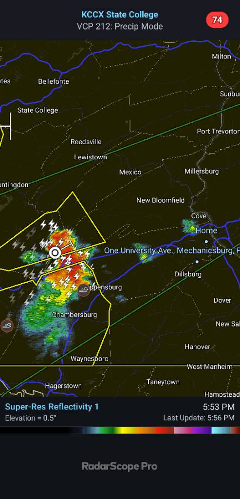
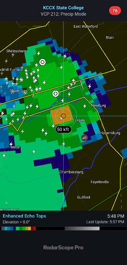
Central PA Summer 2026 Discussion/Obs Thread
Jns2183 replied to Voyager's topic in Upstate New York/Pennsylvania
These storms have explosive growth. 50k+ tops are not exactly common here Sent from my SM-S731U using Tapatalk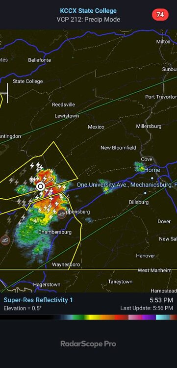

-

Big Heat (and storms?) Week into July 4th Weekend
AnEndlessMaze replied to yoda's topic in Mid Atlantic
This storm is nuts. -

Central PA Summer 2026 Discussion/Obs Thread
pasnownut replied to Voyager's topic in Upstate New York/Pennsylvania
Happy 250 all. Happy to live in such a free country that we do. Stay cool and hopefully we'll all get some rain tonight tomrrow. Lawn is toast. Nut -
pea-sized hail. and the winds shifted to the opposite direction when it began hailing so i think there was some rotation.
-
2026 Mid-Atlantic Severe Storm General Discussion
SnowenOutThere replied to Kmlwx's topic in Mid Atlantic
I’m included even in northern PA!- 947 replies
-
- 1
-

-
- severe
- thunderstorms
- (and 7 more)
-
 Temp dropped to 79/Heavy Shower
 -
Central PA Summer 2026 Discussion/Obs Thread
pasnownut replied to Voyager's topic in Upstate New York/Pennsylvania
FWIW I agree w/ Trainer 100%, as i'm sure you know. I enjoy your stats. Some of the complainers, should look in mirror when complaining about you/whatevs. -
WPC heavy rainfall discussion suggests that experimental WoFS guidance really lights up the 95 corridor over the next few hours.
-

Big Heat (and storms?) Week into July 4th Weekend
EastCoast NPZ replied to yoda's topic in Mid Atlantic
And a storm that misses to the north, of course. Lightning and thunder for the past 45 minutes and not a drop of rain. -
I am refusing to look at radar until it is on me. But getting a lot of thunder and my youngest said she looked at radar and there is a lot of lightning.
-
You're getting the goods. Looking at all that lightning on radarscope.
-
Big Heat (and storms?) Week into July 4th Weekend
AnEndlessMaze replied to yoda's topic in Mid Atlantic
Haven’t seen any hail but the wind portion of the severe is certainly verifying. Very heavy rains and lots of lightning.