All Activity
- Past hour
-
I got down to 27f. I've paid the oil company enough already and would really like to shut the heat off until November.
-

2026-2027 El Nino
A-L-E-K replied to Stormchaserchuck1's topic in Weather Forecasting and Discussion
-
Drought to worsen and fire conditions ramp up this weekend with warm temps, dewpoints in the low 50s and breezy conditions. Some signs of a more seasonally average shower/storm chances returning late next week. Hopefully the quick ramp up towards EL nino over the next few weeks will help to shake up the pattern and break down the ridge
-
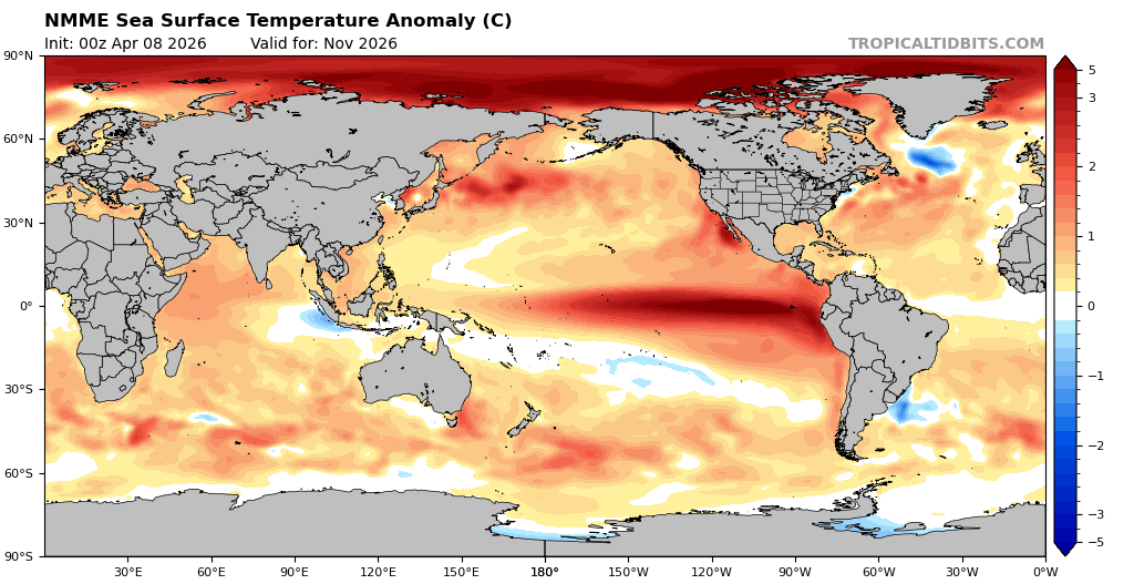
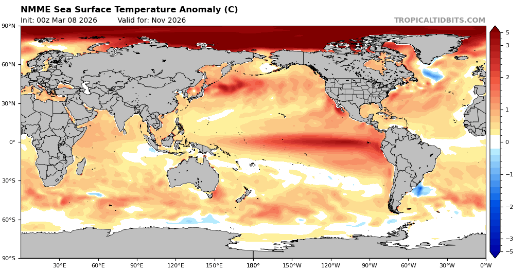
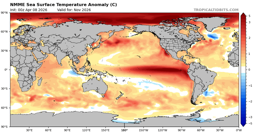
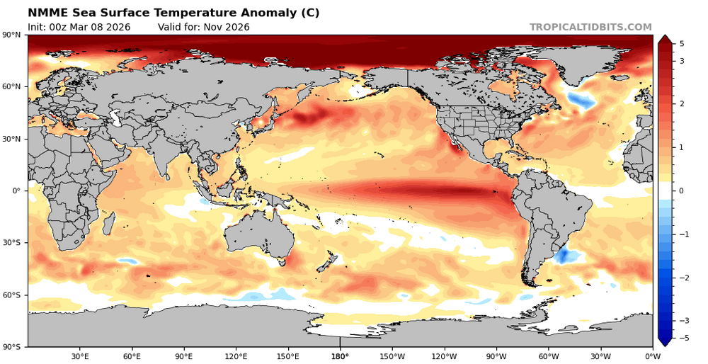
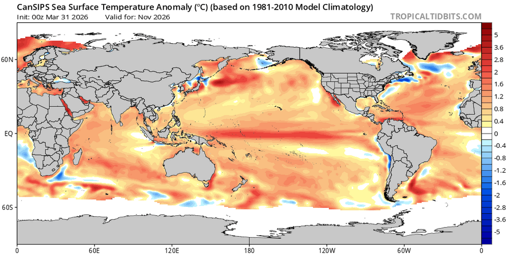
Nov: NMME is warmer than its prior run and much more E based than Cansips Modoki: Nov SSTa NMME latest run: Nov SSTa NMME prior run: Nov SSTa Cansips
-
23° for the low. Hopefully the last hard freeze until fall
-
April 8 1805: John Sayer at the Snake River Fir Trading Post near present day Pine City mentions: 'The most tempestuous (stormy) day of the year. Pines and other trees fell near the fort.' ^Note: Would seem a line of stms with strong straight line winds, or even a weak tornado, passed through EC MN region. A bit unusual this time of year this far N.^ For Wednesday, April 8, 2026 1919 - A tornado swarm in northern Texas resulted in the deaths of 64 persons. (David Ludlum) 1926 - The lightning-set oil depot fire near San Luis Obispo CA boiled over and engulfed 900 acres. Many tornado vortices resulted from the intense heat of the fire. One such tornado traveled 1000 yards, picked up a house and carried it 150 feet, killing the two occupants inside. (The Weather Channel) 1973 - A severe storm brought high winds and heavy snow to Iowa. Belle Plain received 20 inches of snow, and 19 inches blanketed Dubuque, record totals for both locations for so late in the season. Snow drifts up to sixteen feet high closed highways. (David Ludlum) 1987 - A cold front crossing the Northern Plateau and the Northern Rocky Mountain Region produced high winds in northeastern Wyoming. Winds gusting to 69 mph at Sheridan WY downed power lines and caused some property damage. (The National Weather Summary) (Storm Data) 1988 - Strong northerly winds ushered cold air into the north central U.S. The strong winds, gusting to 60 mph at Rapid City SD and Williston ND, reduced visibilities in blowing dust over the Dakotas. (The National Weather Summary) (Storm Data) 1989 - Two dozen cities in the southwestern U.S. reported new record high temperatures for the date. Phoenix AZ equaled their record for April of 104 degrees established just the previous day. (The National Weather Summary) 1990 - Twenty-two cities reported record low temperatures for the date as readings dipped into the 20s and 30s across much of the eastern U.S. Freezing temperatures severely damaged peach and apple orchards in West Virginia, where prolonged mild weather since January had caused an early blooming of spring vegetation. State and Federal agencies estimated a 50 percent loss in production for peaches and "Delicious Red Apples". (The National Weather Summary) (Storm Data) Note: That's one serious firenado WOW!
-
The only thing I can see is GWDLT
-
32 for the low
-
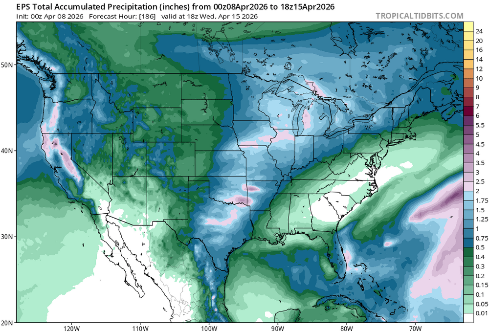
you can see the snow coverage pretty fantastically here... https://weather.cod.edu/satrad/?parms=subregional-New_England-02-24-1-100-1&checked=map&colorbar=undefined
-
Certainly can't rule that out this early in the season
-
ha... watch, the polar boundary ends up PIT - ACK ...and we have 38 -r with one or two pellets that day
-
Yeah, 3" seems a lot. It may be enough 'in the bank' to last it out.
-
March finished as 3rd warmest on record at RDU
-

E PA/NJ/DE Spring 2026 Obs/Discussion
BBasile replied to PhiEaglesfan712's topic in Philadelphia Region
Temp got down to 29.4F this morning. Currently 37. -
Sublimation is a stronger latent cooler than evaporation. We had over 3”. I expect it to mostly be gone by evening, but I don’t think we bust warm until tomorrow. Tonight looks like another strong rad night in the pits.

-
https://coolwx.com/record/
-
I agree with that, however, I think what we'd have to watch for is cloud cover from upstream precipitation/convection...though perhaps shear vectors favor us avoiding this mess.
-
I doubt it... The continent is too dry. The flow is WSW under that polar boundary transporting a kinetically charged well mixed layer originating from the west TX high country. Good luck. If we are safely in that warm conveyor like the GFS? not much cloud. That's a red flag warning scenario there this early and prior to our own geographical green up. Even if the RH sigmas are juicier ( 800 to 300 mb levels) I'd personally lean on that being dryer verifying.
- Today
-

Central PA Spring 2026 Discussion/Obs Thread
mahantango#1 replied to Voyager's topic in Upstate New York/Pennsylvania
We might have to go through litigation on this one. -
Well I hope the GFS OP is wrong, aside from those two warmish days next week. I'll believe the more consistent flip to mild when I see it. Euro looked slightly better, and AIGFS was pretty mild so we hope those are more on track
-
Perhaps the coldest morning, this late in the season, since 1997! Was there any record lows, this morning?
-
Light/very light SN 3:30-9:15 PM, brief better flakes accum 0.2" by 4:30 but melted by 5. 2nd band dropped 2.0" of 22:1 feathers 9:15-10:45, a dusting came later. Fake low of 14 this AM, full sun now.
-
Wednesday could be socked in with clouds, though could be some potential to get some breaks in
-
Yeah, I'm also at the same time a little apprehensive about going super warm at any point prior to getting that fucking piece of shit 90/60 negative anomaly scoured out of the Canadian Shield once an for all. It's not like it's very readily observable as an influence, but it is definitely an influence our our weather, nonetheless. The polar boundary with the exceptional temperature gradients we've been observing along the S periphery of the rough NP-GL-NE/MA regions is because it is up there, perpetually loading dope cold into those regions ( or attempting to); at the same time there's a CC residue/tendency to go above normal where ever and when ever the sun is working on Industrial stained atmosphere underneath it. Historic heat wave in PHX, notwithstanding. Lot of descriptive prose in there that probably lost the comprehension of about 6 return users ...with a possible 7th, but excluding those razor sharp contributors to the site brain, most people are aware of both the frequency, and rareness, of 34 to 80 across a mere 200 miles phenomenon recurring this spring so far. In addition to steepening the gradient ...it also prones our region to BDs and/or failing warm frontal positions in general. But, you know ... there are two aspects concurrently true, and are observationally competing. We are not hugely below normal in temperatures to date - in fact, +3 in March at HFD and ORH! The pattern is a colder than normal construct. That concurrent state is a nuance that I fully personally believe exposes the fact that heat is merely just suppressed, but not absent. And there is a difference there. Whopping important one, too. For one, it's confusing... but for another, it's hard to go multi-day safely in a warm sector while all this stuff is in play.
-
Records: Highs: EWR: 88 (1991) NYC: 90 (1991) LGA: 89 (1991) JFK: 82 (1959) Lows: EWR: 23 (1982) NYC: 25 (1982) LGA : 25 (1982) JFK: 26 (1982) Historical: 1862: Snow at Atlantic City, NJ was deep enough to support an early spring sleigh ride. (Ref. Wilson Wx. History) 1918: A big spring snowstorm buried the Potomac Highlands of West Virginia with 34 inches of snow at Wardensville, 30 inches at Moorefield, and 29 inches at Romney. (Ref. Wilson Wx. History) 1919 - A tornado swarm in northern Texas resulted in the deaths of 64 persons. (David Ludlum) 1926 - The lightning-set oil depot fire near San Luis Obispo CA boiled over and engulfed 900 acres. Many tornado vortices resulted from the intense heat of the fire. One such tornado traveled 1000 yards, picked up a house and carried it 150 feet, killing the two occupants inside. (The Weather Channel) 1929: EARLY HEAT WAVE-The maximum temperature for the date is 93°F. in Washington, DC. Heat wave set three records in a row 92°, 94°, 93° on the 6th-8th in Washington, DC. (Ref. Washington Weather Records - KDCA) 1938: Snow began to fall over central Oklahoma during the previous evening and continued to this day. In Oklahoma City, several snowfall records for the month soon fell to the storm, including the record for most total snowfall during the month of April. The Oklahoma City snowfall totals of 0.8 inches on the 7th, and 3.3 inches on the 8th, remain daily records. In fact, the 3.3 inch snowfall on the 8th is the most ever to fall on any single April day. The 4.1 inch total for the month continues as the greatest April monthly snowfall total. (Ref. Wilson Wx. History) 1952: A huge ice jam broke up on the Missouri River in North Dakota, resulting in rapid rises of up to 8 feet downstream. The river flow jumped from 75,000 cubic feet per second to over 500,000 cubic feet per second. (Ref. Wilson Wx. History) 1956: After daytime highs in the 60s, snow along with thunder and lightning occurred across southwest Kansas. Over 5 inches of snow fell at Dodge City with 4 inches at Garden City. Winds gusted to over 70 mph in the Texas panhandle with zero visibility and blowing dust. A strong tornado hit near Enid, OK. (Ref. Wilson Wx. History) 1958: The global record for most rainfall in 48 hours was set at Aurere, La Reunion Island beginning on this date from a tropical cyclone when 97.1 inches fell. (Ref. Wilson Wx. History) 1972: The minimum temperature for the date is 29 °F. in Washington, DC tied with 1982. (Ref. Washington Weather Records - KDCA) Richmond, VA had a high temperature for the day of 37°F matching the coldest April day on record (records since 1897). The other date of 37 °F was April 3, 1915. (Ref. Richmond Weather Records - KRIC) 1973 - A severe storm brought high winds and heavy snow to Iowa. Belle Plain received 20 inches of snow, and 19 inches blanketed Dubuque, record totals for both locations for so late in the season. Snow drifts up to sixteen feet high closed highways. (David Ludlum) 1982: The minimum temperature for the date is 29°F. in Washington, DC tied with 1972. (Ref. Washington Weather Records - KDCA) Severe crop and property damage occurred from a major hailstorm in Seminole Co, FL. (Ref. Wilson Wx. History) 1987 - A cold front crossing the Northern Plateau and the Northern Rocky Mountain Region produced high winds in northeastern Wyoming. Winds gusting to 69 mph at Sheridan WY downed power lines and caused some property damage. (The National Weather Summary) (Storm Data) 1988 - Strong northerly winds ushered cold air into the north central U.S. The strong winds, gusting to 60 mph at Rapid City SD and Williston ND, reduced visibilities in blowing dust over the Dakotas. (The National Weather Summary) (Storm Data) 1989 - Two dozen cities in the southwestern U.S. reported new record high temperatures for the date. Phoenix AZ equalled their record for April of 104 degrees established just the previous day. (The National Weather Summary) 1990 - Twenty-two cities reported record low temperatures for the date as readings dipped into the 20s and 30s across much of the eastern U.S. Freezing temperatures severely damaged peach and apple orchards in West Virginia, where prolonged mild weather since January had caused an early blooming of spring vegetation. State and Federal agencies estimated a 50 percent loss in production for peaches and "Delicious Red Apples". (The National Weather Summary) (Storm Data) 1994: 7 to 9 inches of rain fell over a 3-day period causing the Missouri River at Boonville, MO to rise 14 feet and at Hermann, MO to rise 19 feet. (Ref. Wilson Wx. History) 1996: The first of two late season heavy snowfalls in only three days over the Northeast dumped 12 inches of snow at Slide Mountain, NY, 10.2 inches, at Ashburnham, MA, and 7 inches at Falmouth, Massachusetts. The 6.1 inches at Binghamton, NY brought its seasonal snowfall total to 131.8 inches; their snowiest winter ever. Incredible flooding continued on the Minnesota River in Minnesota. Thousands of people were driven from their homes by the flooding, which was complicated by blizzard conditions and record cold. (Ref. Wilson Wx. History) 1997: Miles City, MT only reached 5° tying their coldest April reading ever with 4/15/1986. They did not reach 30° from the 5th through the 10th. (Ref. Wilson Wx. History) 1998: A major F5 tornado struck western Jefferson county Alabama leveling the communities of Oak Grove, Rock Creek, Edgewater, McDonald's Chapel, Sylvan Springs and Pratt City. The tornado lifted just two miles from downtown Birmingham. The twister had a track of 20 miles with the damage path averaging between ½ and ¾ of a mile in width. 34 people were killed, 221 injured and 1,000 homes were destroyed. (Ref. Wilson Wx. History) An F2 tornado destroyed a mobile home near Coal City, Alabama. The clothes dryer was found 250 yards from the home site-with a 3 year old girl inside it. Evidently her parents had put her in it hoping she would survive (she did). Unfortunately the parents were killed by the tornado. (Ref. Weather Guide Calendar with Phenomenal Weather Events 2012 Accord Pub. 2011, USA) 1999: A windstorm caused $20 million dollars in damage along the front range from Fort Collins, CO south to Pueblo, CO and to the east over the Plains. This storm was equal to the costliest windstorm on record occurring on 1/17/1982 at Boulder, CO. In the Denver area, there was damage to homes including roofs, broken fences, awnings, doors and windows. Multiple accidents resulted including several tractor-trailers blown on their sides. Power lines were downed causing a few small grass fires. The highest wind gusts reached 112 mph atop the Niwot Ridge near the Continental Divide west of Boulder, 102 mph at Wondervu, 100 mph at NCAR in Boulder. Winds of 98 mph were recorded at the National Wind Technology Center near Broomfield, 96 mph on Rocky Flats, 92 mph at the Jefferson County Airport. Several tornadoes touched down across central Illinois, as a complex of severe thunderstorms moved across the region. In Hancock County, the town of Hamilton had significant damage, with 144 homes destroyed or damaged by a tornado of F3 strength. Two radio and TV towers were also destroyed. Damages totaled to about $10 million. In far southeast Cass County, one person was killed in Ashland, when a tornado hit a trailer park. Damage in Ashland was estimated around $1.8 million dollars. Further east, another tornado destroyed a trailer north of Cisco, killing a second person. Five separate tornadoes caused F2 damage in Knox, Boone, Lewis, and Pike counties in Missouri and Pike County in Illinois. Seven people were injured. (Ref. Wilson Wx. History) 2003: A severe thunderstorm with wind-driven hail up to 3 inches in diameter hit Brownsville, Texas, injuring 5 people and causing $50 million dollars in damage. It was one of the most destructive hail events ever for the city. (Ref. Wilson Wx. History) 2013: The 8th of the top 10 US weather events of 2013 was a Great Lakes winter storm and plains of April 8 through the 12th. An enormous storm system tracked from the Great Basin to the Great Lakes, dropping over a foot of snow from Wyoming to Minnesota, including 28 inches at Rapid City, South Dakota-an all-time record. This storm also hit the plains and South with large hail and tornadoes and spread severe thunderstorms from Texas into Pennsylvania. (Ref.Weatherwise May/June 2013 page 15)