All Activity
- Past hour
-

E PA/NJ/DE Spring 2026 Obs/Discussion
RedSky replied to PhiEaglesfan712's topic in Philadelphia Region
Today's euro mega torches after next Wednesday, a week of false spring? -

Clipper Fires In Wednesday Feb 25 Disco/ Obs
codfishsnowman replied to Damage In Tolland's topic in New England
Especially with the timing...at least for most of CT. Was there even a special weather statement? -
Beer?
-

E PA/NJ/DE Winter 2025-26 Obs/Discussion
MJO812 replied to LVblizzard's topic in Philadelphia Region
Gefs is impressive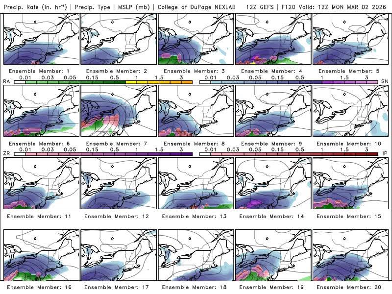
-

E PA/NJ/DE Winter 2025-26 Obs/Discussion
Kevin Reilly replied to LVblizzard's topic in Philadelphia Region
Canadian Geese migration begins in front of 80+ degrees March 12th? -
It came north.
-

Pittsburgh/Western PA WINTER ‘25/‘26
RitualOfTheTrout replied to Burghblizz's topic in Upstate New York/Pennsylvania
Right now I think we are right where we want to be. Some models North, some to the South. Don't really want any more South on that GFS op run though. -
I think it may be over cooked. Admittedly don't have a lot of confidence though. I've seen this in the past where these early season modeled warm bulges end up 18 hours of misty warm sector. I've literally seen a D11-14 run of 75 F days end up verifying one day of 62. What happens is the progressive footprint sped up the frontal advance 1 hour/run for week's worth until the first 2 days are claimed. Meanwhile, the wedged in BD air mass is 18 hours too fast to erode out in the guidance. No one wins. no snow. warmth gypped. This one does have the index/ens spacial synoptics backing the -PNA, so we'll see. I'm perfectly happy with melt and mud and leave it at that for now... which no one wins in that boredom either. Ha
-
We're watching the poor guy's deep well of optimism be cannibalized by Stein and run dry in real time. Sad.
-
Hopefully we can grab that next week because it's Napes afterwards for a bit.
-

Central PA Winter 25/26 Discussion and Obs
Jns2183 replied to MAG5035's topic in Upstate New York/Pennsylvania
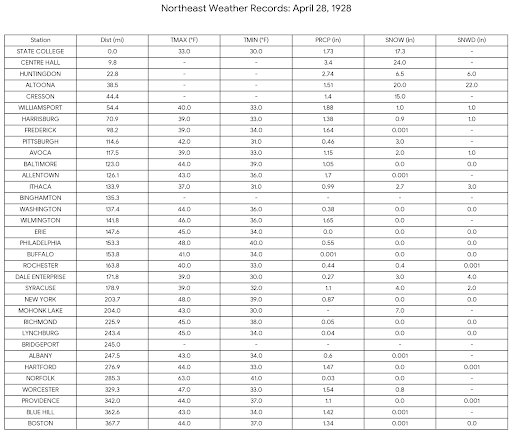
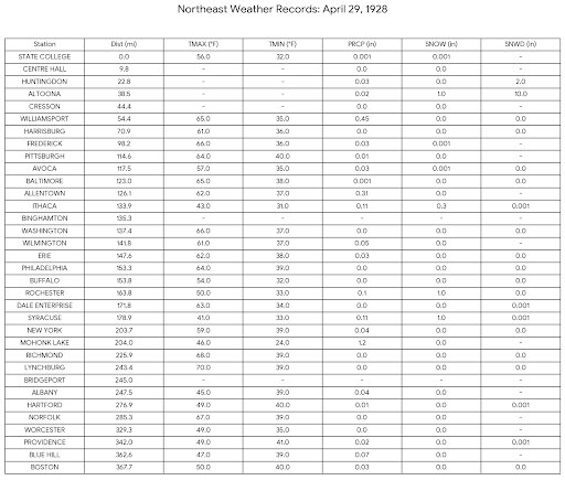
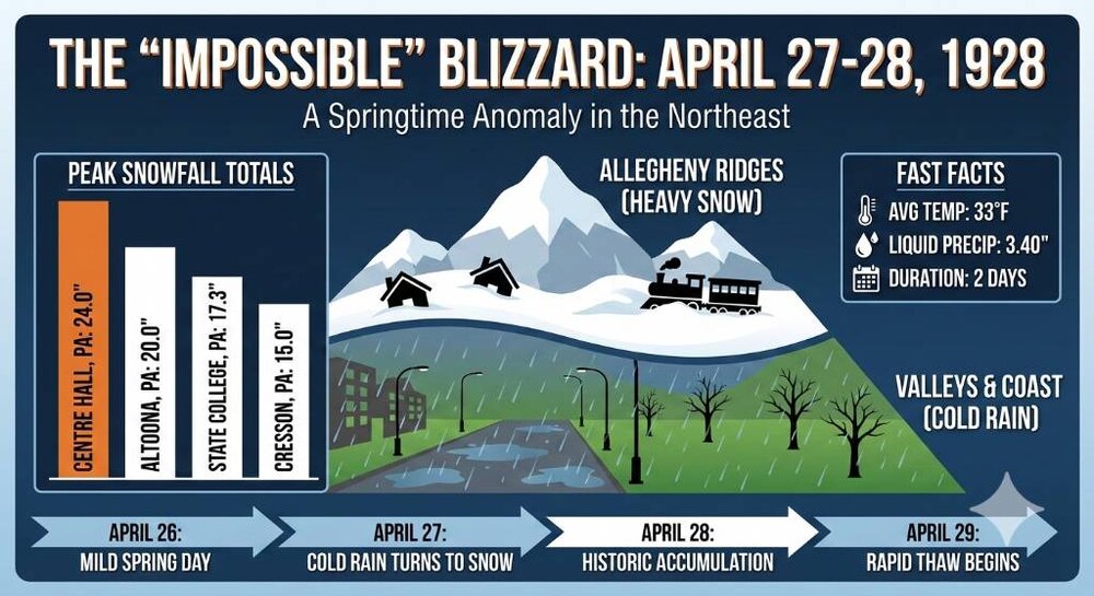
Here are station reading that Friday, Saturday, Sunday. Most snow fell on Saturday. By Sunday it was up near 60 if not above. Absolutely bonkers storm that dropped a ton of preceiptitation. I wish I had the low track and pressure readings for that bomb. Sent from my SM-S731U using Tapatalk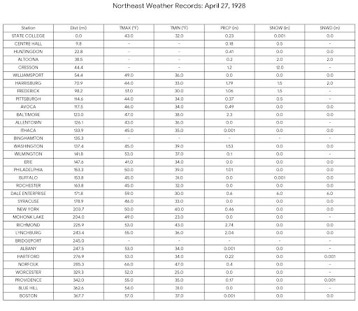
-

Outta gas and Outta Time: Early March Winter Storm finale
LeesburgWx replied to Ji's topic in Mid Atlantic
Cannot believe March snow is going to possibly be our best event this year. 64 weenies following this instead of working too -
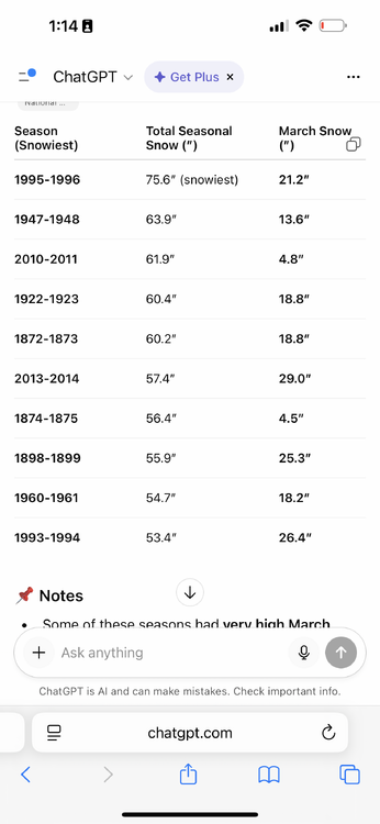
https://www.weather.gov/media/okx/Climate/CentralPark/monthlyseasonalsnowfall.pdf Looks like snowiest all time was 1895-96 at 30.5”. Snowiest recent was 14-15 at 18.6” Despite what people say 13/30 winters in 1990-2020 had over 5” with many more in the 3-5 range. Only around 1/3rd were less than 3”.
-
Outta gas and Outta Time: Early March Winter Storm finale
RitualOfTheTrout replied to Ji's topic in Mid Atlantic
Are you sure about that?
-
E PA/NJ/DE Winter 2025-26 Obs/Discussion
Kevin Reilly replied to LVblizzard's topic in Philadelphia Region
It was south over southern Pa and NJ -
I’m wondering if the projected early March SSWE could end up as a SFW, a subject @snowman19knows as much about as just about any regular here. Below is yesterday’s EW, which suggests it will reverse March 3-5. It also suggests there’s only a very low probability for this to end up as a SFW as there’s no more than 1-3% showing that: So based on that, there’s no reason as of now to expect this to be an SFW. However, what if the improbable event were to actually happen? It would be at or near a new record earliest SFW, which is currently March 5 (of 2016). Last year, which isn’t on this SFW table, was close with March 9-10, the 2nd earliest: @snowman19any opinion?
-
It sounds like he doesn’t need anymore snow
-
The ultimate tease.
-
Nape-tastic out here at the moment
-
-

Outta gas and Outta Time: Early March Winter Storm finale
stormtracker replied to Ji's topic in Mid Atlantic
So between the two camps we have what appears to be a 90-100% frozen event. I mean, ideally we want the snowiest solution...but seems like we'll be tracking something that could be better for us than the great GFS mirage storm -

Outta gas and Outta Time: Early March Winter Storm finale
Terpeast replied to Ji's topic in Mid Atlantic
Probably the last trackable event of the year. If it comes to fruition, it may get me to my median climo. Once again, I’m waiting until lead times of 84-96 hours or less to really buy in. -
To clarify my prior post I meant the SWFE is not South for next week, not the Thursday ghost threat. But I guess all SWFE should go in the March thread to avoid any confusion
-

Outta gas and Outta Time: Early March Winter Storm finale
WxMan1 replied to Ji's topic in Mid Atlantic
I see what the EC Kuchera is showing. But as it's progged right now synoptically, this 'feels' more like your typical 2-4" with the front end snow, then some sleet, then some FZRA/DZ to end. -