All Activity
- Past hour
-
Yeah, flurries here and overcast, wasn't in the forecast.
-

Is we back? February discussion thread
Damage In Tolland replied to mahk_webstah's topic in New England
Clouds FTW today #Protectthepack -

February 2026 OBS & Discussion
CPcantmeasuresnow replied to Stormlover74's topic in New York City Metro
35 here with light snow. This is kind of unexpected. -
 It's February 11th
 -
Clouds moved back in here from the NW-up to 36-roads now just wet
-

2025-2026 ENSO
40/70 Benchmark replied to 40/70 Benchmark's topic in Weather Forecasting and Discussion
The North Pacific pattern is what is most crucial. -
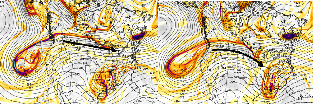
Yeah, I'm not a big fan of cute handling, in general. Not until quantum computing takes over ha. These larger smoothing techniques are as important in the total deterministic effort - or should be. I don't like the fact that the 00z doesn't phase that small intermediate stream S/W. It just had more power in the S stream, and by virtue of that...it got closer - but still short of getting it done. Then the 06z arrives. Technically, it's not even a phase. The southern aspect is pealing away S ...not that dissimilar to the GFS. It's just that it's taking that intermediate wave the GFS doens't curve in, and abruptly stemwinding that feature. It's enough of a continuity break in total handling to pause.
-

Pittsburgh/Western PA WINTER ‘25/‘26
TimB replied to Burghblizz's topic in Upstate New York/Pennsylvania
When 93 drops out of the normals (just five years away from that!), we’ll lose probably about a full inch out of that 7.6”. -
2025-2026 ENSO
40/70 Benchmark replied to 40/70 Benchmark's topic in Weather Forecasting and Discussion
Posted this in the new thread, but meant to post in here. -
Big melt day today. Probably upper 40s for highs. This time of year without clouds we usually overshoot expected highs with the sun getting stronger every day and no leaves on the trees.
-

Feb 10-11 Mid Week Minor Event - Ride the hot hand?
mahk_webstah replied to HoarfrostHubb's topic in New England
This is why I love snow pack so much. Walking around this morning you would think we just had a 2 foot snowfall that ended overnight. Blue gray sky a few flurries drifting down huge snow piles and 2 feet on the ground. Every time it snows more than two or 3 inches now it feels like a big storm. -

Pittsburgh/Western PA WINTER ‘25/‘26
colonel717 replied to Burghblizz's topic in Upstate New York/Pennsylvania
I curiously watch them all. Just not highly invested because such low odds. It's just as Mike said there is no support outside of CMC which is on an island. There is just not much cold air to tap even if we do get a perfect track. -

February 2026 Medium/ Long Range Discussion: 150K Salary Needed to Post
Nomz replied to Weather Will's topic in Mid Atlantic
Looks like our last shot for snow this season -
Feb 10-11 Mid Week Minor Event - Ride the hot hand?
mahk_webstah replied to HoarfrostHubb's topic in New England
Wow, is it deep. Hadn’t been for a woods walk for a while so I just checked the steak in the woods and we’ve got 25 inches. Keep getting these nice surprises on the small events which have been ramping up just before go time. -
Is we back? February discussion thread
40/70 Benchmark replied to mahk_webstah's topic in New England
Still side with the GFS here, but may change my mind after 12z. -
Have my first open grass patch on my north facing hill slope. But most of the lawn is still probably 5”+ depth. Just walked on it though to refill the bird feeder and I broke through the crust with nearly every step.
-

E PA/NJ/DE Winter 2025-26 Obs/Discussion
Albedoman replied to LVblizzard's topic in Philadelphia Region
The winter deserves an A- with a big the help of a huge class curve given by the teacher based on all of the misses the last three weeks with potential storms. Its like we have three bad tests of potential winter storms and the teacher is throwing them out to raise the average class scores to achieve an A- with the cold temps and snow cover. lol -
43
-

Feb 10-11 Mid Week Minor Event - Ride the hot hand?
Frostyinthe603 replied to HoarfrostHubb's topic in New England
I'd say about 6" here in Nottingham. It was a nice little blitz fort sure! -
so in trying to analayze the behavior of the -PNAP response to the -PNA... it appears the GFS and in fact the GEFs system on whole is assessing a quicker -PNAP response, overall. The slightly slower Euro system in moving the conus into the -PNAP response, constructs critical curvature in the W. That subtle lag is tipping/conducting the N stream to dump small S/W space crucially SE through roughly MN is the 06z Euro version. Flat happy GFS left ... curve happy Euro right That's the whole ball game... this really subtle variance allows some kind of delicate phasing opportunity in the Euro system.
-
This November 2012 example of a system that started with barely cold marginal airmass in place and it was silll Fall ! All of this snow was created by dynamic cooling. This weekend system has the potential of creating a similar dynamic cooling event and this will be in a more favorable mid- February environment with cold water temps also. Also factor in the layer of ice that will still be present on the surface - not much to interfere with the dynamic cooling - except if the systems don't phase Snow storm, November 7-8, 2012 - Storm Summary
-
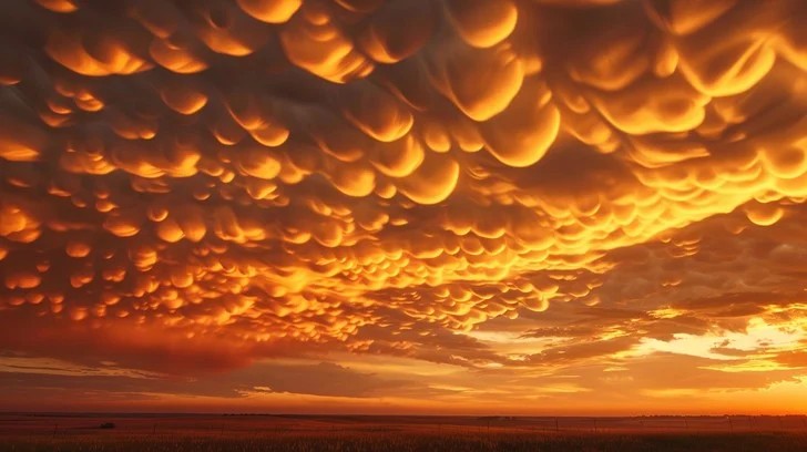
Mammatus cloud sunset. Rare but they happen in the dmv once in a while. Mammatus clouds behind a gnarly thunderstorm are wild but toss a sunset color pallet into it and it's other worldly. Not my pic but what a show here...
-
Skiing on a ruptured ACL(!) and it didn't even look like she had a decent brace on, which is unfathomable, unless it's against Olympic regulations?
-

Feb 10-11 Mid Week Minor Event - Ride the hot hand?
Great Snow 1717 replied to HoarfrostHubb's topic in New England
Part of the backyard within 10-12 feet of the home receives no sunlight so it is a protected spot...has its own microclimate lol -
Depends where you are in the forum-long Island the city and the jersey coast are way different than your area. I'm somewhere in the middle. Always said 3/10 or so was the end around here with the exception of March 2018 type patterns.


.thumb.png.4150b06c63a21f61052e47a612bf1818.png)