All Activity
- Past hour
-
The SPC and NWS are off the wall over atmospherics that the models are wondering, whats all the excitement about??? I'm under a Flash Flood Watch and Tornado Watch. I will receive neither....................
-
18z HRRR still throwing out severe-level winds on the backside as the low is passing by.
-
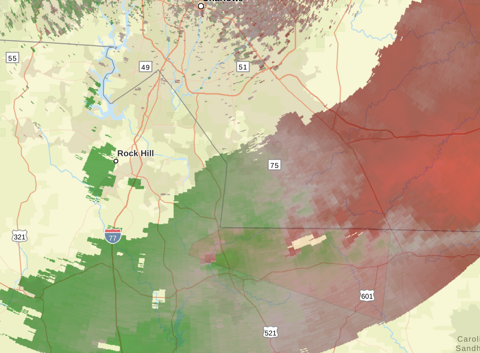
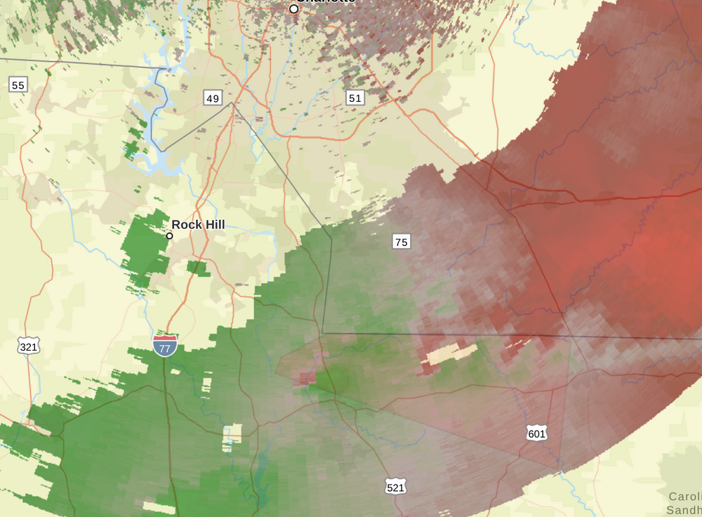
Severe Weather Statement National Weather Service Columbia SC 359 PM EDT Fri May 30 2025 SCC025-057-302015- /O.CON.KCAE.TO.W.0009.000000T0000Z-250530T2015Z/ Lancaster SC-Chesterfield SC- 359 PM EDT Fri May 30 2025 ...A TORNADO WARNING REMAINS IN EFFECT UNTIL 415 PM EDT FOR CENTRAL LANCASTER AND NORTHWESTERN CHESTERFIELD COUNTIES... At 359 PM EDT, a severe thunderstorm capable of producing a tornado was located near Buford, or 8 miles northeast of Lancaster, moving east at 35 mph. HAZARD...Tornado. SOURCE...Radar indicated rotation. IMPACT...Flying debris will be dangerous to those caught without shelter. Mobile homes will be damaged or destroyed. Damage to roofs, windows, and vehicles will occur. Tree damage is likely. This dangerous storm will be near... Buford around 405 PM EDT. Other locations impacted by this tornadic thunderstorm include Camp Creek Fire Station, Taxahaw, Unity Fire Station, Arrowood Estates, Tradesville, and High Point Fire Station. PRECAUTIONARY/PREPAREDNESS ACTIONS... TAKE COVER NOW! If you are outdoors, in a mobile home, or in a vehicle, move to an interior room or closet on the lowest floor of a sturdy building immediately. && LAT...LON 3482 8079 3482 8047 3481 8042 3465 8044 3477 8087 3479 8086 TIME...MOT...LOC 1959Z 276DEG 30KT 3480 8065 TORNADO...RADAR INDICATED MAX HAIL SIZE...<.75 IN $$ This is a tornado warning for Union County, NC, Lancaster County, and Chesterfield County, SC. Of course, the NWS doppler radar hole around Metro Charlotte is causing the velocity reflectivity to be very blurry. The CLT Terminal Doppler is severely limited in range of reflectivity.
-
the short term forecasts have at least 45 kt of shear (effective) over mid Virginia, so sure.
- 813 replies
-
- 1
-

-
- severe
- thunderstorms
- (and 2 more)
-
Not many changes at 20z, just some adjustments north and “trimming”. rest of outlook is same as previous. ...20Z Update... The primary change to the Day 1 Convective Outlook was to slightly expand severe probabilities farther north in NJ to account for placement of stronger storms likely preceding the surface low track. The western bounds of severe probabilities were also trimmed to account for the passage of the surface low and surface cold front. Otherwise, the previous forecast (see below) remains on track. ..Squitieri.. 05/30/2025
-
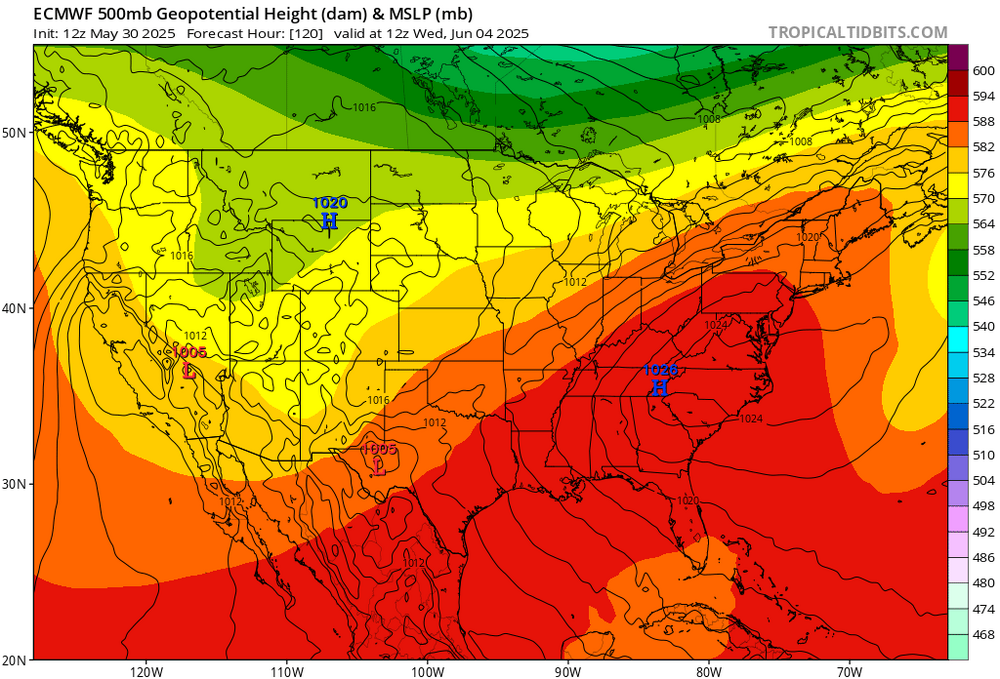
Looks impressive… maybe even anomalous!
-
Have to believe that 12Z type solution is going to set up sooner rather than later. Hard lean from me on first 90 at usual warm spots mid to late next week. Pattern is going to flip and hold very soon.
-

Central PA Spring 2025
Itstrainingtime replied to canderson's topic in Upstate New York/Pennsylvania
I need 2.74" to reach that mark. -
MCD out for the immediate region. Mesoscale Discussion 1044 NWS Storm Prediction Center Norman OK 0249 PM CDT Fri May 30 2025 Areas affected...Parts of eastern VA...MD...DE...northeastern NC...and far southeastern PA Concerning...Severe potential...Watch likely Valid 301949Z - 302145Z Probability of Watch Issuance...80 percent SUMMARY...The risk of damaging wind gusts and a few tornadoes will increase in the 22Z-00Z time frame. A watch will likely be issued for parts of the area within an hour or two. DISCUSSION...Latest surface analysis shows a surface low over northern WV, with a quasi-warm front extending eastward across MD into southern NJ. Along/south of the front, diurnal heating within cloud breaks and lower/middle 60s dewpoints are contributing to around 1500 J/kg MLCAPE. As storms spread/develop eastward into the destabilizing air mass, 40-50 kt of effective shear should favor gradual intensification/organization into semi-discrete clusters and supercells. Enhanced clockwise hodograph curvature (around 150 m2/s2 effective SRH) ahead of the east-northeastward-moving surface low will support the potential for a few tornadoes (along with locally damaging wind gusts) with the more organized supercells that evolve. A watch is likely for parts of the area within an hour or two. ..Weinman/Smith.. 05/30/2025
- 813 replies
-
- 1
-
-
- severe
- thunderstorms
- (and 2 more)
-
Central PA Spring 2025
Itstrainingtime replied to canderson's topic in Upstate New York/Pennsylvania
I'm just the opposite. I wish like heck that threat moved way south. Don't like severe weather. Ever. -
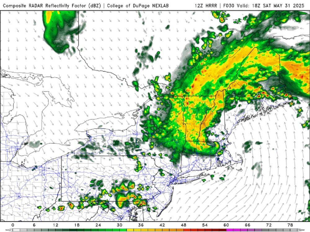
There are these wx sayings, "similar patterns breed similar storms" and "when it's good, it can be REAL good!" First, I will get this out of the way, CoastalWx is once again STEAMED this did not happen in this past winter! This storm is almost a carbon copy of the last storm, except everything is ~100 mi NW. The 500 trough evolution is ideal. The trough over the Mid-Atlantic is at first neutrally titled, and does a full 90 deg swing negative as it moves across New England. That's how you do it for a classic! The last storm did this as well. 982 mb for a central pressure over New England is very impressive for late May. I can not recall a low this deep here this late, esp. over land. Embedded tstms look to be widespread, even the cool sector of the storm. Few hundred CAPE is common across the region on the models as the storm winds up. That does not happen often w/ a Nor'easter, but given it is late May, by default you will have some CAPE around. Big R+ potential in western sections w/ the deformation. Can it look any more classic on the HRRR forecast radar valid 18z Sat? Snow once again likely in the mtns (above 4000 ft this time) and probably several inches on Mt Washington as a rather cold air mass for this time of year flushes in behind the storm.
-
oh that high in the 12z run is in a GREAT spot, there would be a downsloping westerly or northwesterly wind with a high in that position !!
-
Yikes. Still, the weather geek in me wishes that threat was up to I-80 instead of US-30. I've got the video cameras out, so it would make an interesting finish to my work night and video
-
The location of the upper low holds the key to our first 90°. If it gets out of the way like the 12z run today, then we’ll have our first 90° next week at the usual warm spots. More of a 0z solution then we’ll top out in the 80s. This is a pretty big jump in just one run. But models usually struggle with closed low solutions. 12z 0z

-
If Lebanon can pick up 2.80”+ before the end of the month we will hit 12” of rain on the month…amazing .
-
Correct me if I'm wrong but that would be a line of at least quasi-supercellular activity?
-
Sun popped out a bit more here and temps went from 74 to 78
-
HRRR for a few hours in the future
- 813 replies
-
- 2
-
-
- severe
- thunderstorms
- (and 2 more)
- Today
-
I think our line we are watching is in WV right now for this evening
-
Central PA Spring 2025
Itstrainingtime replied to canderson's topic in Upstate New York/Pennsylvania
Severe threat until 1am, Tornado threat up to Rt. 30. Expecting everyone to get .5" - 1.5" of rainfall with some areas getting 3-4". More storms with hail tomorrow PM but more scattered and brief in nature. -
Radar seems ahead of schedule relative to meso models
-
Dark clouds and a pop up storm just east of me.
-

2025 Lawns & Gardens Thread. Making Lawns Great Again
dendrite replied to Damage In Tolland's topic in New England
I thought I had poison ivy coming up by my run, but after some careful leaf IDing I think it’s box elder. -
Still not sure what I was quoted for/getting called out on there... weather this week wasn't terrible we had a couple of nice days, but it wasn't that great either. Lots of overcast conditions, rained a few days, and now we have a 990 low tracking up the Appalachian's into the CT River for Saturday. Even after the low passes it's looking like drizzle and breezy conditions in it's wake until it pulls much farther north for Eastern New England. If this is COC - get to Planned Parenthood for a screening... Looks like the pattern will break next week (thankfully)...
-
next week may or may not offer a heat wave... I figure for the 80s mid week, but the ceiling is higher so we may manifest that more obvious as we get closer. we'll see. 12z GFS ends the run with big heat implication. Full bird SW/Sonoran release event... talkin 576 to 581 thickness from New Mexico to Boston Harbor. 360+ hours, so nothing can go wrong with that of course heh