All Activity
- Past hour
-

2025-2026 ENSO
Stormchaserchuck1 replied to 40/70 Benchmark's topic in Weather Forecasting and Discussion
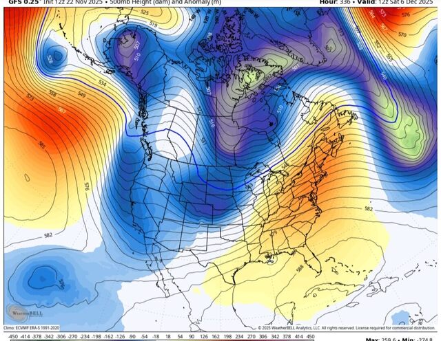
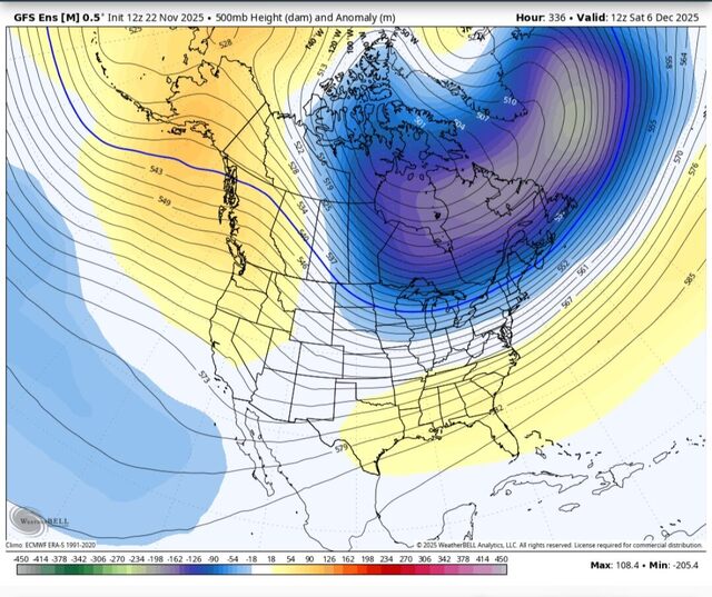
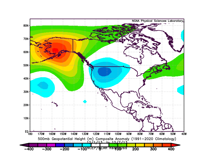
That's a +400dm mean ridge over Alaska for a 7-day period. Not really the same as the 1 panel you posted above. We are going to get a -EPO period but it's not going to be as strong or sustain like 2013. -
 .22 here. Sunny and warm now We lights
 -
Take the ops with a grain of salt
-
Amazing how that classic DT typo from years ago lives in infamy.....forever!
-
But it was a glorious week lol.
-
Don't tell them Eric Webb is getting excited about early December snow... for New Mexico
-
December, 2022. People were all but guaranteeing a December, 2010 redux with textbook KU’s bombing up the coast and the I-95 corridor getting dumped on. It was even called a historic setup by many and we were told to “buckle up, get sleep now, it’s coming”. The hype was off the charts for the better part of 2 weeks….
-

December 2025 Short/Medium Range Forecast Thread
Carvers Gap replied to John1122's topic in Tennessee Valley
I think the SW, multiple cutoffs to Baja....was an error. The GFS has a bias to be progressive, but because of that it will work this out more quickly. The 12z gfs and ensemble matched the 6z run. The CMC is still coming around. In fact, the GFS is flirting with snow around Dec7-8. My guess is that cuts along the Ohio River Valley. But things don't hang up...that cold front will come roaring through at the end of the first week of December. -
After the first few days, it get better for the east like I posted above using 2013. Also pretty sure the tropical system on gfs is bs
-
You absolutely could for northern areas, December 2007 is a good example. Depends on where the boundary sets up.
-

Fall 2025 Medium/Long Range Discussion
A-L-E-K replied to Chicago Storm's topic in Lakes/Ohio Valley
This is our moment -

Fall 2025 Medium/Long Range Discussion
Chicago Storm replied to Chicago Storm's topic in Lakes/Ohio Valley
Short and sweet for now… 2013. This is the best looking pattern on paper I can recall when heading into December since then. -
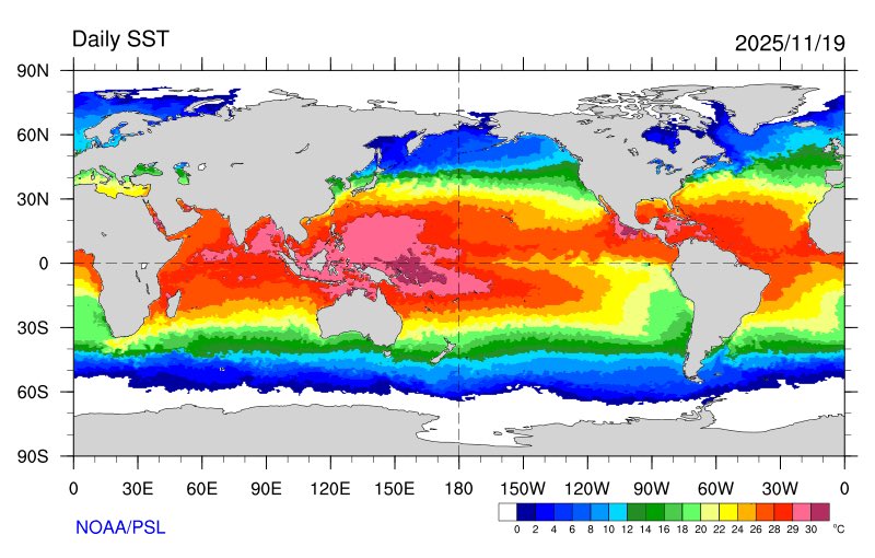
Eric Webb @webberweather The current global SSTa pattern is very favorable for the -EPO/+TNH pattern w/ the warmest water on the entire planet ~160E in the South Eq Pacific. The MJO is obviously giving it a huge boost here too. Eric Webb @webberweather · 16m I definitely underestimated how quickly this winter would dip into the ‘ol well of -EPO/+TNH we’ve seen so frequently the last 10-15 years. This pattern is only going to get stronger later in winter when the polar vortex intensifies& the warm pool starts zonally advecting east.
-

November 2025 general discussions and probable topic derailings ...
SJonesWX replied to Typhoon Tip's topic in New England
0.0” here, not even a drop. Last fall cleanup completed this morning -
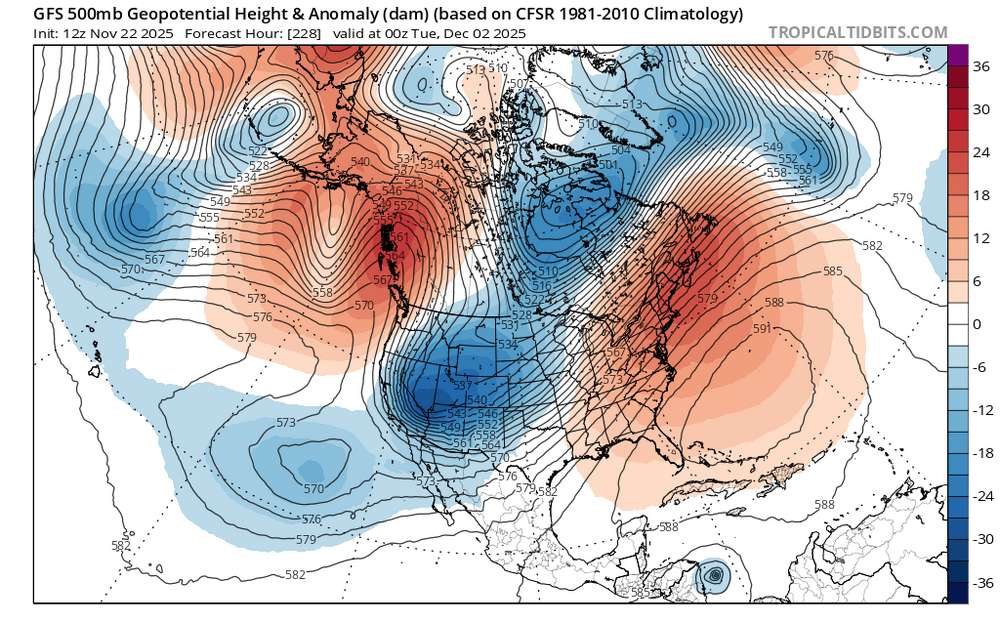
12z suites showing a big cold dump in rockies, great plains & midwest with a pattern very early DEC 2013 looking. The pattern produced some ice & snow in the MW & OV as well back in 2013. Below you can click the link & watch the 2m Temp progression over that week. Underneath image you will click on "Go Forward one day": https://psl.noaa.gov/cgi-bin/data/composites/comp.day.pl?var=2m+Air+Temperature&level=Surface&iy[1]=&im[1]=&id[1]=&iy[2]=&im[2]=&id[2]=&iy[3]=&im[3]=&id[3]=&iy[4]=&im[4]=&id[4]=&iy[5]=&im[5]=&id[5]=&iy[6]=&im[6]=&id[6]=&iy[7]=&im[7]=&id[7]=&iy[8]=&im[8]=&id[8]=&iy[9]=&im[9]=&id[9]=&iy[10]=&im[10]=&id[10]=&iy[11]=&im[11]=&id[11]=&iy[12]=&im[12]=&id[12]=&iy[13]=&im[13]=&id[13]=&iy[14]=&im[14]=&id[14]=&iy[15]=&im[15]=&id[15]=&iy[16]=&im[16]=&id[16]=&iy[17]=&im[17]=&id[17]=&iy[18]=&im[18]=&id[18]=&iy[19]=&im[19]=&id[19]=&iy[20]=&im[20]=&id[20]=&monr1=12&dayr1=1&monr2=12&dayr2=1&iyr[1]=2013&filenamein=&plotlabel=&lag=0&labelc=Color&labels=Shaded&type=2&scale=&label=0&skip_vector=&cint=&lowr=&highr=&istate=0&proj=North+America&xlat1=&xlat2=&xlon1=&xlon2=&custproj=Cylindrical+Equidistant&level1=1000mb&level2=10mb&Submit=Create+Plot
-
There was another one a few years ago in December I believe, great pattern, didn’t produce. Not being a Debbie Downer, just looking at the facts.
-
and even a great pattern doesn't always produce. Look at last February.
-

November 2025 general discussions and probable topic derailings ...
CoastalWx replied to Typhoon Tip's topic in New England
Some of those spots to the south had over .4”. About .29 here. -
November 2025 general discussions and probable topic derailings ...
CoastalWx replied to Typhoon Tip's topic in New England
Brightening up here too now. Let’s go. -
November 2025 general discussions and probable topic derailings ...
CoastalWx replied to Typhoon Tip's topic in New England
These cold dumps will rip up parakeets from South America. Kevin better get ready for those plum smugglers. -

November 2025 general discussions and probable topic derailings ...
WinterWolf replied to Typhoon Tip's topic in New England
Starting to clear now..sun popping out. -
Lots of words that said nothing. People that are addicted to a certain something will attack to defend it. You protected your models well . Your sociological commentary was funny
-

2025-2026 ENSO
TheClimateChanger replied to 40/70 Benchmark's topic in Weather Forecasting and Discussion
Interesting look here. 10 warmest Novembers, minus 2009-2010 (significant ENSO mismatch) and 1913-1914 (age). Rather similar to CPC's outlook, except they are a bit more robust with the cold extension to the southeast. -
Agree that what the models show are not facts. Hopefully this year breaks favorably for us but I learned years ago not to count on the chickens too soon.
-
As a matter of fact, I received an additional 2.5 inches of snow on Feb.1 Additional 1 inch on Feb. 2 with a high of 30. The next 5 days were cold with low to mid 30's for highs. A thaw in week 2 with temps. creeping into the low 40's. Another 10 inches of snow on Feb. 24 with a high of 27. 1966 was a snowy year with 76 inches recorded.


