All Activity
- Past hour
-
Cue the creepy DIT comment.
-
 jfc, im so sick of this summer already.
 -
Gosh, maybe one of those will visit! We are do.....
-
Some nice looking members on the EPS
.thumb.png.41dc4150ad73b08e68f6bb2927baf5f3.png)
-
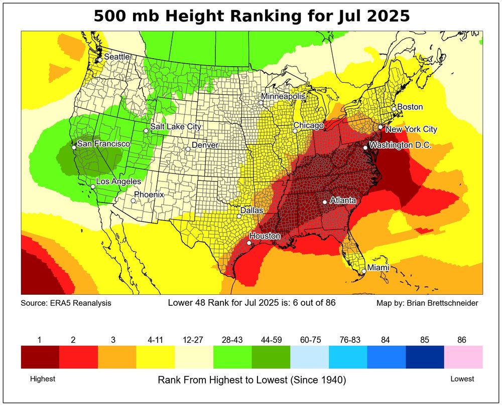
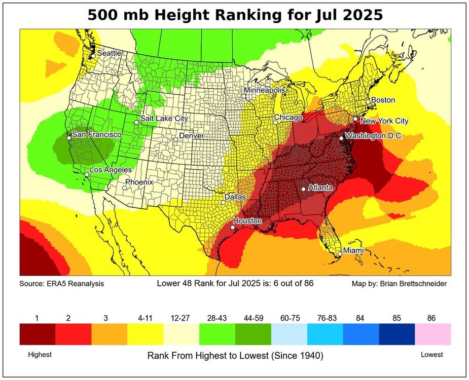
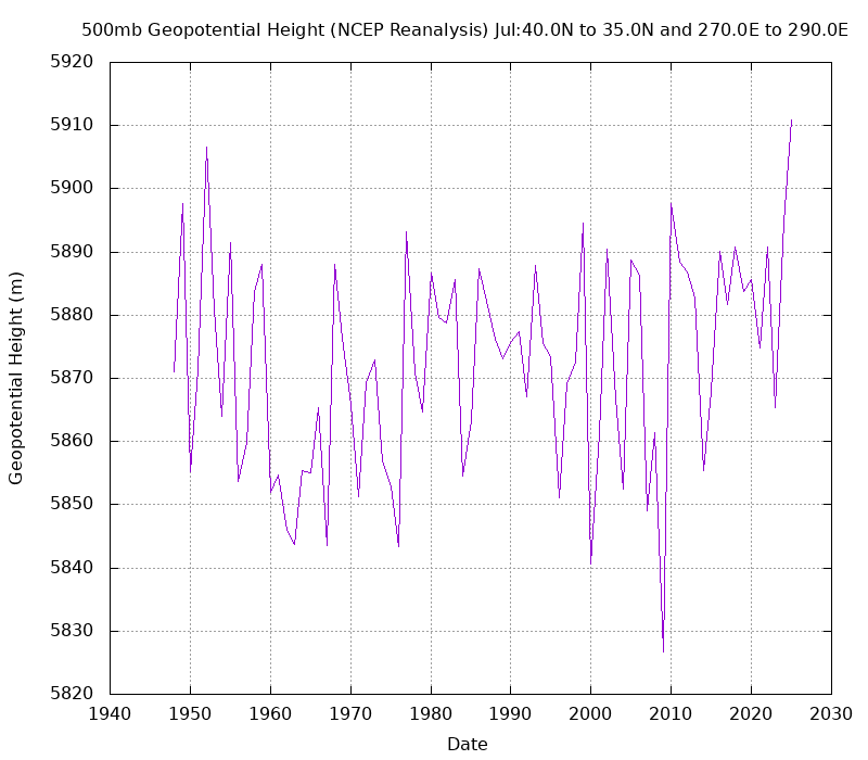
July was the strongest Southeast ridge on record for the month from NYC to ATL. This beats the previous record July 500mb heights set back in 1952. But the difference this time is that we had a +0.74 PNA for July. While July 1952 had a -1.23 PNA. So we continue to see these disconnects between the higher latitudes and mid-latitudes. This disconnect is why the Euro still has a Southeast ridge into next winter while also having a -EPO and +PNA.
-
-
$25,000 fine for using a trail system in the woods. They aren’t messing around up there.
-
Has anyone played the Shattuck in the past 10 years? Used to play it all the time until It got beat to hell. Supposedly it has recovered. Going to give it a try on Sunday.
-
I've played three of these and concur. The 10 Worst Golf Courses In America | MyGolfSpy https://share.google/rdDt9PUVEvMEr6Owf
-
https://news.novascotia.ca/en/2025/08/05/travel-activities-woods-restricted-prevent-wildfires?fbclid=IwQ0xDSwMBY_xleHRuA2FlbQIxMQABHrwJuYXtz01GIFhzMDl6tRQmO9qPIkhim2efdptit4YSQShQ2uedQmTBUGoF_aem_Os-YHBNtStld8HXYamK1nQ
-
 Not according to the models, perhaps, but the system to our south was close enough to be a possible "player". Future radar was showing that a few showers would be able to penetrate the blocking high.
 -
Gonna be in mexico city for a couple weeks so hope I don't miss too much action. monsoon season down there with highs in mid 70s and daily afternoon pop up storms, which sounds perfecto
-
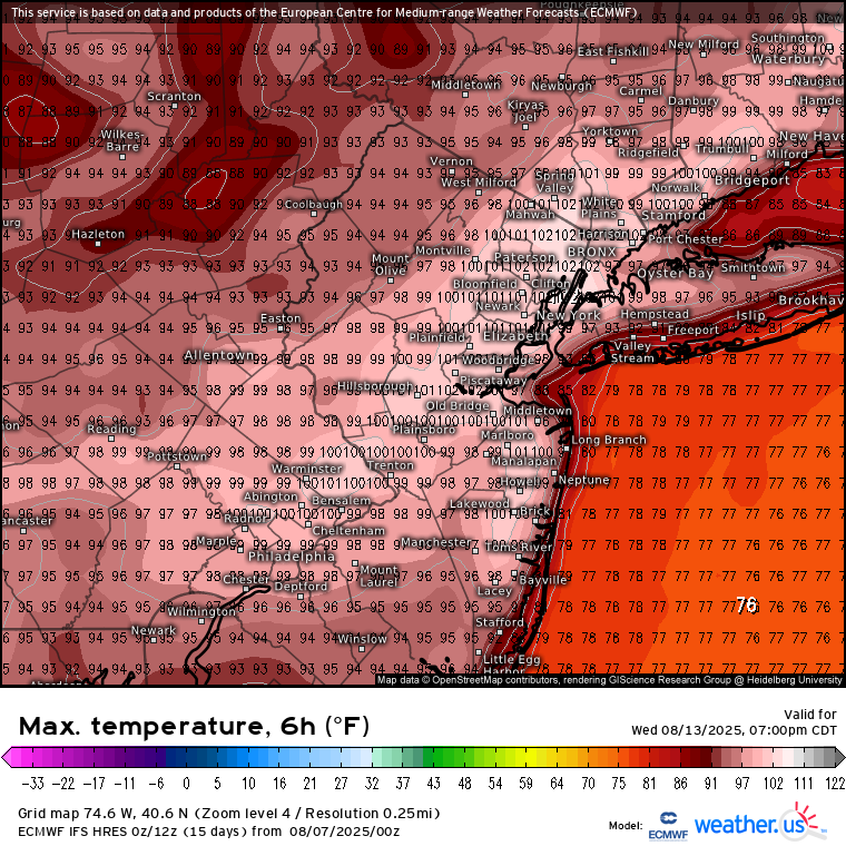
 Yeah, the Euro has all-time mid-August heat in the forecast. Just using Newark as a reference point, it gets places like Newark to 102°. That ties for the warmest ever recorded for this time of year. You can also see that Central to Northern Queens could reach 100°. Time Series Summary for NEWARK LIBERTY INTL AP, NJ Highest Temperatures August 11th through 20th Click column heading to sort ascending, click again to sort descending. 1 2005-08-20 102 0 - 1949-08-20 102 0 - 1944-08-20 102 0 2 2002-08-20 100 0
-
Such a drought in Nova Scotia they’re fining people if they go into the woods? Is this true? Where’s @Hazey
- Today
-
Despite the great patterns for retaining arctic sea ice, here we sit with this:
-
58 degrees for the low this morning. Picked .03” off of a stray shower yesterday afternoon. Had 5 bucks in my back yard last evening, just passing trough.
-
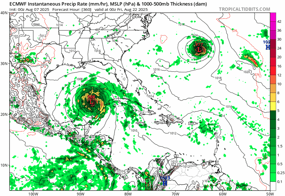
Euro hour 360, just saying that crazy GFS hour 384 image has model support...
-

2025 Atlantic Hurricane Season
TheDreamTraveler replied to BarryStantonGBP's topic in Tropical Headquarters
They're not saying that we're going to get massive hurricanes just that the models are showing an active signal coming up which usually means we'll see some storms form somewhere. The models showing so many consistently big hurricanes is a good sign we're about to enter an active period for a bit. -
Anyone calling the rapid climate change we’re seeing “minor warming” like you did, is probably a bit daft. Sorry…but there comes a point when if you can’t see reality for what it is, maybe you should spend your time doing something other than constantly posting in this thread.
-
2025 ACE, which is now 3.5, has just moved ahead of both 1998 and 1999 as of this date. Neither of those years had another storm til Aug 18/19. And yet they each ended up with ACE of 181 and 176, respectively.
-
Dude. The GFS showed us 40 inch blizzards all winter and now its showing us massive hurricanes hitting everywhere all at once. Someone has to be messing with it. I trust the JMA more than the 384 hour GFS.
-
Had no clue that there was even any rain here. I have stopped looking at radar lately.
-
I'm sure it's entirely coincidence, but we are hitting the 30 year legendary/epic winter cycle year here in 25-26. The winters of 1935-36, 1965-66, and 1995-96 were all given to stretches of very abnormal cold/ above average snowfall. I know in 1935-36 the NE Pacific was on fire, 3c AN. Western areas did the worst in that winter, but Memphis still got over 10 inches of snow Dec-Feb. Nashville got 19.2 inches from 4 big events. Knoxville had 28 inches that winter. Chattanooga had around 21 inches that winter. My area had 39 inches that winter. 12 in December, 9 in January, and 18 in February. The North Pac was also warm in 1965-1966. January of 66 was absolutely one of our harshest winter events. Most of the state was 5 to 20 below zero after a few big snow events. Alabama set their all time state record low then, when a small town NE of Huntsville hit -27. 1995-95 delivered epic winter here but the north pacific was cool that season. I'm sure a coincidence but an odd one. As for Carver's question about general sst vs blocking, I've found that is a loose correlation at times, mainly even when we get favorable sst in a region that would normally promote blocking, we often still don't get it. I'll look into La Nada winters but I believe enso neutral leans towards AN temps as a rule.
-
It's also much easier to get warm with fire and cloths and shelter than it is to cool off when off the grid like a lot of the world's population.
-
 Nice and cool out


.png.9a7b007ad9170dc8180430760c260a50.png)