All Activity
- Past hour
-
Thanks, Chris. It still was a 6 day long phase 8 last January (Jan 7-12) that peaked at a decent amplitude of 2.1. I consider that near an average length phase 8 in January rather than brief. Phase 8’s 6 days was as long or longer than any other phase last January as it went around to phase 4. Granted, the average amplitude of the 6 days in phase 8 wasn’t nearly as high as that of phases 1-4, which were closer to 2 and thus not it wasn’t as pronounced an amplitude as those as you said, but it still averaged ~1.3, a moderate phase 8. I consider weak to be <1, moderate 1-2, and strong 2+. So, I have it as an avg length near avg amplitude phase 8 during last Jan.
-
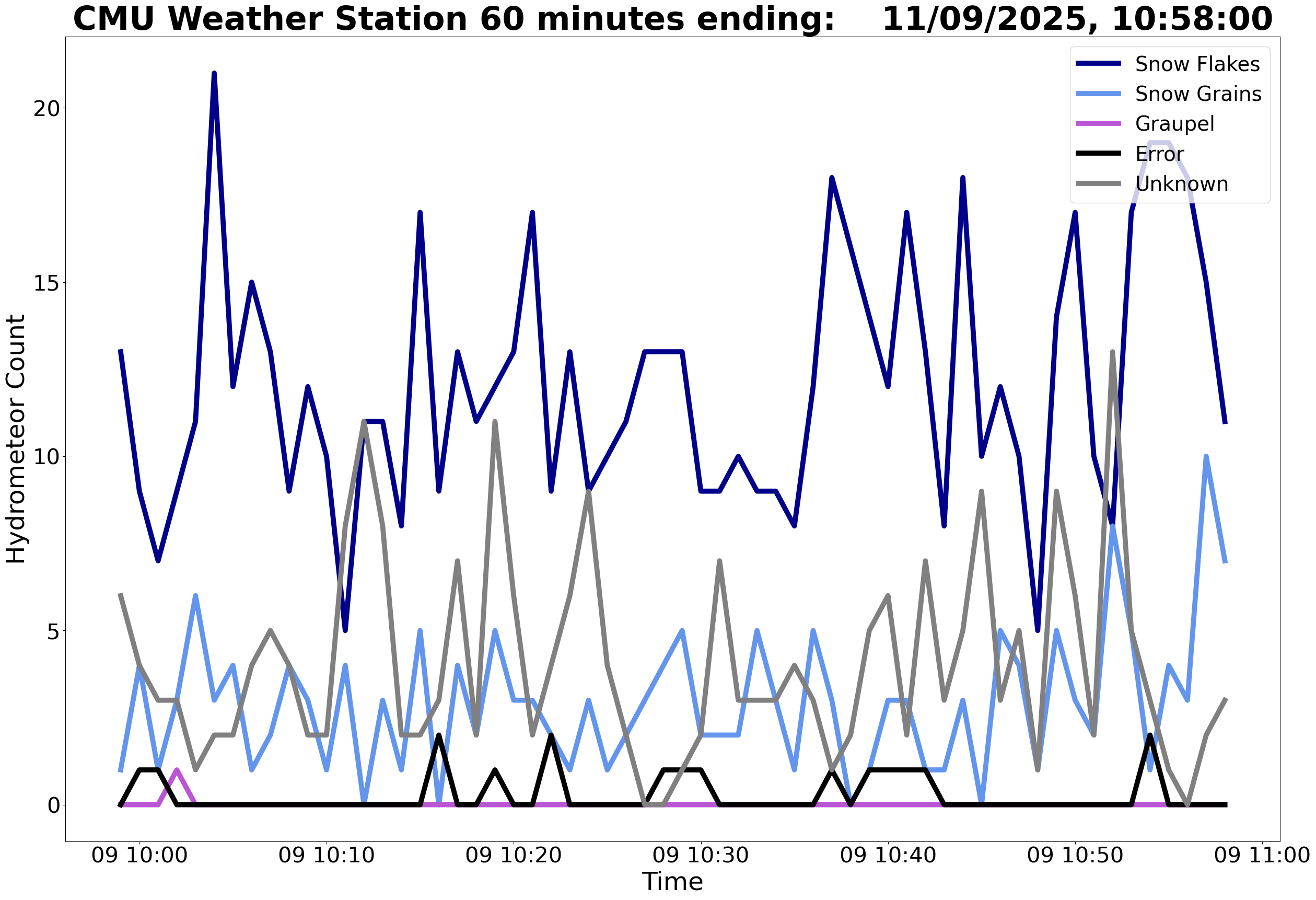
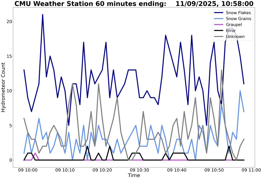
It’s all lake effect
-
I've been occasionally browsing these myself. Nice of him to provide an explanation here of how it works/what it does/what it's doing.
-
Nice downpour happening.
-
happy for you all in the lake effect bands, grass is partially covered here, and we've had some steady flakes over the past hour.
-
 63F
63F -
-
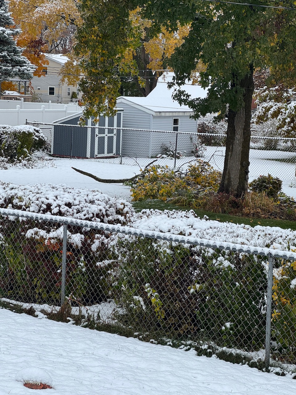
I did the same. As I am looking out the window its ripping fatties(oak leaves) and covering up the area I just cleared.
-
Yeah, the Great Lakes have been getting the heaviest snows with all these cutter and hugger storm tracks in recent years.
-

11/8-11/10 First Snow and Lake Effect Event
migratingwx replied to Geoboy645's topic in Lakes/Ohio Valley
I'm in River North. I moved to Chicago back in the spring and never thought I'd see LES of this magnitude. Looking forward to experiencing this. -
RAH talks about the chance of a brief period of snow tomorrow night in latest discussion
-
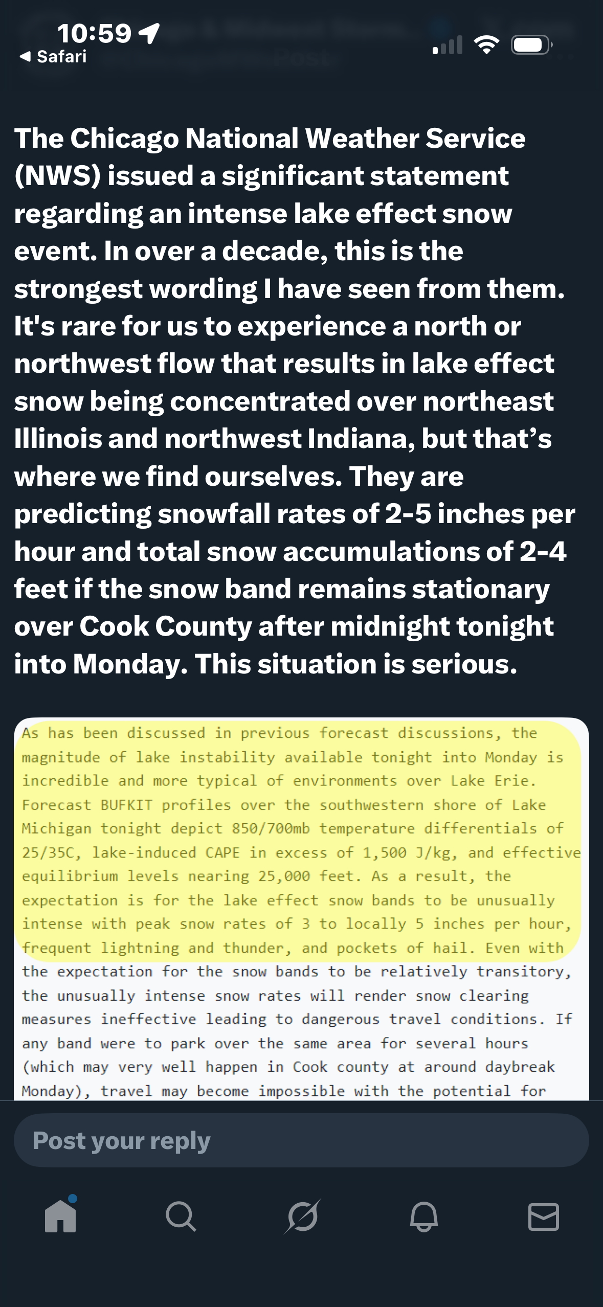
Crazy for so early in the season Including the cities of Chicago, Peotone, Northbrook, Crete, Evanston, Lemont, Park Forest, Schaumburg, Cicero, Oak Park, La Grange, Des Plaines, Oak Forest, Oak Lawn, Calumet City, Beecher, Palatine, and Orland Park 224 AM CST Sun Nov 9 2025 ...WINTER STORM WARNING IN EFFECT FROM 9 PM THIS EVENING TO NOON CST MONDAY... * WHAT...Dangerous to impossible travel conditions due to intense lake effect snow expected. Snow rates in excess of 3 inches per hour, localized total snow accumulations of 12 to 18 inches, and northerly wind gusts in excess of 30 mph are expected.
-
 https://twitter.com/chicagomweather/status/1987519067641594002?s=46&t=dhcbvkjmRcyBVQtDxJ3lRg
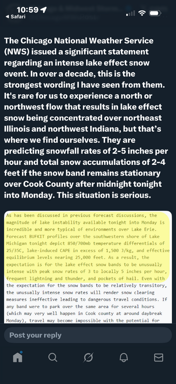
-

Central PA Fall Discussions and Obs
Mount Joy Snowman replied to ChescoWx's topic in Upstate New York/Pennsylvania
Looks like I’m up near three quarters of an inch already. Was not expecting nearly this much. -

Central PA Fall Discussions and Obs
canderson replied to ChescoWx's topic in Upstate New York/Pennsylvania
Sun is poking out in Manhattan. Hope the rain here is just light …. -

November 2025 general discussions and probable topic derailings ...
Lava Rock replied to Typhoon Tip's topic in New England
Wintert appeal north conway Sent from my SM-S921U using Tapatalk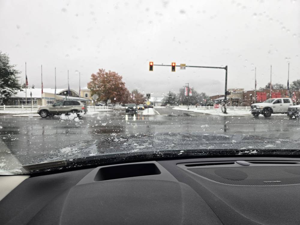
-
The conversational flurries seem to want to go south to Richmond. When have we heard that story before...
-

November 2025 general discussions and probable topic derailings ...
dendrite replied to Typhoon Tip's topic in New England
That’s an aggressive forecast. -

11/8-11/10 First Snow and Lake Effect Event
sbnwx85 replied to Geoboy645's topic in Lakes/Ohio Valley
Just 1.5” took out a good-size tree limb next door.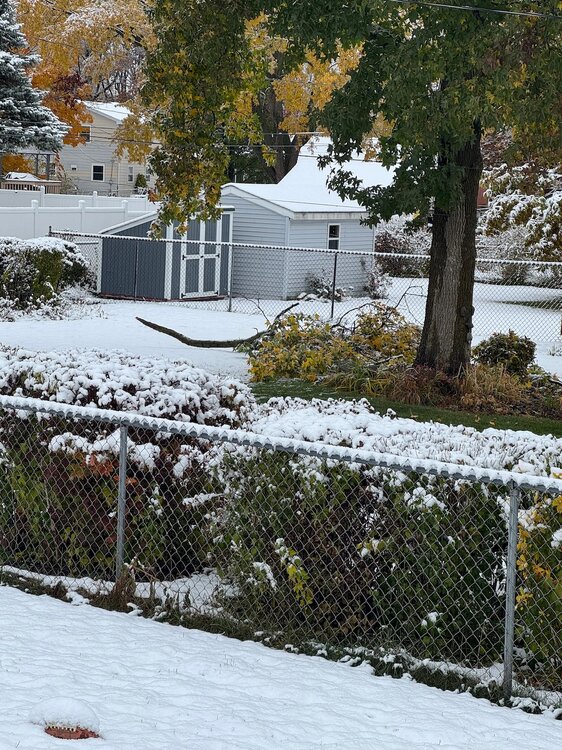
-

November 2025 general discussions and probable topic derailings ...
powderfreak replied to Typhoon Tip's topic in New England
That’s pretty impressive. -
https://x.com/nilwxreports/status/1987487965044424771?s=46&t=dhcbvkjmRcyBVQtDxJ3lRg
-

11/8-11/10 First Snow and Lake Effect Event
cyclone77 replied to Geoboy645's topic in Lakes/Ohio Valley
On the board with 0.3" here. Looks nice with the trees still colorful. Looking forward to watching how this LE monster evolves tonight. -
They’re talking 3-6 per hour with TSSN
-

November 2025 general discussions and probable topic derailings ...
CoastalWx replied to Typhoon Tip's topic in New England
lol maybe a few inches -

Central PA Fall Discussions and Obs
Itstrainingtime replied to ChescoWx's topic in Upstate New York/Pennsylvania
0.54" from that storm.


.thumb.jpg.ad3a2e31d30aff035044689b311a0540.jpg)