All Activity
- Past hour
-
Battle of PA in the first round, Montreal/Tampa, Dallas/Minnesota too. It's going to be a fun playoffs.
-
Made it up to 84 currently 74
-

2026-2027 El Nino
PhiEaglesfan712 replied to Stormchaserchuck1's topic in Weather Forecasting and Discussion
2015 and 2023 didn't really have that swing. We got borderline cold neutrals/weak la ninas out of those. The 1972-73, 1986-88, 1997-98, and 2009-10 events had the big swing going immediately from strong el nino -> strong la nina. The other way, it doesn't go strong la nina -> strong el nino right away. It seems at least one year is needed in between to make the transition. The closest is 1955-56 strong la nina -> 1957-58 strong el nino and 2007-08 strong la nina -> 2009-10 strong el nino (and that one of course was a quick transition back to strong la nina in 2010-11). -
I’ve dented a cup and lipped out a couple times. Haven’t scared the hole in a couple years though.
-
What does it take these days to get a Moderate risk? Doesn't make sense given the watch probabilities?
-
Ambrose jet starting to kick in. JFK down to 71 gusting to 26 out of the south. Should continue to increase. .
- 455 replies
-
- 1
-

-
- april showers bring may..
- rain
- (and 2 more)
-
Trying to resist the urge to turn on the ac
-
 Hi all (mods, if you need to move this to marketplace, I understand. I was just hoping it wouldn't be buried there) I am looking for input from mets and serious hobbyists about the tools they use to share their analysis and forecasts outside of here (blogs, personal sites, social media, newsletters, or anywhere else). --> TL;DR: I am building a weather platform / app and want to onboard early adopters interested in expanding their reach. I put together a short survey to make sure I'm building the right tools. What I'm building: A weather app and publishing platform with two goals: For the public: highly personalized, hype-free weather guidance with real medium-range risk information. The target is people who need clearer guidance to make real decisions about their property, their businesses, their week. For forecasters: a dedicated place to publish analysis that reaches a broader audience, with tools built specifically for weather content — mapping, accuracy tracking, subscriber relationships — instead of fighting general-purpose blog tools and social media algorithms. I believe the best weather analysis is being produced by independent forecasters, and that most of it never reaches the people who would benefit from it. The platforms that do reach general audiences reward sensationalism over substance. I am trying to build something better. What I would love to have from you: A 3-minute survey about your current tools, what's working, what's not, and which features would make a difference: https://docs.google.com/forms/d/e/1FAIpQLSe39_X8KXighPxN8Ln9RnRv0-saecn_hcylihb_aaCVGokkEQ/viewform?usp=header If you're interested in early access and helping to test out the tools, there's an optional section at the end to leave your info. I'll share results back here. Thanks! Jeff
 -
Nice outside. Too warm inside. A/C turned on for first time this season on second floor. With sun pouring in the temperature up there was 78 degrees. No thanks. Still cool on the main floor 73 degrees. A very comfortable 68 degrees down in the Man Cave. Pollen season underway with green dust building up on everything. Another reason to keep the windows closed. Beautiful outside though. Low humidity, a nice breeze and temperature 84 down from a high 85. Will be watering the grass seed again this evening. Could use some rain.
-
Seabreeze through here. Kicked wind up. Cooled temps off a tiny bit.
-
It looks like it's about to rotate a bunch.
-
NAM had Islip at 71. It hit 78. It stinks
- 455 replies
-
- 1
-
-
- april showers bring may..
- rain
- (and 2 more)
-
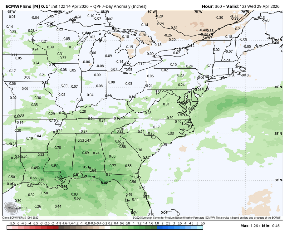
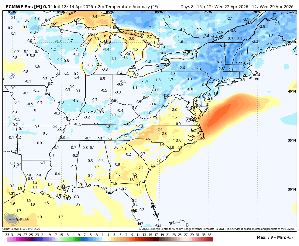
WB 12Z EPS...hopefully the wetter and cooler forecast for late April will verify!

-
-
82/60
-
That Iowa cell already looks like its producing massive hail.
- Today
-
85
-
We are well inside the tornado watch, but models are mostly keeping the storms north of Cedar Rapids.
-
SPC should’ve just included NE IL in that watch; it’s just gonna be extended eventually.
-
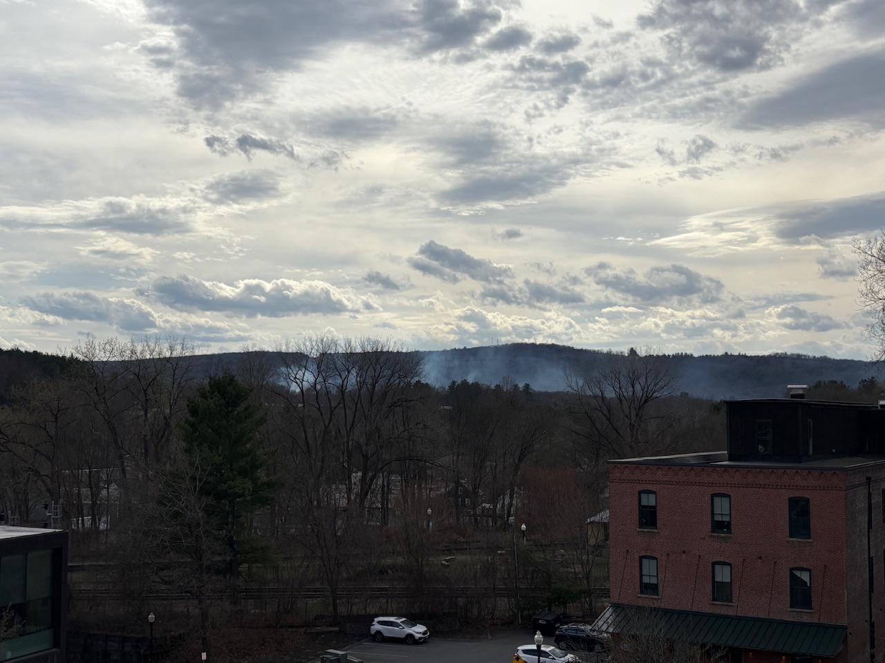
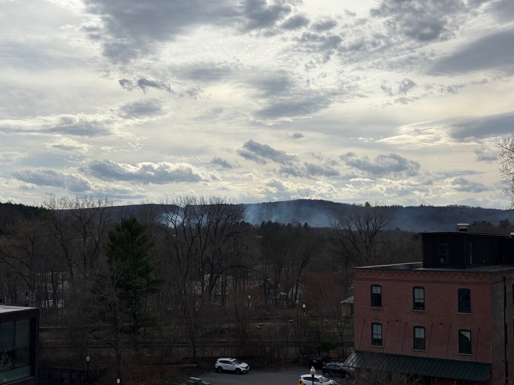
Three alarm brushfire now in Greenfield.
-
Nice big watch box now. Some strong-ish language… Tornado Watch for portions of Central and Eastern lowa Northern Illinois Extreme Southeast Minnesota Southern Wisconsin Lake Michigan Effective this Tuesday afternoon and evening from 230 PM until 1000 PM CDT. Primary threats include... Several tornadoes and a couple intense tornadoes likely Widespread large hail and scattered very large hail events to 4 inches in diameter likely Scattered damaging winds likely with isolated significant gusts to 75 mph possible SUMMARY...Supercell thunderstorms will pose a threat for very large to giant hail this afternoon and evening as they track eastward, with the largest hailstones potentially reaching up to 3-4 inches in diameter. The threat for several tornadoes will increase later this afternoon and evening along a warm front, and any sustained supercell will be capable of producing a strong tornado. Otherwise, scattered to numerous severe/damaging winds may eventually occur as thunderstorms consolidate into one or more bowing clusters, with peak gusts up to 65-75 mph.
-
After a low of 51, got ot 86 as a high, 84 now.
-
86/54
-
I'll gladly switch
-
83 earlier, dropped back to 79 now. Summah!!


.thumb.png.4150b06c63a21f61052e47a612bf1818.png)