All Activity
- Past hour
-
Yes, THAT is how we win and its inside an established pattern. Not a wave breaking into something as we're setting up. Really would like to see at least a slightly -NAO to help lock in our cold air though.
-

December 2025 regional war/obs/disco thread
Damage In Tolland replied to Torch Tiger's topic in New England
Scooter knows -
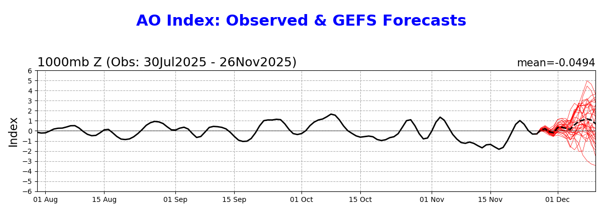
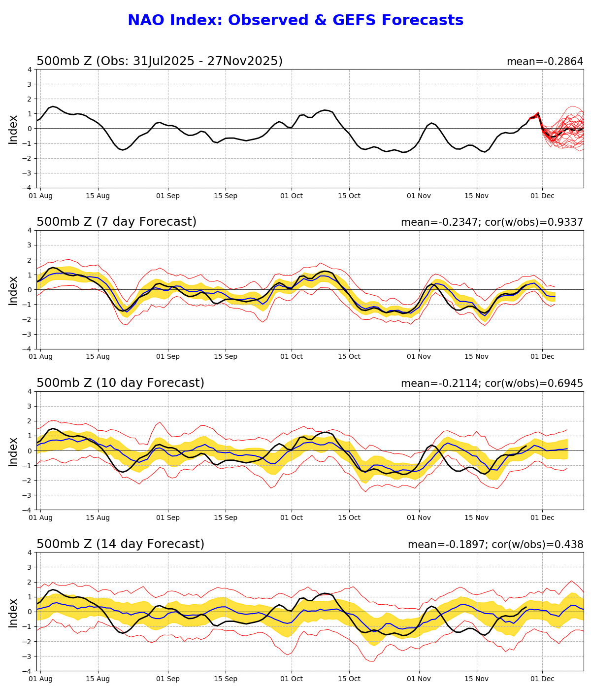
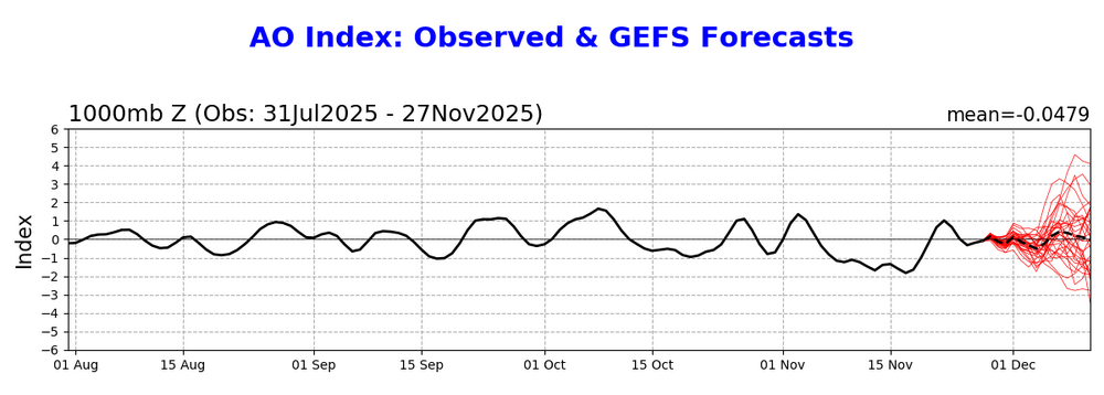
And here’s even more good trends vs yesterday for cold lovers: Yesterday’s (11/26) GEFS AO through 12/10: rose to solid +AO of +1: Today’s (11/27) GEFS AO: neutral/near 0:

-
Like warm fronts, that pride front ripped through Tolland first.
-
Albany looks like the jackpot. I think this is a north of I84 storm. Hopefully coastal plain can cash in at some point in Dec..
-

Nov 28-30th Post Turkey Day Wintry Potential
mimillman replied to Chicago Storm's topic in Lakes/Ohio Valley
Buddy, it’s a joke. Pretty sure he knows it as I made the same joke about 3 years ago -

December 2025 regional war/obs/disco thread
TauntonBlizzard2013 replied to Torch Tiger's topic in New England
The 6z euro is probably best case here. Everything else is a mess south of pike -

Nov 28-30th Post Turkey Day Wintry Potential
beavis1729 replied to Chicago Storm's topic in Lakes/Ohio Valley
So? No need to be a jerk…Jerry is in town for the week and hoping for the best outcome like all of us. -
more likely
-

Add your Snowfall predictions 25/26 winter
moneypitmike replied to Ginx snewx's topic in New England
Bath ME 82 Mattepoisett 7 -
That was a perfect set up. Cold High anchored NW of us in Canada and a huge slug of moisture running Sw to NE. As the run ended we had 6"+ on the ground and several panels of snow left to go past 240 hours. North of DC would of been easily 12+ amounts.
-
This reads as though there could be a dramatic, 300-esque movie historical significance to it but I fear I may be misinterpreting this particular “Roman helmet”…
-
Snow flurries
-
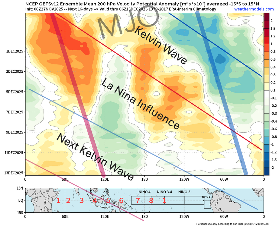
I made some quick markups on the chart from the 6Z GEFS to better illustrate what you're seeing on those charts. This ties in to the post I made a couple of days ago regarding kelvin waves and the mjo signal. The true Phase 8 attempt will be right near mid month. Just out of range still but closing in. Effectiveness remains to be seen of course. Notice on this also how the la nina influence re-emerges in between passing kelvin waves causing the loops on those charts.
-
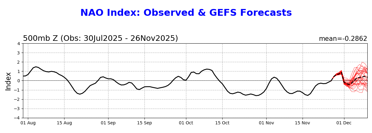
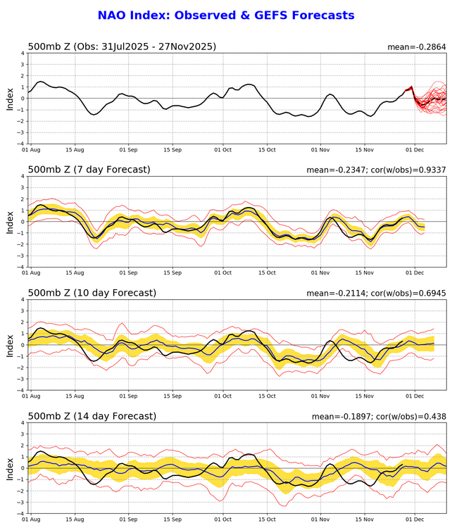
If the more favorable phase 8 progs today vs yesterday are not enough good news for those who prefer it cold in the E US, I’ve got more: Yesterday’s (11/26) GEFS NAO through 12/10: headed to moderate +NAO Today’s (11/27) GEFS NAO through 12/11: no +NAO as it stops rising at dead neutral (0):

-

E PA/NJ/DE Autumn 2025 Obs/Discussion
penndotguy replied to PhiEaglesfan712's topic in Philadelphia Region
Agree I think 3 days out from the potential is reasonable, we in this zone have been burned so often even in the 3 day window. My thinking is wait till the event is in the US so the guidance can better pickup on the atmosphere. -
 jumpinjackflash joined the community
 -
Give me the set up at the end of the Can run last night. Endless overrunning into a stout HP. I think these set ups only occur on model runs though.
-

Nov 28-30th Post Turkey Day Wintry Potential
Stevo6899 replied to Chicago Storm's topic in Lakes/Ohio Valley
tbh I dont see much accumulating here. -
Likely picking up on some of that CAD ice potential
-
I’m not saying they won’t and it’s very possible we see a full scale shift next year with the Nino. My point is that the cooling you are seeing right now is due to the very persistent and strong convection, which is to be expected with the standing wave there. Although they have cooled, there are still anomalies of +30C, which is why the convection is there in the first place, the atmosphere always places it over the warmest waters due to evaporation and latent/sensible heat release
-
December 2025 regional war/obs/disco thread
moneypitmike replied to Torch Tiger's topic in New England
They've already been typing for two hours. -
December 2025 regional war/obs/disco thread
Damage In Tolland replied to Torch Tiger's topic in New England
Like a Roman helmet about to drop on Scooter’s face -

Central PA Fall Discussions and Obs
anotherman replied to ChescoWx's topic in Upstate New York/Pennsylvania
It snowed on Thanksgiving eve in 2014. -
Why wouldn't they continue to cool? Through history all sections of the pacific have had warming and cooling trends.
-
(002).thumb.png.6e3d9d46bca5fe41aab7a74871dd8af8.png)
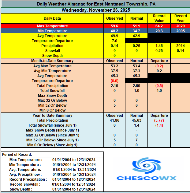
E PA/NJ/DE Autumn 2025 Obs/Discussion
ChescoWx replied to PhiEaglesfan712's topic in Philadelphia Region
Happy Thanksgiving to all of you! With the passage of last night’s cold front, we will now see a sustained period of colder than normal temperatures. Of note November will finish as another below normal temperature month. This will be the 3rd below average temperature month over the last 4 months with only September finishing with above average temperatures. Today looks mostly cloudy and breezy with the sun returning tomorrow and Saturday. Rain arrives by Sunday afternoon and ends in the evening. We then see a chance of snow arriving by Tuesday morning before it is likely to turn to rain from south to north during the day Tuesday.