All Activity
- Past hour
-
December into early January is hurting my grade here missing out. We had the pattern too. On the other hand I can’t hate the two massive events and consistent cold and decent pack. But need a half decent march to really lock in an A.
-
Still need to see more cross guidance agreement, but NAM/GFS kind of remind me of the 1/17 advisory event that really popped up out of nowhere within 72 hours or so
-
Who cares about roads
-

Outta gas and Outta Time: Early March Winter Storm finale
Bob Chill replied to Ji's topic in Mid Atlantic
Upper levels have looked pretty blah on this one since the beginning. I agree with Wes about the overcooked potential and that's why I've been quiet. It's just not adding up for a 6" snowfall anywhere. Weak sauce won't do it with surface temps so I've been leaning towards SnowTV at best and I also don't think it ends up hitting my yard. Central VA thru the DMV is the most likely area to see any snow falling. If I only saw this panel on the GFS I would never think a 6" snowfall would be the outcome. I would think a swath of scattered light precip and not a shield that drops .5+qpf. All that said, models haven't locked into the strength of the shortwave and it definitely bears watching for accum snow for someone. The setup with the HP pressing into the precip is much better than HP running away. With enough lift pushing against a modest shortwave it can maximize potential in narrow stripe.
-
But Bernie thinks snow will reach all of New England - this is from this morning
-
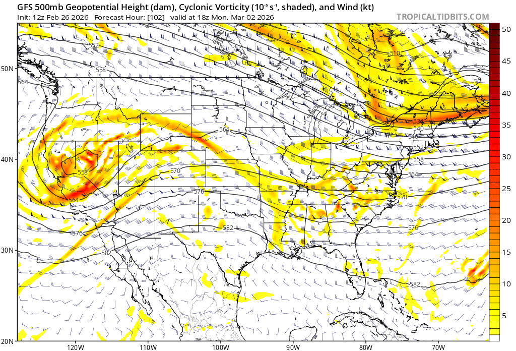
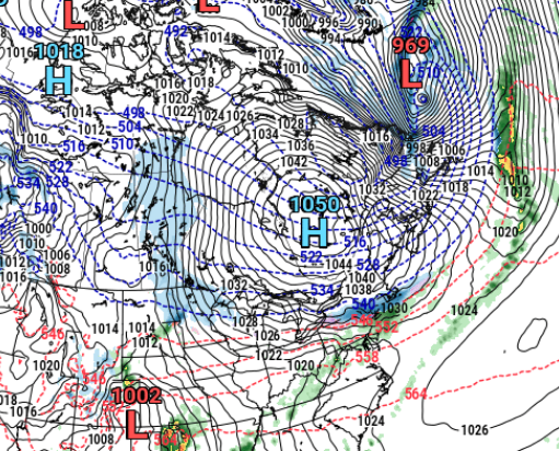
To Will's point from earlier check out the 12z GFS's eastern Canada high 1050!
-
I know I'm probably an outlier, but I always hope it's cold or cool as long as possible. I really enjoy spring, once it's proper spring. But forecast warmth now is still a drag for me. Idgaf about shorts and tshirts. Lawn care can wait as long as possible. I'll allow that warmer hikes are mildly appealing. March is a terrible month. The worst. A few torches in it doesn't make it better. All you bring on spring weenies, I get you, your warmth cravings are normal, I'm just not like that.
-
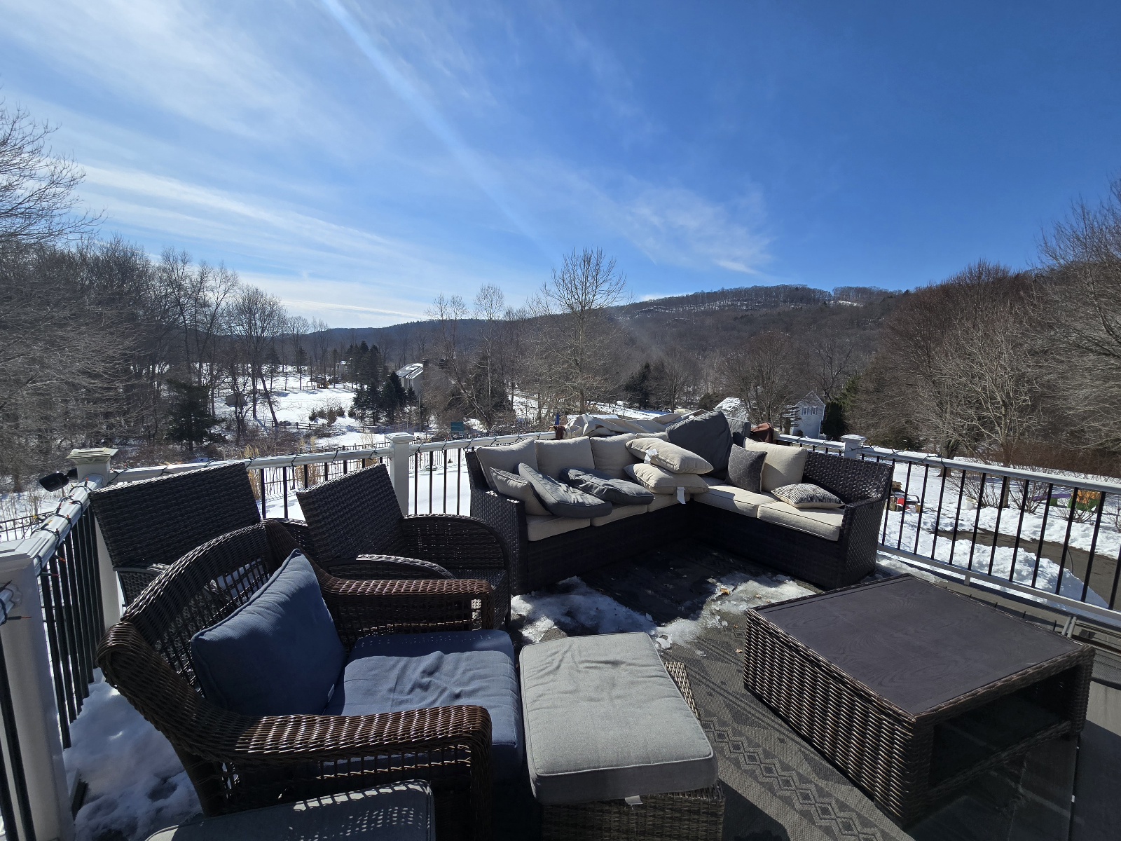
Almost 45 here under full sun, south facing porch ftw...kids were out here sunning until the 12 inches of snow starting shifting off the panels up above
-
Cmc was north but shreds the precip. Ukie has no 2nd wave.
-
We get these types of events heading into spring where the wavelengths change and events crank up as you get closer in . Reminds me of one of those that starts innocent and before you know it models ramp up each run to like 4-8” deal
-
I know an alternate source of hot air.
-
@Terpeast @WxUSAF Was the Palm Sunday blizzard of 1942 one of the HECS storms that would likely not have happened today? I know when this was a topic and that regression study was done Feb 1987 was a lost one and one other was mentioned, was it 1942? Baltimore got 22" but the temperature never got below 33 degrees the whole storm. Seems unlikely that would have worked out today with the roughly 3.5F increase in temps since then. That's kinda depressing...one of Baltimores biggest snowstorms ever would probably just have been a dismal rainy spring day if that same exact thing happened again today.
-

Central PA Winter 25/26 Discussion and Obs
Itstrainingtime replied to MAG5035's topic in Upstate New York/Pennsylvania
"Feels" like spring is imminent based on the vibe of the thread. Posts are slowing down noticeably. TBD if we get something later in March. -

February 2026 OBS & Discussion
boxingdayblizzard replied to Stormlover74's topic in New York City Metro
It’s amazing how quickly it’s going this time of year. I think that because it’s melting quicker and everyone forgets the high totals that fell people are thinking this past storm doesn’t compare to events like ‘96 or Boxing Day -
If Sunday happens I’ll be up over 70. Something I never thought possible this winter . It gets an A for a grade even if it ended today . Frequent small events .Check.. couple big uns.. check.. pack almost all winter.. check .. a wintry holiday period . Check.. persistent cold .. check . No torches .. check. A winter that started in Nov and continued almost unabated except a few days in Jan…. Check . Just like the 70’s that i remember The only thing missing was a big ice storm
-

Richmond Metro/Hampton Roads Area Discussion
wasnow215 replied to RIC Airport's topic in Mid Atlantic
Just one model run but it shows SNOWDEPTH several inches of snow -
Does have a little critter vibe about it
-
I'm over 50" for the first time since I moved back in 2018. I'm loving it.
-

Outta gas and Outta Time: Early March Winter Storm finale
87storms replied to Ji's topic in Mid Atlantic
The bias/variance trade-off in ML is probably one of the most important things anyone can learn when building models. I imagine it’s even more of a factor as model resolution improves and training sets get larger. Would be an interesting topic to explore. -
This could go back to meh, and the GFS just had a pretty ugly loss in trying to get snow into SNE tonight, but you can kind of see the signal grow for something minor across guidance. Need Euro to get back on board.
-
It’s like we’re holding hands , just walking thru the snow
-
Kev, we've been agreeing a lot this winter. It feels...good.
-

Late February/Early March 2026 Mid-Long Range
JenkinsJinkies replied to WxUSAF's topic in Mid Atlantic
Could the dry pattern finally be breaking? -
45 / 19 40s today / Friday, 50s on Saturday. Down the roller coaster starting Sunday and through next Friday before moderation to perhaps a stronger warm up similar to the Jan 6 - Jan 14. Tracking risks Mon - Wed or perhaps even Sunday.
-
Yes, take the one that's actually showing up on the models over us at shorter range. Much like the "event" the models had for tonight/Friday--they can go poof fast.