All Activity
- Past hour
-
Nice! Get after it
-
Hail in McLean
-
We want tropical
-
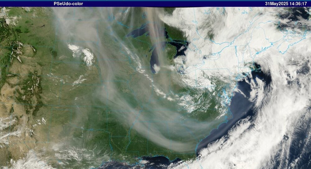
Looks like our old friend- Canadian wildfire smoke- is back
-
This May seems to have been the coolest, cloudiest, and wettest I can remember of late. I live a little over a mile as the crow flies from the Rhode Island shore so I expect a cool spring. But this May my solar panel power production is significantly lower than the past four Mays. It's 28% lower than my previous high in 2023, and 15% lower than my previous low in 2021. There's almost 8-inches of rain in my rain guage. If flowers are any indication, based on last years photos, my wife's perennial gardens are behind last May. Here's hoping June breaks the spell.
-
Says 66 but feels way colder. Keep getting rain spurts too.
-
My final in Wantage for the 11 hour rain event 2.03 ending 11A. Fits NJ climate data as well as NYS Mesonet.By the way that is .23 LESS than the automated AWN... tips too much in heavy rain.
-
Maybe not in the country but different in the city... less relief! I think departures are important, be it night or day. We need to continue reviewing.
-
I like it cool but the rain can GTFO its even getting old to me lol
-
Everything looks sub-severe so far - probably will intensify a bit as it nears/gets east of I-95.
-
A steady synoptic rain at 59F throughout the entire daylight hours of a Saturday. Just how @ineedsnow would draw it up.
-
12z Icon has mid 90s for some Thursday.. looks like I'll be wrong and we roast for a few days then we get back closer to normal
-
-
It's pretty cold here with this wind even with sunshine, tomorrow likely to be the same.
-
It went from nice (nearly epic alert level) to cloudy/rainy quickly here in Baker Park and windy. Is it summer yet?
-

2025-2026 ENSO
michsnowfreak replied to 40/70 Benchmark's topic in Weather Forecasting and Discussion
We are not in a completely different climate than we were in 2010. -
Cool and breezy. Another Fall like day to end May.
- Today
-
pushing 1.4" here and coming down at a good clip atm. nearing 9" for the month
-
Storms beginning to fire up near Hagerstown and North of State College. All moving SE .
-
Still nasty smoke plume rotating southeast out of Canada. For the most part it is rotating under us today around base of trof / upper level low. As that lifts out we will likely see some affects from it tomorrow and Monday but bulk of it will be directed south and then east so mainly to our south.
-
Sure is. What a captivating image of the present storm system departing and the Manitoba smoke all interacting.
-
Getting a gusty shower with the temp falling to 60°. Doesn’t feel like June is a day away. 0.90” from yesterday which pushed me above 9.00” for the month.
-
https://www.weather.gov/wrh/TextProduct?product=pnsphi Latest rainfall numbers from latest PNS out of PHI.
-
My brother in Sussex County also said there’s localized flooding near Franklin.
-
It’s windy. 35 mph stuff


