All Activity
- Past hour
-
Impressive thunderstorm just starting here, been thundering for 15 minutes as it moved in.
-
Yea, good soaking rain up here. Looks like 1.5”+ for the day is within reach
-
Quite a bit of lightning with the activity to the SW of CHO.
-
Maue advocating for continued fossil fuel use to preemptively avert the cooling associated with *3* Tambora-level eruptions in the 2050s just in case
-
1.52 perfect type of rain
-
Impressive rainfall queueing up just SE of Crozet, VA. Looks like it's aimed right at the mountains again.
-
1.08” with this last batch pushing through.
-
wow earliest shark sighting on Long Island, a Great White was sighted near Montauk!!
-

E PA/NJ/DE Spring 2025 Obs/Discussion
RedSky replied to PhiEaglesfan712's topic in Philadelphia Region
.30" ECM projecting 4" through day 15 DT says it's going to be cutoff hell forever It sucks - Today
-
Eastern Columbia 4pm 1.07” with drizzle.
-
OKX is in clear air mode, that's why. If they switched to precip mode would be a lot closer to reality of producing not much.
-
Frostburg Reservoir at 2500’ elevation in western Maryland reporting 5.64” since midnight.
-
not here, not even a drop. ground is completely dry.
-
0.69" so far in my neighborhood. About to head home from work. Hopefully pick up a nice dousing overnight.
-

E PA/NJ/DE Spring 2025 Obs/Discussion
BBasile replied to PhiEaglesfan712's topic in Philadelphia Region
Up to 0.17" now. I'll take it. 65.6F -
Is all that stuff on radar that looks a lot more dramatic than it really is producing anything anywhere?
-
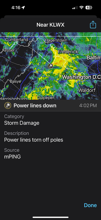
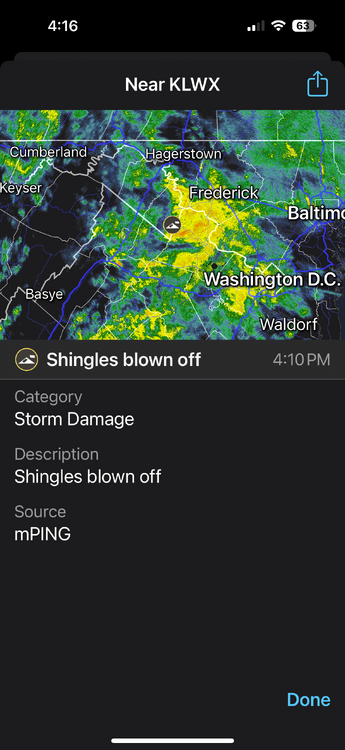
Anyone seen these two mPING Reports
-
Impressive photos emerging from western Maryland.
-
Showers and thundershowers are likely this evening into tomorrow. It will turn somewhat warmer on Thursday and the week could end with temperatures in the upper 70s to perhaps 80°. Meanwhile, parts of Texas are now experiencing extreme heat. As of 3 pm CDT, daily records were surpassed in Cotulla and Del Rio and the daily record was tied in Houston. The temperature could approach or set new May monthly high temperature records in such cities as Austin, Del Rio and San Antonio tomorrow. The extended guidance has grown cooler for the second half of May than it had been. Both the CFSv2 and ECMWF weekly guidance are now in good agreement that the second half of the month could average near normal overall. The ENSO Region 1+2 anomaly was +0.1°C and the Region 3.4 anomaly was -0.1°C for the week centered around April 30. For the past six weeks, the ENSO Region 1+2 anomaly has averaged +0.68°C and the ENSO Region 3.4 anomaly has averaged -0.05°C. Neutral ENSO conditions will likely continue through at least early summer. Early indications are that summer 2025 will be warmer than normal in the New York City and Philadelphia areas. The potential exists for a much warmer than normal summer (more than 1° above normal). The SOI was +1.47 today. The preliminary Arctic Oscillation (AO) was +0.459 today. Based on sensitivity analysis applied to the latest guidance, there is an implied near 78% probability that New York City will have a warmer than normal May (1991-2020 normal). May will likely finish with a mean temperature near 65.5° (2.3° above normal).
-
Over 1.4" here so far.
-
I’ll be attending the series finale in Fenway a week from Sunday. Was hoping the rotation would stay on turn and Sugano would have that game. Tomorrow’s doubleheader is sure to mess that up.
-
Knew this was gonnabe happening: URGENT - WEATHER MESSAGE National Weather Service Austin/San Antonio TX 1253 PM CDT Tue May 13 2025 TXZ171>173-183>193-202>208-217>223-228-141000- /O.NEW.KEWX.XH.W.0001.250514T1800Z-250515T0200Z/ /O.EXT.KEWX.HT.Y.0001.250513T1800Z-250514T1800Z/ Llano-Burnet-Williamson-Val Verde-Edwards-Real-Kerr-Bandera- Gillespie-Kendall-Blanco-Hays-Travis-Bastrop-Kinney-Uvalde-Medina- Bexar-Comal-Guadalupe-Caldwell-Maverick-Zavala-Frio-Atascosa- Wilson-Karnes-Gonzales-Dimmit- Including the cities of Boerne, Bastrop, Georgetown, Uvalde, Leakey, Fredericksburg, Hondo, Pearsall, Lockhart, Del Rio, Floresville, Eagle Pass, Gonzales, Burnet, Brackettville, San Antonio, Rocksprings, Kerrville, Blanco, Crystal City, Austin, Seguin, Bandera, New Braunfels, Carrizo Springs, Llano, San Marcos, Karnes City, and Pleasanton 1253 PM CDT Tue May 13 2025 ...HEAT ADVISORY NOW IN EFFECT UNTIL 1 PM CDT WEDNESDAY... ...EXTREME HEAT WARNING IN EFFECT FROM 1 PM TO 9 PM CDT WEDNESDAY... * WHAT...For the Heat Advisory, air temperatures near 104 degrees, except near 110 along the Rio Grande. For the Extreme Heat Warning, dangerously hot conditions with air temperatures of 105 to 108 degrees, with near 115 degrees along the Rio Grande. * WHERE...A portion of south central Texas. * WHEN...For the Heat Advisory, until 1 PM CDT Wednesday. For the Extreme Heat Warning, from 1 PM to 9 PM CDT Wednesday. * IMPACTS...Heat related illnesses increase significantly during extreme heat and high humidity events. Hot temperatures and high humidity may cause heat illnesses. Meanwhile in other news...... Mid Atlantic is getting badly needed beneficial rains, to the tune of 2-4 inches. Some communities, especially in the mountains, could see 4-8 inches of rain. Enjoy the cooling rains, Mid Atlantic. You deserve good water table replenishment. Stay safe as always.
-

2025 Lawns & Gardens Thread. Making Lawns Great Again
SouthCoastMA replied to Damage In Tolland's topic in New England
I have a Greenworks pressure washer, which works well enough. I still use my Briggs Stratton/ Honda gas mower though -
I'm getting epic bust vibes that could rival last week's over here. 12z 3km NAM depiction looks good for later, but current radar down south doesn't seem to jibe.
-
and just like that up to 1.30


