All Activity
- Past hour
-

Nov 28-30th Post Turkey Day Wintry Potential
Malacka11 replied to Chicago Storm's topic in Lakes/Ohio Valley
It's either bait or giving ghd2 -
 High of 58.1 here in EH. I didn't hate it.
 -

Nov 28-30th Post Turkey Day Wintry Potential
ChiTownSnow replied to Chicago Storm's topic in Lakes/Ohio Valley
More of an east to west trajectory and longer duration as a result -

Central PA Fall Discussions and Obs
Jns2183 replied to ChescoWx's topic in Upstate New York/Pennsylvania
So does wind start tonight and go through Friday? Sent from my SM-G970U1 using Tapatalk -

MO/KS/AR/OK 2025-2026 Winter Discussion
stormdragonwx replied to stormdragonwx's topic in Central/Western States
Some high-res models showing potential for some snow flurries for Thanksgiving over parts of NW AR and SW MO. We shall see what happens. Classic winter NW flow pattern. -

November 2025 general discussions and probable topic derailings ...
Lava Rock replied to Typhoon Tip's topic in New England
Someone hit 70? -
HRR runs have a near ideal band out this way.

-
I said slam dunk pattern not slam dunk storm. We usually need pattern recognition first. Its trending away from a SE Ridge for now but there are other complications like the MJO and the Pacific is still not playing nice. Yet.
-
Well surprise surprise. Just got a downpour all be it short. Had 1/4” hail with it. 0.16”.
-
This guy says no. Let's block him!
-
Has it ever looked like a slam dunk for southern snow at this range? C'mon man.... Look at how the pattern has changed in just the last 3 days. Who knows what December will bring. We are definitely heading in the right direction... You have to agree with that.
-

Central PA Fall Discussions and Obs
Blizzard of 93 replied to ChescoWx's topic in Upstate New York/Pennsylvania
Good to see the 12z GFS, Canadian & Euro each showing a winter storm chance for Tuesday at this point. Plenty of time to sort out the details, but it would be great to get on the board so early even if it ends up as a light event: It should be just the beginning of our chances in December.


-

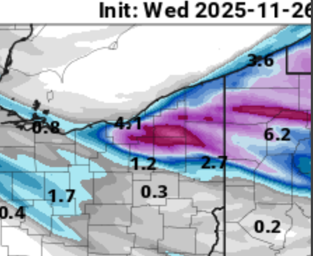
Nov 28-30th Post Turkey Day Wintry Potential
Radtechwxman replied to Chicago Storm's topic in Lakes/Ohio Valley
You watch your mouth. Don't speak it into existence. Lol Low ratios and snow falling during day in marginal temps will definitely lead to a lot of compaction. Going to be heavy wet snow -
Temp is dropping and wind starting to pick up a bit. Down to 44
-
yeah, that’s exactly what we want to see.
-
SW winds though. Kind of meh for that.
-
Snow or not, winter is coming .
-
Nov 28-30th Post Turkey Day Wintry Potential
Radtechwxman replied to Chicago Storm's topic in Lakes/Ohio Valley
Love how the one hole in lower totals in literally over my county. Lol. Can't make that $hit up -

November 2025 general discussions and probable topic derailings ...
Torch Tiger replied to Typhoon Tip's topic in New England
Some said it wouldnt happen...some were wrong -
November 2025 general discussions and probable topic derailings ...
Torch Tiger replied to Typhoon Tip's topic in New England
Near 60 at work in Chelmsford. Gorgeous! -
We are back to bashing all models that don’t show our preferred solutions and praising the models that do, no matter what model it is. gotta love this place.
-

December 2025 regional war/obs/disco thread
WinterWolf replied to Torch Tiger's topic in New England
Well to be fair Brett…this is 6-7 days away…I’d rather have it look tepid at this stage, than have it show a full blown blizzard bullseye for the area right now. And it’s gonna oscillate on guidance over the next 3 plus days. But it’s ok to say the Pattern looking more promising, but we keep expectations in check as you said earlier. -

Central PA Fall Discussions and Obs
mitchnick replied to ChescoWx's topic in Upstate New York/Pennsylvania
I feel cheated. -

December 2025 regional war/obs/disco thread
HoarfrostHubb replied to Torch Tiger's topic in New England
I like the cold look. Whether that produces anything precip-wise tbd -

December 2025 regional war/obs/disco thread
Ginx snewx replied to Torch Tiger's topic in New England
Just got a feeling from past events that modeling is underplaying Fridays windex squall potential. That's some low 500 temps. Add some lift and some streamers and some quick inch or 2 s . Something to watch..png.35513b43d61420ea7639d2c4c2b64068.png)