All Activity
- Past hour
-

Spring 2025 Medium/Long Range Discussion
Spartman replied to Chicago Storm's topic in Lakes/Ohio Valley
Ben Noll considering the lows in next week's Omega Block as bowling balls https://x.com/BenNollWeather/status/1917927485087642085 -
Maybe a couple of bangs/booms in the next 24 hours before SNE “spring” returns?
-
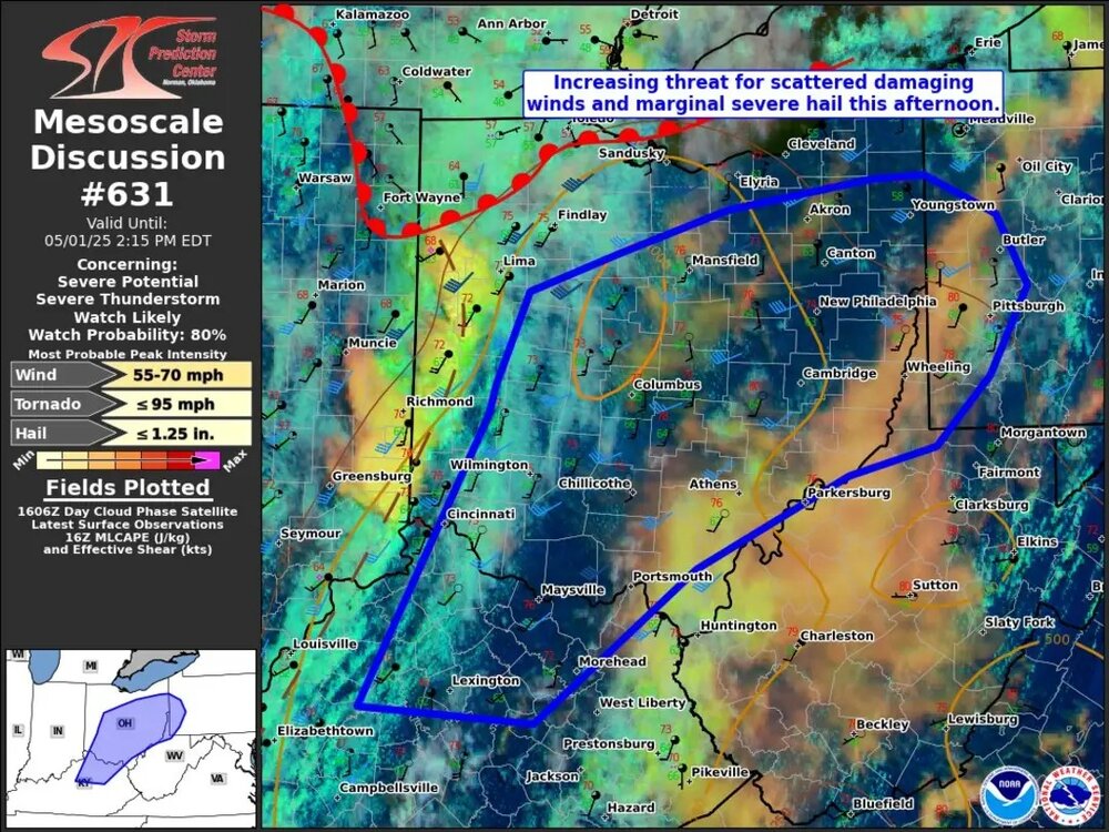
Today's theme seems to be to initially keep alot of the rain to the N and W
-
I have to look elsewhere for a map with county lines, but that 4-5 inch swath looks like it runs right up the I-81 corridor and into the Poconos.
-
I do have a feeling once this pattern breaks were going to go from cool and Damp to being Hot and muggy..
-
Just driving around yesterday I saw a lot of trees that are about to fall but still hanging on. Hopefully the severe doesn't pan out.
-
-
Hoisting a STEIN for you!
-
The vegetation would love a month's worth of rain in a week, ha.
-

Mountain West Discussion
mayjawintastawm replied to mayjawintastawm's topic in Central/Western States
First week of May always seems to be the only gloomy, wet week of the year here in the Denver Metro (I'll take it!)- 0.40" rain last night and several days more predicted next week. -
I don’t think so - the atmosphere this far east isn’t really scooting this afternoon. 75 at 1. The next week looks, as stated, wet.
-
GFS sucking in a STS day 12? edit. moves east but close
-
About 28 this morning, same as IZG. Makes 26 of 28 for May having 20s. Last year's low was 30 and 1998 had 32. However, we moved here from Gardiner on 5/15/98 so records here began on 5/17. Gardiner had lows of 33, 32 on 13th, 14th and mornings are several degrees here. April numbers: Avg max: 52.0 -0.1 Warmest, 77 on the 29th Avg min: 30.9 +2.1 Coldest, 14 on the 10th Mean: 41.4 +1.0 Precip: 3.39" -0.68" Wettest day, 0.89" on the 26th. Last year we had 1"+ days on 10 of 12 months, 17 overall. Thru today, 2025 has had none. Snowfall: 2.4" -2.6" Greatest, 1.6" on the 8th April 2025 switched gears on the 14th. Thru the 13th temps averaged 41/27, 3.0 BN, and had flakes on 6 days. Highest in that span was 52. The final 17 days averaged 60/34, 3.8 AN, and was flake free. Lowest max was a modest 47 and 11 days were 60+.
-
I actually prefer those 86/78 dats we get quite often now
-
CMC floods through day 10 with that coastal cutoff in PA... we would still get some after this
.thumb.png.345443f1bc7efaa98e7460d0d0a16b86.png)
-
Don’t need 4” of rain
-
12z CMC has a coastal day 8..
-
This weekend is going to feel cool after some muggy evenings this week. Then next week looks like overnight lows stay nice with near perfect afternoons in the 70s. Above normal heights North with normal South will be nice as long as we can keep it going. Brings ample rain. Keeps temps in check. Sure be nice into summer.
-
12z CMC still likes PA for the heaviest but came east from 0Z and gives almost all of SNE 2 to 3.5
-
12z GFS
.thumb.png.069c322863f2b136a11f8c8a46077ddf.png)
-
Hoping we miss the severe weather today after the wild storm on Tuesday. Not looking super good though, with the temperature up to 80F already.
-
I used to be like that. Now I embrace the heat and dews. I wouldn't mind some of those high 90s/low 60s dew days though. Been tough to get one of those last several years.
- Today
-
That's a stein look here, relatively speaking. Just caught myself doing it..stein has really become an overused term. Still wet here, but much more to the west.
-
I'll say though, I think I had a bit of a different mindset on this then I did yesterday. Based on the synoptic look, I am not sure if the placement or even strength of the ULL will matter all too much in terms of sensible weather. We are going to see a flow off the water with sufficient lift so I think it will be wet, just a matter of whether its widespread inches of rain or something less. This is where strength/placement will have the biggest say.
-
I'd like some free water for the plants but whoever put up the drywall to our west did a heckuva job.


.png.cf33c946c26c6a65f8a8d42fdbc958b1.png)


.png.674fbf50ee97150f2c88d1f3df19a47d.png)


