All Activity
- Past hour
-

November 2025 general discussions and probable topic derailings ...
dendrite replied to Typhoon Tip's topic in New England
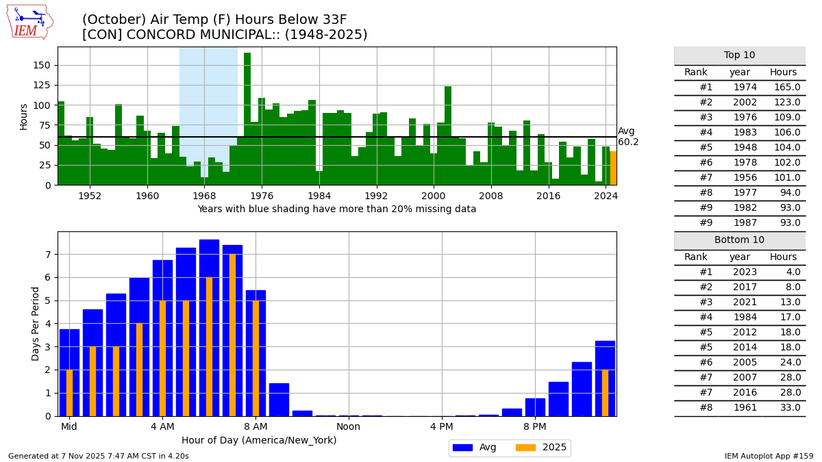
You got me curious so I had to look it up. 2023 was pathetic, but this year was a little under last year for hours of 32° or colder at CON. But man...look how much we’ve fallen since the early 2000s.
-
Certain neighborhoods in Norwell are all pines. Others all maples that drop in September.
-

New England 2025 Warm Season Banter
Damage In Tolland replied to bristolri_wx's topic in New England
Good Lord is that triggering . Still mainly green leaves . I’d list my house as quickly as possible . -
40 / 25 off a season low of 28. A bit cloudy today with some clearing later. Warmer next two days before front pushes is as trough digs into the area. Much below Mon - Wed next week and perhaps we'll see how close it gets to the 2017/2019 Nov airmass. Beyond there moderating back to / near normal.
-
Was 35° at 1AM. Figured there would be a freeze. Low ended up 33.9° lol.
-
heavy frost here-growing season definitely done
-
 I’m not looking at the data but compared to many recent past years it seemed to cool off more quickly here this year and we’ve had a number of frost and freeze starting in October instead of November like it has been in some years. Seems to be setting up for some good early winter actually Over the next 4 to 6 weeks. I’m looking forward to it.
 -
I believe Howard was already done? Let me check EDIT - NW Howard County had their growing season declared over by LWX on Oct 25th 909 NOUS41 KLWX 251344 PNSLWX MDZ004-005-503-505-VAZ056-505-506-526-260145- Public Information Statement National Weather Service Baltimore MD/Washington DC 944 AM EDT Sat Oct 25 2025 ...GROWING SEASON HAS ENDED FOR THE PORTIONS OF WEST-CENTRAL MARYLAND, NORTHERN VIRGINIA, AND THE NORTHERN NECK OF VIRGINIA... Based on freezing temperatures last night into this morning, the growing season has been declared over for the following counties: In Maryland: Carroll, northwest Howard, northwest Montgomery, and Frederick In Virginia: Loudoun, northwest Prince William, Spotsylvania As a result, no Frost/Freeze headlines will be issued for these areas until Spring 2026.
-
November 2025 general discussions and probable topic derailings ...
dendrite replied to Typhoon Tip's topic in New England
What
-
November 2025 general discussions and probable topic derailings ...
dendrite replied to Typhoon Tip's topic in New England
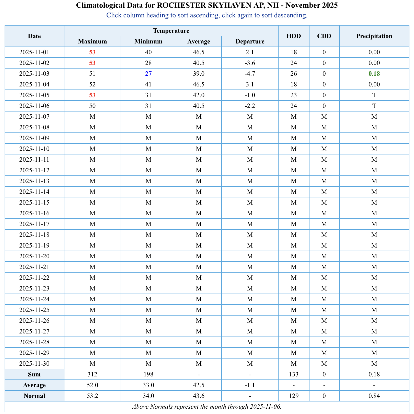
CON is -2.2 mtd. MHT -2.7. -
Farmingdale too, low there was 31.
-
Bottomed out at 31F here.
-
Hmmm. Doesn’t say Howard, but has everywhere around us?
-
27.6 degrees for the low here. Nice inversion ongoing, high up (+3500 elevation) is in the low 40's with valleys in mid to upper 20's. Currently 29.8/25.0 at 8 am with just a bit of high cirrus in the sky.
-

November 2025 general discussions and probable topic derailings ...
CoastalWx replied to Typhoon Tip's topic in New England
Tomorrow AN for sure. Should be a nice day. -
November 2025 general discussions and probable topic derailings ...
CoastalWx replied to Typhoon Tip's topic in New England
2nd,3rd, and yesterday. Today will avg BN I think. Logan was 33 this morning. -
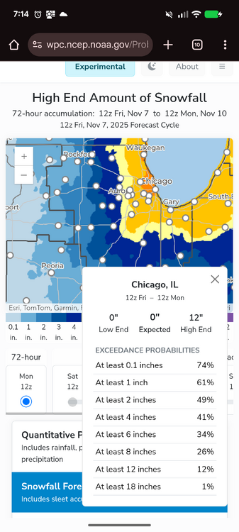
Current forecast for Chicago is LOL worthy.
-
(002).thumb.png.6e3d9d46bca5fe41aab7a74871dd8af8.png)
Central PA Fall Discussions and Obs
ChescoWx replied to ChescoWx's topic in Upstate New York/Pennsylvania
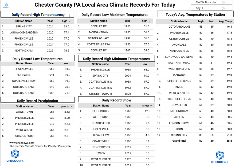
The NWS has terminated the growing season across the entire area as most spots have now seen freezing or frost conditions this season. The only exception remains the highest spots in our area including Atglen, West Grove and here in East Nantmeal where we only dropped down to 33.9 this morning. Our typical coldest spot just a few miles north of here at Warwick Township dropped to 24.2 degrees this morning - almost a 10-degree swing based on elevation. That was the 10th sub-freezing low this season at Warwick. Here in East Nantmeal we will have to wait for our first freeze till our cold shot that arrives on Monday night. The latest first freeze I have recorded here was last year on November 13th. Today we will see high temperatures well up into the 50's. Some showers are likely tonight before our warmest day for the next week tomorrow with highs into the low 60's. We start to cool down on Sunday with more rain possible into the evening before we turn much colder to start the new work week we could even see a snow flurry by Monday night.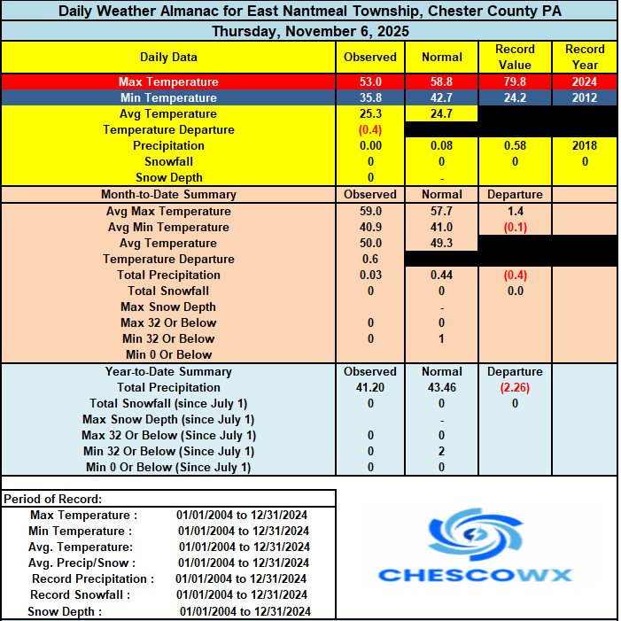
-

November 2025 general discussions and probable topic derailings ...
HimoorWx replied to Typhoon Tip's topic in New England
Finally below freezing for the first time. 29.8 for the low. -
E PA/NJ/DE Autumn 2025 Obs/Discussion
ChescoWx replied to PhiEaglesfan712's topic in Philadelphia Region
The NWS has terminated the growing season across the entire area as most spots have now seen freezing or frost conditions this season. The only exception remains the highest spots in our area including Atglen, West Grove and here in East Nantmeal where we only dropped down to 33.9 this morning. Our typical coldest spot just a few miles north of here at Warwick Township dropped to 24.2 degrees this morning - almost a 10-degree swing based on elevation. That was the 10th sub-freezing low this season at Warwick. Here in East Nantmeal we will have to wait for our first freeze till our cold shot that arrives on Monday night. The latest first freeze I have recorded here was last year on November 13th. Today we will see high temperatures well up into the 50's. Some showers are likely tonight before our warmest day for the next week tomorrow with highs into the low 60's. We start to cool down on Sunday with more rain possible into the evening before we turn much colder to start the new work week we could even see a snow flurry by Monday night.
-
Here in Raleigh we kind of have a double peak with different trees. We just had the peak of the first wave I think:
-
That’s a great point PF. I hadn’t thought too much about it because we certainly get snowpack and skiing like this in November, but probably not too often in this part of November. Especially at this time of the season, that average snow depth at the stake is quite the “average” vs “typical”. Periods like this are the counterpoint to all those early Novembers when the pattern is just benign, pleasant, stick season weather, which happens quite often. Those videos coming out of Jay Peak definitely show how good some of the riding has been – one of my students was showing me video yesterday as he wondered why in the world he wasn’t out there: https://www.instagram.com/reel/DQuj2viEr4X/
-
36 for the low, first sub 40 of the year
-
Triple digits in Deep Creek would remind me of winters of the past there (and last year). Fingers crossed a good year for the ski resorts.