All Activity
- Past hour
-

January 2026 regional war/obs/disco thread
WxWatcher007 replied to Baroclinic Zone's topic in New England
There’s probably going to be a period of moderation, but I doubt we escape this being one of the colder winters in quite some time. Think it’ll come in from the NW, which will moderate it some for SNE. A Montreal Express seems unlikely to me right now, but hey, at least next week is really starting to show itself to be a legitimate high potential period. Signals been blaring from a mile away. -

First Legit Storm Potential of the Season Upon Us
Cold Miser replied to 40/70 Benchmark's topic in New England
I love that I have been going from freeze to mini thaw / mud season every other day. Yesterday my car sunk in 8” of mud. Then I have to rake out the ruts so I can wake up to frozen dirt. Same scene all season -

Appreciating Each Other/Poster Compliments
dailylurker replied to SnowenOutThere's topic in Mid Atlantic
When I was in 9th grade I would stare at the sky with my mouth open waiting for something interesting to happen. This kid already is head of the NWS lol -
6 hours before this frame .
-
Nice to see that the GFS Ensemble can see the northern Shenandoah valley precip hole clearly from 10 days out.
-
Surface Temps are problematic


-

First Legit Storm Potential of the Season Upon Us
ORH_wxman replied to 40/70 Benchmark's topic in New England
Let’s keep that vortmax more consolidated and get double digits. Why not. -

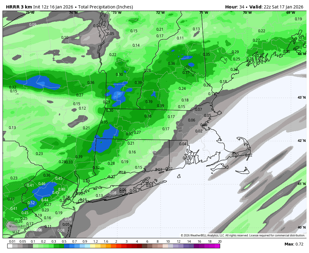
Another Coating of Snow Saturday - "It's all we Got"
The 4 Seasons replied to Sey-Mour Snow's topic in New England
Best dynamics are from Litchfield to Putnam to Morris and then the band shifts east and rips for an hour or two. its been all over the place so i wouldn't trust much of this but it really beefed up qpf across CT into LHV NJ from 6Z.
.thumb.png.bc949689e718beb44c3800c2b5c27559.png)
-

Another Coating of Snow Saturday - "It's all we Got"
HoarfrostHubb replied to Sey-Mour Snow's topic in New England
Yeah... HRRR hasn't been very good lately... not that NAMmie is great, but I tend to go with that a bit more -

Winter 2025-26 Short Range Discussion
A-L-E-K replied to SchaumburgStormer's topic in Lakes/Ohio Valley
turd duster -

Another Coating of Snow Saturday - "It's all we Got"
CoastalWx replied to Sey-Mour Snow's topic in New England
Hrrr beyond 24 hrs has been wild lately -

Winter 2025-26 Short Range Discussion
DocATL replied to SchaumburgStormer's topic in Lakes/Ohio Valley
Not a bad little morning thump but come on can we at least get a half day? . -
First Legit Storm Potential of the Season Upon Us
CoastalWx replied to 40/70 Benchmark's topic in New England
Well if it came west you aren’t going to lose dynamics at the same time. But the system itself isn’t exactly a monster. Hopefully a few more ticks west. -

Another Coating of Snow Saturday - "It's all we Got"
dendrite replied to Sey-Mour Snow's topic in New England
HRRR toned down from 6z. 3k nam is running…I’d put more faith in that. -
It’s coming from the low up north, also there’s a little vort/jet that comes up over us.
-
I still think the triangle/raleigh area is in about the best spot you can be in for the system the question then becomes if there even is a good spot on Sunday. Do think there are a few positives today vs last night but the ceiling for the event has come down even in whatever area is the sweet spot.
-
January 2026 regional war/obs/disco thread
dendrite replied to Baroclinic Zone's topic in New England
Well every run and model is flopping around with timing and intensity. The only thing consistent is there’s some good cold shots in the extended. I’d probably lean toward a cold shot that’s on par with the typical coldest of a winter. Up here that would probably be a day that’s like +10/-15. But that’s just spit balling. -

Central PA Winter 25/26 Discussion and Obs
Mount Joy Snowman replied to MAG5035's topic in Upstate New York/Pennsylvania
Low of 18. I like my chances for an inch of snow tomorrow morning. Happy Friday, all. -

January 2026 regional war/obs/disco thread
jbenedet replied to Baroclinic Zone's topic in New England
That interstate 80 region from PA to NY looks like a sweet spot, 20th to month end. Good time for you to be watching closely. -
I can’t remember what year, less than 10 years ago, but on the NW side of a line from Morristown to London got hammered from a event that was forecasted to be snow, rain, snow but CAD kept everything snow NW of that line. I ended up with 9” and the temps never got above 28°. At the same time, Sevierville was all rain in the mid 40’s. Edit this to change NE to NW of the line. .
-

Another Coating of Snow Saturday - "It's all we Got"
Kitz Craver replied to Sey-Mour Snow's topic in New England
How’s the rest of CT look? -

Storm potential January 17th-18th
donsutherland1 replied to WeatherGeek2025's topic in New York City Metro
I suspect that it will take a change on the ECMWF to shake up the current thinking. The 6z GFS might be a plausible "best case" (if one likes snow). None of last night's EPS members had anything like it, though. A single member had 3" in NYC. The 0z RGEM had something similar though it backed off somewhat at 6z. There's just enough support on the guidance to suggest a snowier solution remains possible. Maybe the AI models will come out on top. Hopefully, over time, the AI models will improve their skill and become an important forecasting tool. -
Another Coating of Snow Saturday - "It's all we Got"
The 4 Seasons replied to Sey-Mour Snow's topic in New England
That would be solid advisory level snowfall for Nrn Litchfield HRRR gone wild -

First Legit Storm Potential of the Season Upon Us
TauntonBlizzard2013 replied to 40/70 Benchmark's topic in New England
Agreed. Not sure if it’s rain, but it might be slop for a bit. The overnight runs definitely came west, but in the process, we’ve steadily lost dynamics. So while it’s closer, there is definitely still a legitimate ceiling. Assuming this doesn’t escape east over the next two days, and we do get a system, I’d be surprised if anyone got 6” of snow, just kind of has that look of a middle of the road advisory event -
HRRR has 1-3 inches for NYC tomorrow


.png.c9e0dca559a04d83ff9d331552382237.png)


