All Activity
- Past hour
-
So... being in a 'cool synergistic cage' for a week or more, it starts to get hard to visualize getting out of said cage. It kind of conditions the mind into thinking it won't get hot next week some how, some way. Not the most scientific approach of course, no, but there's something to that. It's a similar phenomenon to being in the 5th inning in the 2002 ALCS, with Pedro Martinez on the mound, with the Red Sox leading the Yankees 5-2 at the time ... and just knowing for some creepy reason that the Red Sox season was over. It was more than Grady Little's ambling out to the mound to tuck his tail between his legs when Pedro's ego told him go back. Annnnnd summarily the Yankees scored the two guys that were on base and the rest was history... It's not analogous as a comparison, per se, but just the 6th sense of it. Yet, I kind of would like one last heat departure before putting the ballast of summer in the books (watch us get a heat wave on Sept 10-13th or something...), and committing to missed hurricane season and an early frost/snow in October that heralds in another CC-denied winter shit show. weeee
-
It’s gotta change in our favor one of these years
-
 Nice, 55 here as well.
 -
I think it's interesting because that occurred with either nominal actual negative, or positive anomalies in the 500 mb heights. I'm thinking there was some environmental feed backs that synergistically aided cooler profiles to a realization. There may have been an initial push of cooler total/deep layer troposphere ending the heat wave at the tale end of July. Whatever the source ... it left, but also left a sloped soundings very left of potential aloft. Then, given our geography tending to abuse cold displacement south. If we stack synoptic denser air around the corner of White mountains... it tends not to stop until the Va Capes... I remember a lot of this cooling did come from a slow press S, and then it tipjped SW. A N-door front for us became a BD for the M/A... Then, we slabbed smoke over top during 4 of those days. I'm very suspect that it dimmed the ability to force solar modulation per the course. Yet another factor ... the high pressure moves more E than S, which keeps winds light and none mixing, as well as oceanic contribution (although the flow's been admittedly very light in this latter regard) It's been a hodge-podge of physical feed-backs teaming up. Just in principle, it's a bit incongruous to get this kind of persisting negative low level temperature result, when under heights persistently above 582 and even approaching 590 at times. Even the thickness' were above 560 per the course. We've observed temperatures close to 90 at 564 dm thickness. yet days pinned in the 70s. So these metrics demo that this was a bit of an unusual occurrence. Not signifying or implicating anything other than the objective observation of these field metrics vs results.
-

2025-2026 ENSO
Stormchaserchuck1 replied to 40/70 Benchmark's topic in Weather Forecasting and Discussion
January on the Euro seasonal looks like -EPO/-AO -
Yeah, that PDO is bad as of now. Last year at this juncture it was low but not this low and it managed to rise rapidly in November. That helped irt last Winter without a doubt.
-
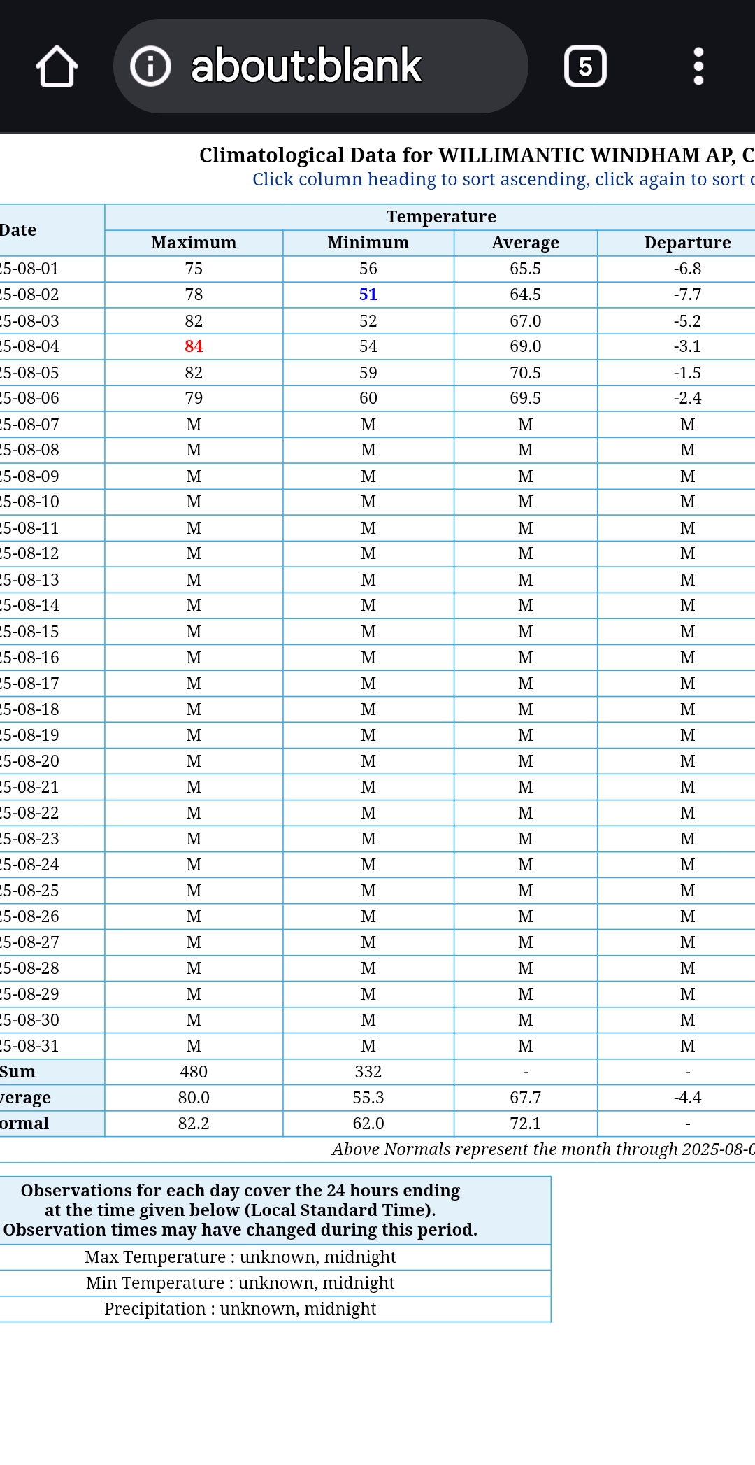
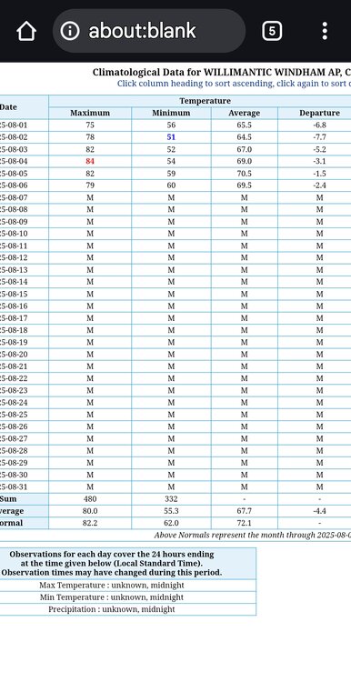
Shwrs/stms moving in slowly this morning. Aug has been dry here so far, so hope to see precip today. Yesterday was a steamer with temps around 90 with mid 70 dews.
-
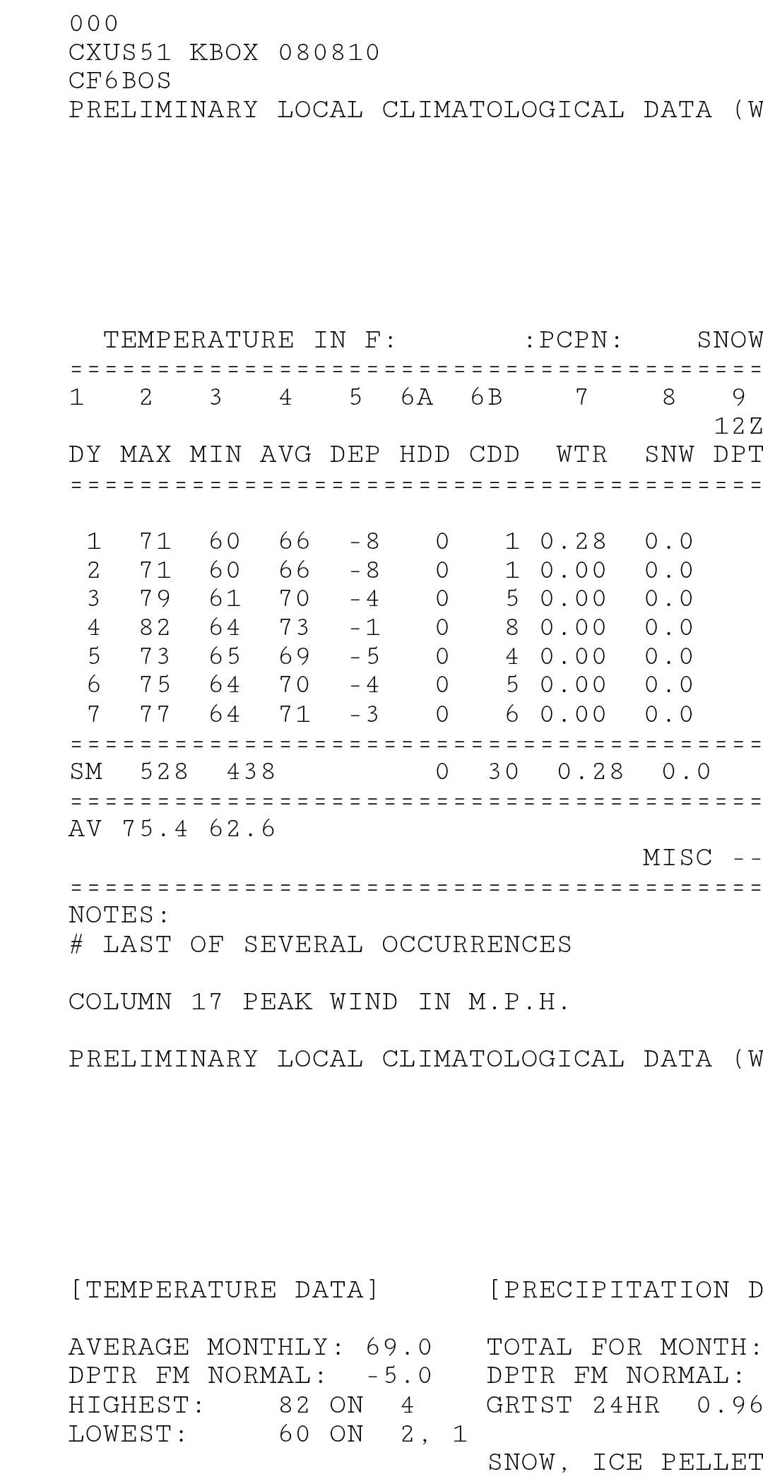
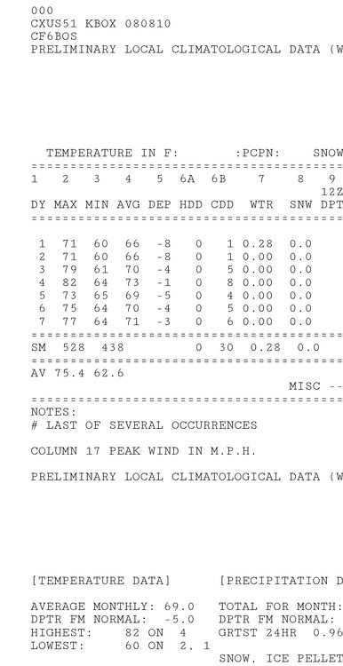
Another chilly start of the day across much of the area with temperatures well down into the 50's. The chilliest station I could find was the Warwick DEOS station at 52.1 degrees. Through the first week of August we are running almost 7 degrees below normal temperatures for the month. We should slowly start to turn this temperature deficit around during the next week. We start a solid warming trend on Sunday with temperatures finally getting back to above normal levels. By mid-week some of the lower elevation spots may reach the 90's with increasing humidity to add to the discomfort. The week looks dry with maybe our first shot of rain arriving by later Thursday.
-
Ya that run was .. i think somewhere on the east coast gets hit the next couple of weeks.. i hope its us
-

E PA/NJ/DE Summer 2025 Obs/Discussion
ChescoWx replied to Hurricane Agnes's topic in Philadelphia Region
Another chilly start of the day across much of the area with temperatures well down into the 50's. The chilliest station I could find was the Warwick DEOS station at 52.1 degrees. Through the first week of August we are running almost 7 degrees below normal temperatures for the month. We should slowly start to turn this temperature deficit around during the next week. We start a solid warming trend on Sunday with temperatures finally getting back to above normal levels. By mid-week some of the lower elevation spots may reach the 90's with increasing humidity to add to the discomfort. The week looks dry with maybe our first shot of rain arriving by later Thursday. -
Given the likely higher than average (though still extremely unlikely) chance of a tropical impact this season, recent interesting model runs, and the tropical clutter in the August disco, I figure it’s time to bring back the tropics megathread!
-
Serious post for a change. As we head into a heat wave. This is an impressive start for August even on the coast like Bos but inland as well IJD.
-
Just off the top of my head, it seems that the W areas have seen stronger spikes in temps earlier in the season than over your way in recent years. Just the way the pattern ball bounces.
- Today
-

Mid to long range discussion- 2025
WinstonSalemArlington replied to wncsnow's topic in Southeastern States
BAM Weather -
Yeah
-
It has to be fall. The Honey Crisp apples have been available for a week. The crop is early this year.
-
Hype day 3 no smoke COC
-
I feel like it will be warmer tonight? Maybe similar to last night. There were 40s here in ern areas last night.
-
Might be some 40s tonight in CT
-
On that note, we make it through the weekend without a drop of rain recorded at PIT, it will be the first time in the entire threaded record that there hasn’t been at least a trace of rain for the first 10 days of August.
-
Currently 72. Have been noticing the tree line behind my house is thinning out. Lot of leaves starting to fall out here also. All those gains we got back in May have been zeroed out.
-
Good to read from ya, bro! I will be bookmarking that station, thanks! Hope all is well.
-
Chicago does average more 90F+ days than Detroit (avg 17 to 13). But the last several years have been huge differences. The last 3 years, ORD has had 67 days of 90F+ while DTW only 26! Here are the last 20 years. YR - DTW – ORD 2025- 10 – 23 2024- 14 – 23 2023- 2 – 21 2022- 15 – 16 2021- 13 – 22 2020- 17 – 31 2019- 10 – 14 2018- 26 – 26 2017- 7 – 16 2016- 23 – 16 2015- 10 – 10 2014- 4 – 3 2013- 7 – 13 2012- 30 – 46 2011- 23 – 22 2010- 17 – 21 2009- 4 – 4 2008- 7 – 6 2007- 14 – 19 2006- 11 – 15
-
Meanwhile Columbia, South Carolina has been below 80 since August 1st... Sent from my SM-S166V using Tapatalk