All Activity
- Past hour
-

Occasional Thoughts on Climate Change
donsutherland1 replied to donsutherland1's topic in Climate Change
Greenland saw a significant rain event this year. From the NSIDC: Substantial rainfall reached the South Dome (SDM) weather station at an elevation of 2,895 meters (9,498 feet) above sea level, with more than 30 millimeters (1 inch) recorded at the SDM weather station on August 14 and 15, per Denmark’s Programme for Monitoring of the Greenland Ice Sheet (PROMICE) (Figure 3b). This is an exceptional amount of rain at this altitude. A similar amount of rain, 29 millimeters (1.14 inches) over August 14 and 15, was also recorded above Nuuk at the NUK_U weather station, at an elevation of 1,122 meters (3,680 feet). In later warm-front pulses during the melt event, the weather station at Swiss Camp recorded 4 millimeters (0.16 inches) of rain on August 18. Earlier, the Swiss Camp station recorded 10 millimeters (0.4 inches) of rain during the mid-July melt event. The first important rain event observed at Summit Station occurred on August 14, 2021. Both rain and surface melting occurred at the same location. -

2025 Atlantic Hurricane Season
NorthHillsWx replied to BarryStantonGBP's topic in Tropical Headquarters
Probably not tropical but the low off the Carolina coast could become quite strong when it moves ashore. Some guidance shows winds approaching 50 kts -
What TS? Mario die lol
-
83 was the high here.
-
88 was my high. Full on summer weather. And the ground is cement.
-
RMNP has snow at the Alpine Visitor Center
- Today
-
There's no storms except for Erin.
-
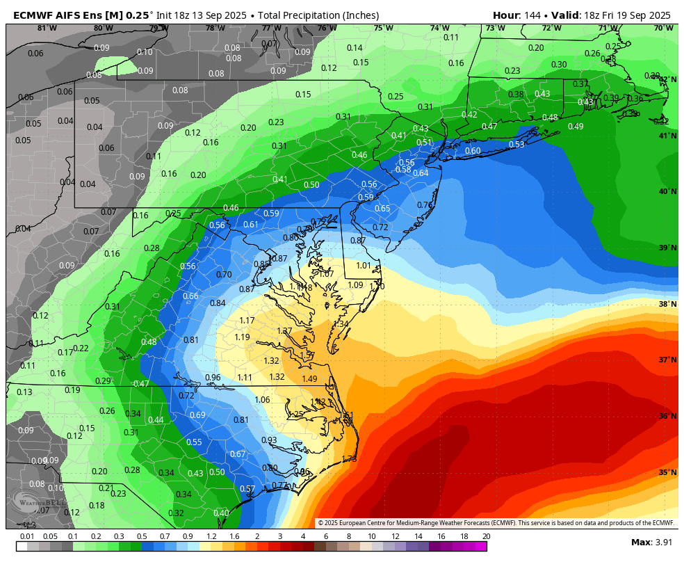
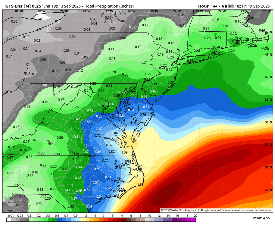
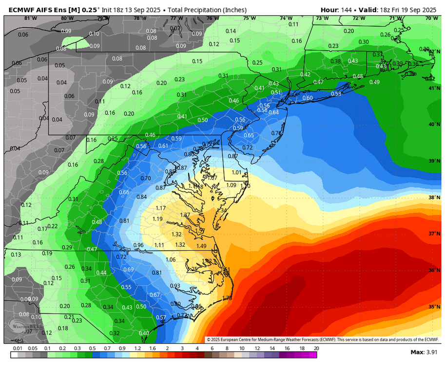
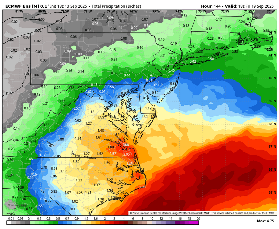
WB 18Z ensemble rain totals thru day 6. GFS, EURO AI, and Euro.
-
Made it to 97 at DVN today, 96 at MLI.
- Yesterday
-
another? they haven't even been bad here.. I was from the valley.. a shit winter here is a great winter there
-
Can you pin September? Thanks.
-

September 2025 OBS-Discussion centered NYC subforum
Santa Claus replied to wdrag's topic in New York City Metro
couple showers popping on the front but not much to work with -
Nice looking houses
-
2025-2026 ENSO
donsutherland1 replied to 40/70 Benchmark's topic in Weather Forecasting and Discussion
It's more common than one might expect. Here's the data for winters 1979-80 through 2024-25: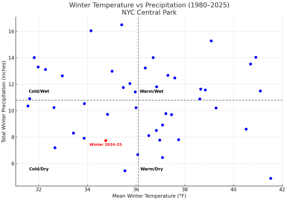
-
Nice. This has been my high point so far.

-
Dude just admit you're worried it's gonna be another disappointing winter. We all are.
-
Costly game tho and not even about the loss. Two key players done for the season
-

September 2025 OBS-Discussion centered NYC subforum
lee59 replied to wdrag's topic in New York City Metro
75.5 my high -
I wonder if reads this board lol
-
Packers super bowl betting odds really jumped over the last 2 weeks. They were 1/20, then traded for Parsons and went to 1/14, to now 1/6.5. 1. Bills 2. Packers
-
Followup: Today’s EW for weeks 2-4 has significantly more ACE than that of the last 6 runs and is the most active for that 3 week period yet with AN/active each week. Whereas the run from 2 days ago had 40 ACE for 9/15-10/12, this new run has 8+16+13.5+10.5=48. It also shows increased risk to the SE US/Gulf 10/6-12.
-
Beer
-
2025 Atlantic Hurricane Season
NorthHillsWx replied to BarryStantonGBP's topic in Tropical Headquarters
Never count out October in the gulf but east coast is fighting climo into October for significant landfalls. Obviously there are exceptions -
The sky
-
September 2025 OBS-Discussion centered NYC subforum
donsutherland1 replied to wdrag's topic in New York City Metro
Through today, September 2025 has seen just two days with highs of 80° or above in Central Park. The last time there were as few such days during the September 1-13 period was 2009. Tomorrow will be somewhat warmer with widespread highs in the lower 80s. Temperatures will top out in the upper 70s to perhaps lower 80s on Monday and Tuesday. Similar conditions could prevail on Wednesday and Thursday. A cutoff system near the Delmarva could bring some showers or rain to parts of the Jersey Shore and eastern Long Island on Wednesday into Thursday. September 1-15 remains on track to achieve a solid cool anomaly. Since 2000, there have been nine years that saw a cooler than normal first half of September. Two-thirds of those years went on to record a warmer than normal second half of September. Only two of those years (2017 and 2019) wound up with a monthly mean temperature of 70.0° or above. Overall, for two-thirds of those years, the cool start was sufficiently cool to produce a cooler than normal monthly anomaly. The last year that saw both a cooler than normal first half and second half of September was 2009. Prior to that, it was 2001. The last year to record a cooler than normal first half of September followed by a warmer than normal September was 2024. The ENSO Region 1+2 anomaly was -0.3°C and the Region 3.4 anomaly was -0.4°C for the week centered around August 27. For the past six weeks, the ENSO Region 1+2 anomaly has averaged +0.33°C and the ENSO Region 3.4 anomaly has averaged -0.32°C. La Niña conditions will likely develop during mid- or late-autumn. The SOI was -9.21 today. The preliminary Arctic Oscillation (AO) was +0.225 today. Based on sensitivity analysis applied to the latest guidance, there is an implied near 53% probability that New York City will have a cooler than normal September (1991-2020 normal). September will likely finish with a mean temperature near 69.0° (0.2° below normal). Supplemental Information: The projected mean would be 1.0° above the 1981-2010 normal monthly value.